Mount Constance
Mount Constance is a peak in the Olympic Mountains of Washington and the third highest in the range. It is the most visually prominent peak on Seattle's western skyline. Despite being almost as tall as the ice-clad Mount Olympus to the west, Mount Constance has little in the way of glaciers and permanent snow because the eastern, and particularly this northeastern, portion of the Olympics receives far less precipitation.[3] However the narrow and steep Crystal Glacier still exists on the mountain's north face, shaded by the bulk of the main peak and with a small lake at its terminus. In addition, the treeline is higher here than mountains to the west, also hinting at the drier alpine conditions.
| Mount Constance | |
|---|---|
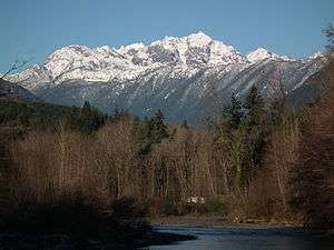 View from U.S. Highway 101 in Dosewallips State Park | |
| Highest point | |
| Elevation | 7,756 ft (2,364 m) [1] |
| Prominence | 1,956 ft (596 m) [1] |
| Coordinates | 47°46′22″N 123°07′38″W [2] |
| Geography | |
 Mount Constance Jefferson County, Washington, U.S. | |
| Parent range | Olympic Mountains |
| Topo map | USGS Mount Deception |
| Geology | |
| Age of rock | Eocene |
| Mountain type | Basalt rock |
| Climbing | |
| First ascent | 1922 by Robert Schellin and A.E. Smith |
| Easiest route | Rock & Ice climb |
By virtue of its position at the eastern edge of the Olympics, Mount Constance also enjoys spectacular vertical relief. For example, it rises over 6,900 feet (2,100 m) above the Dosewallips River to the south in only 3 horizontal miles (5 km). It is also only 12 miles (20 km) from the tidewater of Hood Canal. The summit of Mount Constance lies on the boundary between Olympic National Park and Buckhorn Wilderness. The Constance massif includes Mount Constance, Inner Constance, the twin peaks of Warrior to the north, as well as numerous subsidiary summits on rocky southern ridges enclosing the cirque basin that contains Lake Constance.
History
In 1853, surveyor George Davidson named three mountains in the Olympics. He named Mount Ellinor for Ellinor Fauntleroy, who later became his wife, Mount Constance for Ellinor's older sister and The Brothers for her two brothers.[4]
Climbing

Routes on the mountain are from Class 3 to mid-Class 5, with ratings from Grade 2 to Grade 4.[5] Mount Constance was first climbed in 1922 by R. Schellin and A.E. Smith from the southeast.
Access
Boulder Ridge (including the Gargoyles, Charlia Lakes, Cloudy Peak, Alphabet Ridge, and Warrior) and Home Lake / Constance Pass are readily accessed via the Buckhorn Wilderness Area (U.S. Forest Service) side of the Upper Dungeness River Trail and Marmot Pass. An alternative approach to the Mount Constance massif—including Inner Constance and the twin peaks of Warrior—is via the Dosewallips River Trailhead off of US 101 and Hood Canal. A third alternative is to access the Constance massif via Quilcene logging roads (FS 2700 aka "Penny Creek Road" off U.S. 101) leading to a brief 6 to 7 miles (10 to 11 km) ascent to Tunnel Creek Ridge and the high alpine shores of Harrison Lake. In fact, the most stunning views of the east side of Mount Constance and Warrior are readily available from these roads (the lower portions of which are paved) which actually connect to FS 2800 and the Dungeness / Sequim area via the 5000-foot Bon Jon Pass.
References
- "Mount Constance, Washington". Peakbagger.com.
- "Mt Constance". NGS data sheet. U.S. National Geodetic Survey.
- Google Earth images.
- "The story of three Olympic peaks". Washington Historical Quarterly. 4 (3): 182–86. Retrieved 2011-01-05.
- Olympic Mountain Rescue (1988). Climber's Guide to the Olympic Mountains (3rd ed.). Seattle WA: The Mountaineers. p. 104.