Modoc Point
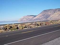
Modoc Point is a cliff on the east shore of Upper Klamath Lake, in Klamath County, Oregon, United States, approximately 15 miles north of Klamath Falls on U.S. Route 97.[1] It is part of the larger cliff known as Modoc Rim or Modoc Ridge.[2]
The point is named for the Modoc tribe of Native Americans because it was assigned to them when they moved on to the Klamath Reservation, following a treaty in 1864. This area was then part of the reservation. Captain Jack and his band lived in this area from December 31, 1869, to April 26, 1870.[3] Due to continued harassment by the Klamath, the Modoc left the reservation to return to their traditional territory to the south on the Lost River in present-day California. This was before the Modoc War (1872-1873).[3][4]
Klamath folklore frequently features this location; they called it Kiuti or Muyant. It was also called Nilakla, meaning "dawn" or "sunrise".[3] William G. Steel stated that the point was known as Nilakla, the Klamath word for "dawn" or "sunrise".[3]
Modoc Point was the namesake for a railroad station and post office just north of the point.[3]
References
- "Modoc Point". Geographic Names Information System. United States Geological Survey. November 28, 1980. Retrieved 2010-01-13.
- "Modoc Rim". Geographic Names Information System. United States Geological Survey. March 1, 1994. Retrieved 2010-01-13.
- McArthur, Lewis A.; McArthur, Lewis L. (2003) [1928]. Oregon Geographic Names (7th ed.). Portland, Oregon: Oregon Historical Society Press. p. 653. ISBN 978-0875952772.
- Friedman, Ralph (1993) [1972]. Oregon for the Curious (3rd ed.). Portland, Oregon: Pars Publishing Company. pp. 165–166. ISBN 0-87004-222-X.