Miquelon Island
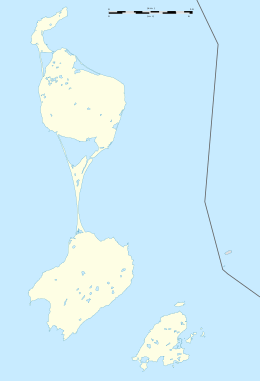
Miquelon (French: Île Miquelon) also known as Grande Miquelon, is one of the islands of the archipelago of Saint Pierre and Miquelon, an Overseas collectivity of France located in the Atlantic Ocean, 22 kilometres (14 mi) south of the coast of Newfoundland. Miquelon is situated between Le Cap Island to the north and Langlade Island (also called Petite Miquelon) to the south.[1]
| Native name: Île Miquelon | |
|---|---|
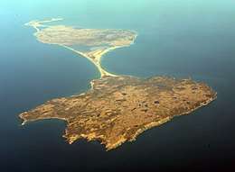 Miquelon Island in the center, south of Le Cap and north of Langlade Island | |
 Miquelon | |
| Geography | |
| Location | Atlantic Ocean |
| Coordinates | 47°03′26.1″N 56°20′19.2″W |
| Archipelago | Saint Pierre and Miquelon |
| Adjacent bodies of water | Gulf of Saint Lawrence |
| Area | 110 km2 (42 sq mi) |
| Highest point | Morne de la Grande Montagne (240m) |
| Administration | |
| Overseas collectivity | Saint Pierre and Miquelon |
| Largest Commune | Miquelon-Langlade |
| Demographics | |
| Demonym | Miquelonnais |
| Population | 626 (2012) |
| Languages | French |
| Additional information | |
| Official website | http://www.miquelon-langlade.com |
Toponymy
The name Miquelon purportedly derived from a Basque nickname for "Michael" (Mikel). In 1579, the names Micquetõ and Micquelle appeared for the first time in French Basque mariner Martin de Hoyarçabal's maritime pilot. The name evolved over time into Miclon, Micklon, and finally Miquelon (Mikelune in Basque).[2][3]
Geography
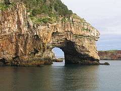
Miquelon's coastline includes numerous sand and pebbles beaches enclosing lagoons, as well as high rocky cliffs standing up to 25 metres (82 ft) on the east coast. Its geology consists of slightly metamorphosed post-Ordovician volcanic rocks, mainly rhyolites with breccias, andesites and basalts. On the south of the Miquelon Island is a large lagoon known as the Grand Barachois, which is host to a large population of seals and other wildlife. Miquelon is also a well known destination for bird watching.[1]
Miquelon is connected to Le Cap by a tombolo 3 kilometres (1.9 mi) long and in places less than 100 metres (330 ft) wide. To the south, Miquelon is connected to Langlade Island by a sandy isthmus that formed in the 18th century that is 12 kilometres (7.5 mi) in length from 100 metres (330 ft) to 6 metres (20 ft) wide.[2]
The island of Saint Pierre Island is across a treacherous and foggy 6 kilometres (3.7 mi) strait that fishermen named "The Mouth of Hell" (French: La Gueule de L'Enfer) that has been the site of more than 600 shipwrecks.[2][4]
Climate
The climate is typical of the North Atlantic and the Labrador Current, with frequent storms and winds that exceed 60 kilometres per hour (37 mph) for nearly six months of the year. The summers are cool and foggy. The average annual temperature is 5.5 °C (41.9 °F).[1]
Population
Miquelon includes the commune of Miquelon-Langlade, with a population of 626 in 2012. Miquelon Airport serves the population via turboprop or small jet aircraft. The majority of the residents live in the town also called Miquelon, located in the north of the island near La Cap. The residents are known as Miquelonnais and are citizens of France.[5]
Gallery
 Miquelon shore
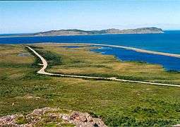 The north coast of Miquelon, next to Le Cap
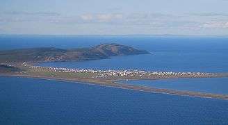 The village of Miquelon seen from the west
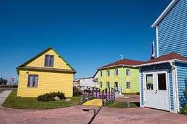 House in the village
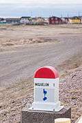 Milestone to Miquelon
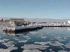 The port of Miquelon
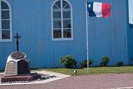 Acadien monument
See also
References
- Bird, Eric. Encyclopedia of the World's Coastal Landforms. Springer Science & Business Media. pp. 163–165. ISBN 9781402086380. Retrieved 16 November 2016.
- "1579 – Voyages Avantureux, Martin de Hoyarçabal". Grand Colombier. Retrieved 16 November 2016.
- Les Français peints par eux-mêmes: encyclopédie morale du dix-neuvième siècle (in French). L. Curmer. 1840. p. 640. Retrieved 16 November 2016.
- Edward, David A. O.; Lane, Robert (2013). Edward and Lane on European Union Law. Edward Elgar Publishing. p. 81. ISBN 9780857931054. Retrieved 16 November 2016.