Melinka
Melinka is a Chilean town in Aysén Province, Aysén Region. It is located on Ascención Island and is the administrative center of the commune of Guaitecas since 1979.
Melinka Isla Melinca | |
|---|---|
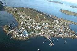 Aerial view of Melinka | |
 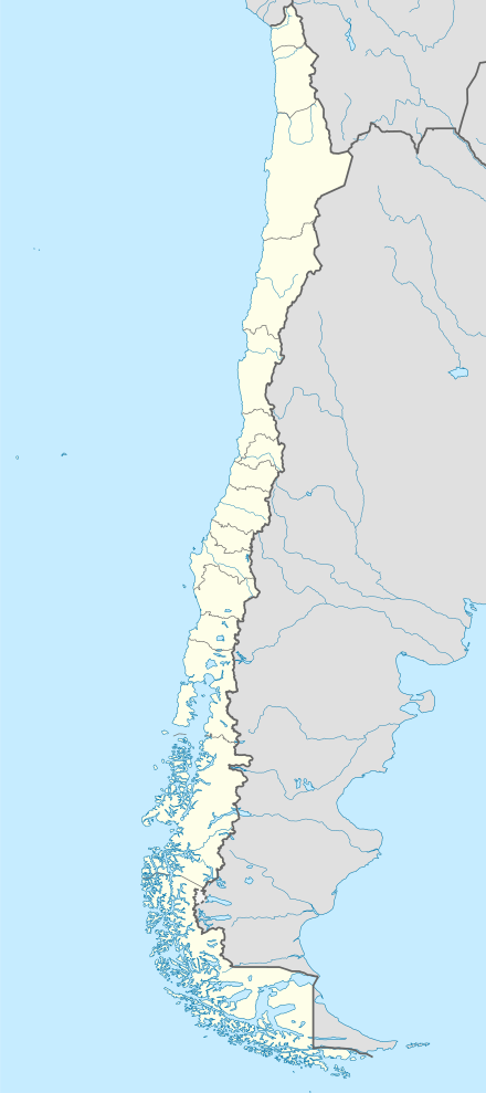 Melinka Location in Chile | |
| Coordinates: 43°53′52″S 73°44′38″W | |
| Region | Aisén |
| Province | Aisén |
| Commune | Guaitecas |
| Government | |
| • Alcalde | Luis Antonio Miranda Chiguay |
| Population | |
| • Total | 1,411 |
| Time zone | UTC−04:00 (Chilean Standard) |
| • Summer (DST) | UTC−03:00 (Chilean Daylight) |
| Area code(s) | Country + town = 56 + ? |
| Climate | Cfb |
The town is on a small peninsula off the main island, and shelters a small harbor. The island is in the Guaitecas Archipelago, at the southern end of the Gulf of Corcovado.[1][2] Melinka is served by Melinka Airport and is connected by gravel road to the hamlets of Repollal.
Melinka is culturally similar to Chiloé Archipelago[3] but its inhabitants custom to bring dogs on board in their travels is likely rooted in native Chono traditions.[4][5]
History
Melinka was founded in 1860 by the German immigrant, Felipe Arnold Westhoff.[6] Westhoff had been commissioned to supply railway sleepers to Ferrocarril Central Andino in Peru.[6] At the time the Guaitecas Archipelago was still part of Chiloé Province. In the first years of Melinka a series of indigenous tombs were discovered while building houses.[7] From Melinka Westhoff exported Pilgerodendron uviferum (Spanish: ciprés de las Guaitecas) that made excellent wood for sleepers.[6] In 1870 the port was charted by Enrique Simpson on board Chacabuco.[8]
The famous pirate Pedro Ñancúpel was captured in Melinka in 1886 and bought into justice in Ancud the same year.[9][10]
According to a local tradition the word melinka comes from Russian and means lovely. In fact, there is the Russian archaic colloquialism милёнка (transl. milyonka) which means "lovely."[11] Westhoff who came from Lithuania in the Russian Empire named Melinka after his sister.[10]
Climate
Melinka has a wet oceanic climate (Köppen climate classification: Cfb).
| Climate data for Melinka | |||||||||||||
|---|---|---|---|---|---|---|---|---|---|---|---|---|---|
| Month | Jan | Feb | Mar | Apr | May | Jun | Jul | Aug | Sep | Oct | Nov | Dec | Year |
| Average high °C (°F) | 17.4 (63.3) |
17.2 (63.0) |
15.9 (60.6) |
13.6 (56.5) |
11.3 (52.3) |
10.1 (50.2) |
10.0 (50.0) |
10.0 (50.0) |
10.9 (51.6) |
13.2 (55.8) |
13.8 (56.8) |
15.7 (60.3) |
13.3 (55.9) |
| Daily mean °C (°F) | 13.3 (55.9) |
13.2 (55.8) |
12.0 (53.6) |
10.4 (50.7) |
8.8 (47.8) |
7.7 (45.9) |
7.6 (45.7) |
7.3 (45.1) |
7.8 (46.0) |
9.5 (49.1) |
10.3 (50.5) |
12.0 (53.6) |
10.0 (50.0) |
| Average low °C (°F) | 9.6 (49.3) |
9.5 (49.1) |
8.7 (47.7) |
7.4 (45.3) |
6.0 (42.8) |
5.0 (41.0) |
5.0 (41.0) |
4.6 (40.3) |
4.8 (40.6) |
6.1 (43.0) |
7.0 (44.6) |
8.5 (47.3) |
6.9 (44.4) |
| Average precipitation mm (inches) | 152.2 (5.99) |
168.2 (6.62) |
216.8 (8.54) |
270.1 (10.63) |
349.4 (13.76) |
367.8 (14.48) |
382.5 (15.06) |
325.2 (12.80) |
256.9 (10.11) |
191.6 (7.54) |
247.0 (9.72) |
246.0 (9.69) |
3,137.7 (123.53) |
| Source: Bioclimatografia de Chile[12] | |||||||||||||
See also
References
- Google Maps - Melinka
- OpenStreetMap - Melinka
- Saavedra Gallo, Gonzalo (2011). "Tensiones modernizantes y condicionantes culturales del desarrollo en el borde costero del Sur Austral chileno" [Modernizing tensions and cultural conditioners of development in the south austral Chilean coastal seaboard]. Revista Lider (in Spanish). 19: 201–219.
- Álvarez A., Ricardo; Navarro P., Magdalena; Saavedra G., Gonzalo; Donoso C., Cristián (2015). "Referencias exploratorias sobre el lago Presidente Ríos, para sortear el Istmo de Ofqui, Península de Taitao, Región de Aysén" [Exploratory references on Presidente Ríos lake, for routes round the Ofqui Isthmus, Taitao Peninsula, Aysén Region, Chile]. Magallania (in Spanish). 43 (1). doi:10.4067/S0718-22442015000100006. Retrieved December 21, 2019.
- Alvarez, R. & Navarro, M. (2008). Informes Levantamiento de Información Etnográfica Usos Tradicionales del Borde Costero Provincia de Chiloé (región de Los Lagos) y Comuna de Las Guaitecas (región de Aysén). Valdivia: ONG Centro Ballena Azul, World Wildlife Fund (WWF).
- "¿Quién era Felipe Westhoff Rodhius?". eldivisadero.cl (in Spanish). Diario El Divisadero. July 28, 2012. Retrieved January 10, 2019.
- Westhoff, Felipe (1867). "Jeografía i meteorolojía chilena.-Memoria del subdelegado marítimo del archipiélago de los Chono o Guaitecas". Anales de la Universidad de Chile (in Spanish). XXIX (7): 445–450. Retrieved January 12, 2019.
- Simpson, E. (1874). Esploraciones hechas por la Corbeta Chacabuco al mando del capitán de fragata don Enrique M. Simpson en los Archipiélagos de Guaitecas, Chonos i Taitao. Santiago. Imprenta Nacional.
- Marín Lleucún, Alejandro (2015). "Puerto Gala y Puerto Gaviota (1985-1993): Una mirada desde el triángulo de la violencia" [Port of Gala and Port of Gaviota (1985-1993): A look from the triangle of violence]. Magallania (in Spanish). 43 (2). Retrieved January 10, 2019.
- Cárdenas Álvarez, Renato (January 17, 2005). "La historia del pirata chilote Pedro Ñancúpel" (in Spanish). El Llanquihue. Retrieved January 10, 2019.
Cuando es capturado en Melinka ya era una leyenda porque había evadido la persecución.
- Толковый словарь русского языка - Милёнок (in Russian). 1937. Retrieved 2013-02-12.
милёнка, м. (простореч.).
- Hajek, Ernst; Castri, Francesco (1975). "Bioclimatografia de Chile" (PDF) (in Spanish). Retrieved 23 April 2016.