Manzanares (river)
The Manzanares (Spanish pronunciation: [manθaˈnaɾes]) is a river in central Spain, which flows from the Sierra de Guadarrama, passes through Madrid, and eventually empties into the Jarama river, which in turn is a tributary to the Tagus.
| Manzanares | |
|---|---|
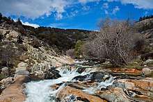
 The Manzanares through El Pardo | |
.png) | |
| Location | |
| Country | Spain |
| Region | Iberian Peninsula |
| Physical characteristics | |
| Source | Sierra de Guadarrama |
| • location | Community of Madrid, |
| • elevation | 2,010 m (6,590 ft) |
| Mouth | Jarama river |
• elevation | 533 m (1,749 ft) |
| Length | 92 km (57 mi) |
| Discharge | |
| • average | 10–15 m3/s (350–530 cu ft/s) |
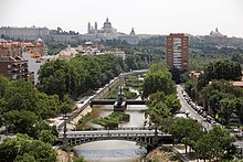
In its urban section, the Manzanares River was modified to create a section of water several meters deep, in some parts navigable by canoes. This project of channeling and damming has been partially reversed in a re-naturalization project.
Course
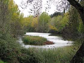
The river Manzanares has its source near the Navacerrada mountain pass in the Guadarrama mountain range. The upper river basin is protected as the Parque Regional de la Cuenca Alta del Manzanares, a nature reserve which is recognised as a biosphere reserve by UNESCO.
The Manzanares flows in a south-eastern direction from its source, and passes through the medieval town of Manzanares el Real where it is dammed to form the Santillana reservoir, one of the most important water supplies for the capital. The river then takes a southern direction and enters the Monte de El Pardo, an ecologically valuable area on the edge of Madrid.
The river was canalised where it passes through the built-up areas of the city. In the 21st century the river was restored to provide biodiversity and facilities for Madrid residents.
The Manzanares skims past the westernmost part of the city and further downstream serves as a dividing line between the old centre of the city and the Carabanchel and Usera neighbourhoods to the southwest. It is along this stretch that it passes next to Atlético Madrid's former football ground, the Vicente Calderón. The river leaves the city at its southernmost tip. It makes a strong eastern turn which takes it past the village of Perales del Río and towards the river Jarama, into which it flows near the dormitory town of Arganda del Rey, ending its 83 km (52 mi) journey.
Historical importance
.JPG)
The river Manzanares, although small and relatively unimportant geographically, has had a great historical importance due to its close relation to the city of Madrid. The city was founded by the Moors as a citadel overlooking the river in the ninth century.
The river is also featured in many paintings of the late 18th to early 19th-century painter Francisco de Goya, which show traditionally dressed Madrileños in activities like dancing or having picnics next to the river.
The Manzanares was also an important defence line for the Republican forces during the Siege of Madrid in the Spanish Civil War, and many bunkers can still be seen near the village of Perales del Río. The Bridge of the French was of crucial importance because of its strategic location. There, nationalist forces were repeatedly repelled and denied access to Madrid’s city center.[1]
See also
References
- See: Coronel Carlos Romero Giménez