MacLehose Trail
The MacLehose Trail (Chinese: 麥理浩徑) is a 100-kilometre hiking trail that crosses much of the New Territories, Hong Kong, starting from Pak Tam Chung, Sai Kung, in the east to Tuen Mun in the west. The path is marked by distance posts at 500-metre intervals. The trail is named after Sir Murray MacLehose, the longest-serving governor of Hong Kong, who established the Country Parks and was himself an enthusiastic hiker. The trail passes through a variety of natural scenery including beaches and mountains.
| MacLehose Trail | |||||||||||
|---|---|---|---|---|---|---|---|---|---|---|---|
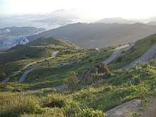 Tai Mo Shan Road weaving up the mountain along section 8 of the MacLehose Trail | |||||||||||
| Traditional Chinese | 麥理浩徑 | ||||||||||
| Simplified Chinese | 麦理浩径 | ||||||||||
| |||||||||||
The New Territories, through which the MacLehose Trail runs, covers the majority of Hong Kong's land area. The east coast, where the trail begins, is deeply indented and wild. The central mountains, which the MacLehose Trail crosses, include many of Hong Kong's highest peaks. The western part, where the trail winds to its end, features numerous valley reservoirs.[1]
_turn-off_on_Route_Twisk.JPG)
History
During the 1970s, the Hong Kong Government moved to protect Hong Kong's countryside and open it up for recreation. The Country Parks Ordinance was enacted in 1976, and the Country Parks Board was formed shortly thereafter. The MacLehose Trail was officially opened on 26 October 1979 by Governor MacLehose and E. H. Nichols, Director of Agriculture and Fisheries.[2]
Stages
The MacLehose Trail is divided into ten stages:[1]
| Stage | Route | Length (km) | Time (hr) | Difficulty | Starting Post | Ending Post |
|---|---|---|---|---|---|---|
| 1 | Pak Tam Chung → Long Ke | 10.6 | 3.0 | 000 | 020/021 | |
| 2 | Long Ke → Pak Tam Au | 13.5 | 5.0 | 020/021 | 048/049 | |
| 3 | Pak Tam Au → Kei Ling Ha | 10.2 | 4.0 | 048/049 | 068/069 | |
| 4 | Kei Ling Ha → Tai Lo Shan | 12.7 | 5.0 | 068/069 | 094 | |
| 5 | Tai Lo Shan → Tai Po Road | 10.6 | 3.0 | 094 | 115/116 | |
| 6 | Tai Po Road → Shing Mun | 4.6 | 1.5 | 115/116 | 124 | |
| 7 | Shing Mun → Lead Mine Pass | 6.2 | 2.5 | 124 | 137 | |
| 8 | Lead Mine Pass → Route Twisk | 9.7 | 4.0 | 137 | 156 | |
| 9 | Route Twisk → Tin Fu Tsai | 6.3 | 2.5 | 156 | 168/169 | |
| 10 | Tin Fu Tsai → Tuen Mun | 15.6 | 5.0 | 168/169 | 200 |
![]()
![]()
![]()
![]()
![]()
![]()
![]()
![]()
![]()
Stage one starts flat and gradual on the south side of High Island Reservoir, in Sai Kung East Country Park (4,477 hectares). This is a pleasant beginning. It passes through paths over viewing dams and reservoirs. Minibus and buses are available as public transportation.[3]
Stage two is located on the rolling hills of the East Sai Kung Peninsula. 'The route begins at Long Ke, then makes a steep ascent to Sai Wan Shan. Climbing up here, one has majestic views over a superb coastline - and north towards conical Sharp Peak. After dropping down to Sai Wan, the Trail follows the beaches to Ham Tin, then turns inland over the coastal hills. Finally stage two skirts some shallow sea inlets, before ending at Pak Tam Au.'
Trailwalker
Oxfam Trailwalker is a major annual fundraising event, each November, that largely follows the MacLehose Trail. The route starts at Pak Tam Chung in Sai Kung and finishes at Po Leung Kuk Jockey Club Tai Tong Holiday Camp in Yuen Long.
References
- Agriculture, Fisheries and Conservation Department - MacLehose Trail Archived 2011-03-17 at the Wayback Machine Country and Marine Parks Authority Agriculture
- "Sir Murray—the trailblazer". South China Morning Post. 27 October 1979. p. 7.
External links
| Wikimedia Commons has media related to MacLehose Trail. |