Māngere Bridge, New Zealand
Māngere Bridge is an Auckland suburb under the local governance of the Auckland Council, at the south end of Mangere's bridge over the Manukau Harbour.
Mangere Bridge | |
|---|---|
Suburb | |
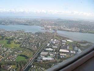
 Western part of the suburb seen from Mangere Domain. | |
 Mangere Bridge | |
| Coordinates: 36°56′36″S 174°47′5″E | |
| Country | New Zealand |
| Local authority | Auckland Council |
| Population (2013)[1] | |
| • Total | 5,952 |
| (Manukau Harbour) | (Manukau Harbour) | (Mangere Inlet) |
| (Manukau Harbour) |
|
Favona |
| (Manukau Harbour) | Māngere | Favona |
It includes Māngere Mountain and is close to the Ambury Farm Park run by the Auckland Council.[2]
It is a multicultural area, often with large families, with the suburb dominated by brick-and-tile homes built in the 1960s–1970s.[2]
In 2019, the name of the suburb was officially gazetted as Māngere Bridge.[3]
Marae
Te Puea Marae, the local marae, is a tribal meeting ground for the Waikato Tainui hapū of Ngāti Kuiaarangi, Ngāti Mahuta, Ngāti Tai and Ngāti Whāwhākia. It includes a meeting house, also called Te Puea.[4][5] The marae has helped hundreds of homeless people find housing, through a philosophy of manaakitanga.[6]
Association football
Mangere Bridge is home to Onehunga-Mangere United football club.
Notable residents
- David Lange ONZ CH – Former Prime Minister
- Hon Willie Jackson – Politician, Broadcaster
- Jon Zealando – Magician
- Mike King ONZM – Comedian and Mental Health Advocate
References
- 2013 Census QuickStats about a place : Mangere Bridge
- "Mangere – Property". The New Zealand Herald. 7 May 2005. Retrieved 7 February 2011.
- "Place name detail: Māngere Bridge". New Zealand Gazetteer. Land Information New Zealand. Retrieved 2 August 2019.
- "Te Kāhui Māngai directory". tkm.govt.nz. Te Puni Kōkiri.
- "Māori Maps". maorimaps.com. Te Potiki National Trust.
- Nielson, Michael (19 September 2018). "Te Puea Marae model of manaakitanga 'key' to tackling homelessness crisis". New Zealand Media and Entertainment. New Zealand Herald.
External links
- Mangere Bridge community site
- Mangere Bridge Business Community site
- Photographs of Māngere Bridge held in Auckland Libraries' heritage collections.