Lykketoppen
Lykketoppen,[1][2] occasionally anglicized as Lykke Peak, is a snow-covered, 765-meter (2,510 ft) tall summit that surmounts the southwest part of Bouvetøya, standing 1 nautical mile (2 km) east of Norvegia Point. It was first roughly charted in 1898 by a German expedition under Carl Chun, and was recharted and named in December 1927 by the First Norvegia Expedition under Captain Harald Horntvedt.[3]
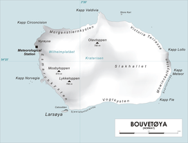
Map of Bouvetøya
References
- "Lykketoppen". Norwegian Polar Institute. Archived from the original on 12 May 2012. Retrieved 11 May 2012.
- Barr, Susan (1987). Norway's Polar Territories. Oslo: Aschehoug. p. 59. ISBN 82-03-15689-4.
- "Lykke Peak". Geographic Names Information System. Archived from the original on 12 May 2012. Retrieved 12 May 2012.
![]()
This article is issued from Wikipedia. The text is licensed under Creative Commons - Attribution - Sharealike. Additional terms may apply for the media files.