Lurøya, Nordland
Lurøya is an island in the municipality of Lurøy in Nordland county, Norway. The 14.2-square-kilometre (5.5 sq mi) island is located just west of the island of Stigen and just north of the island of Onøya. Lurøya has a bridge connection to Onøya. The village of Lurøy is located on Lurøya, and that is the administrative centre of the municipality. Lurøy Church is located on the southwest side of the island. The highest point on the island is the 685-metre (2,247 ft) tall mountain Lurøyfjellet. In 2017, there were 138 residents of the island.[1]
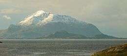 View of the mountain Lurøyfjellet on Lurøya | |
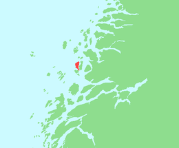 | |
 Lurøya Location of the island  Lurøya Lurøya (Norway) | |
| Geography | |
|---|---|
| Location | Nordland, Norway |
| Coordinates | 66.4187°N 12.8789°E |
| Area | 14.2 km2 (5.5 sq mi) |
| Length | 6 km (3.7 mi) |
| Width | 3.5 km (2.17 mi) |
| Highest elevation | 685 m (2,247 ft) |
| Highest point | Lurøyfjellet |
| Administration | |
Norway | |
| County | Nordland |
| Municipality | Lurøy Municipality |
| Demographics | |
| Population | 138 (2017) |
| Pop. density | 9.7/km2 (25.1/sq mi) |
See also
References
- Thorsnæs, Geir, ed. (2017-07-14). "Lurøya". Store norske leksikon (in Norwegian). Kunnskapsforlaget. Retrieved 2019-02-02.
This article is issued from Wikipedia. The text is licensed under Creative Commons - Attribution - Sharealike. Additional terms may apply for the media files.