Loch A'an
Loch A'an is a remote freshwater loch set deep within the central Cairngorms plateau, in the Cairngorms National Park, located in the eastern Highlands of Scotland.[1] Loch A'an, also called Loch Avon, is the source of the River Avon.[2] Loch A'an is oriented southwest-northeast and is bounded on three sides by precipitous mountains, cliffs and crags, with the North-East opening out to provide an outflow for the river through Glen Avon.
| Loch A'an | |
|---|---|
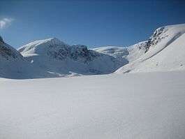
 A view towards the east end of the loch from Stacan Dubha. | |
| Location | Cairngorms, Grampian Mountains, Scotland |
| Coordinates | 57°6′12.36″N 3°37′37.68″W |
| Type | Natural freshwater lake |
| Primary outflows | River Avon |
| Basin countries | Scotland |
| Max. length | 4.8 km (3.0 mi) |
| Max. width | 0.29 km (0.18 mi) |
| Surface area | 0.43 km2 (0.17 sq mi) |
| Average depth | 77.27 ft (23.55 m) |
| Max. depth | 101 ft (31 m) |
| Shore length1 | 0.3 km (0.19 mi) [1] |
| Surface elevation | 725 m (2,379 ft)[1] |
| 1 Shore length is not a well-defined measure. | |
Geography
To the north of the loch, rising almost vertically, lies the Cairn Gorm, the sixth highest mountain in the United Kingdom. To the southwest of Cairn Gorm, at the head of the loch, lies the imposing peak of Ben Macdui, the second highest mountain in the UK, and to east lies Beinn Mheadhoin, the tenth highest mountain in the UK, again rising almost vertically from the Loch A'an basin. Lying 1.2 km (0.75 mi) south of the loch and 202 m (663 ft) feet higher up the range at 927 m (3,041 ft), lies Loch Etchachan.
References
- "Loch Avon/Loch A'an". British Lakes. Retrieved 1 January 2019.
- Gittings, Bruce; Munro, David. "Loch A'an". The Gazetteer for Scotland. University of Edinburgh and The Royal Scottish Geographical Society. Retrieved 1 January 2019.