Little Wabash River
The Little Wabash River is a 240-mile-long (390 km)[2][3] tributary of the Wabash River in east-central and southeastern Illinois in the United States. Via the Wabash and Ohio rivers, it is part of the watershed of the Mississippi River. It is the third largest tributary after the White River and the Embarras River.
| Little Wabash River | |
|---|---|
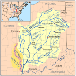 Map of the Little Wabash River highlighted within the Wabash River watershed | |
| Physical characteristics | |
| Source | |
| • location | Coles County west of Mattoon, Illinois |
| • coordinates | 39°28′31″N 88°27′30″W |
| Mouth | |
• location | Confluence with the Wabash River near New Haven, Illinois |
• coordinates | 37°53′27″N 88°05′40″W |
• elevation | 341 ft (104 m) |
| Length | 242 mi (389 km) |
| Discharge | |
| • location | Carmi, IL |
| • average | 2,978 cu/ft. per sec.[1] |
| Basin features | |
| Progression | Little Wabash → Wabash → Ohio → Mississippi → Gulf of Mexico |
| GNIS ID | 412430 |
| West Branch Little Wabash River | |
|---|---|
| Physical characteristics | |
| Source | |
| • location | Shelby County southeast of Windsor |
| • coordinates | 39°25′08″N 88°32′46″W |
| Mouth | |
• location | Confluence with the Little Wabash River, Shelby County, Illinois |
• coordinates | 39°17′49″N 88°32′45″W |
• elevation | 568 ft (173 m) |
| Basin features | |
| Progression | West Branch → Little Wabash → Wabash → Ohio → Mississippi → Gulf of Mexico |
| GNIS ID | 420792 |
- Note: The Little River of northeastern Indiana is also sometimes known as the Little Wabash River.
Course
The Little Wabash rises in Coles County near Mattoon and flows generally southwardly through Shelby, Effingham, Clay, Richland, Wayne, Edwards and White counties, past the towns of Louisville, Golden Gate, Carmi and New Haven. It enters the Wabash River on the common boundary of White and Gallatin counties, about 4 miles (6 km) southeast of New Haven.
In its upper course in Shelby County, the river is dammed to form Lake Mattoon and collects the short West Branch Little Wabash River, which flows for its entire length in Shelby County. Other tributaries include the Fox River, which joins it in Edwards County; the Elm River, which joins it in Wayne County; and the Skillet Fork, which joins it in White County.
See also
- List of Illinois rivers
- Watersheds of Illinois
References
- https://waterdata.usgs.gov/il/nwis/uv/?site_no=03381500&PARAmeter_cd=00065,00060
- U.S. Geological Survey Geographic Names Information System: Little Wabash River
- U.S. Geological Survey. National Hydrography Dataset high-resolution flowline data. The National Map Archived 2012-03-29 at the Wayback Machine, accessed May 19, 2011
- Columbia Gazetteer of North America entry
- DeLorme (2003). Illinois Atlas & Gazetteer. Yarmouth, Maine: DeLorme. ISBN 0-89933-321-4.
- U.S. Geological Survey Geographic Names Information System: West Branch
- Surfing the Little Wabash with USEPA
| Authority control |
|
|---|