List of scheduled monuments in South Kesteven
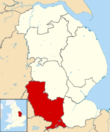
South Kesteven is a local government district in Lincolnshire, England, forming part of the traditional Kesteven division of the county. It includes Grantham, Stamford, Bourne and The Deepings and covers an area of 364 square miles (943 km2). The 2011 census reported a population of 133,788 people.[1] The administrative centre of the district is Grantham.
A scheduled monument is a nationally important archaeological site or monument which is given legal protection by being placed on a list (or "schedule") by the Secretary of State for Culture, Media and Sport; Historic England takes the leading role in identifying such sites. The legislation governing this is the Ancient Monuments and Archaeological Areas Act 1979. The term "monument" can apply to the whole range of archaeological sites, and they are not always visible above ground. Such sites have to have been deliberately constructed by human activity. They range from prehistoric standing stones and burial sites, through Roman remains and medieval structures such as castles and monasteries, to later structures such as industrial sites and buildings constructed for the World Wars or the Cold War.[2]
There are 92 scheduled monuments in South Kesteven.[3] Some of the oldest are Neolithic, Bronze Age or Iron Age including hill forts and bowl barrows. The Romano-British period is represented with several sites including the town of Ancaster and sections of major Roman engineering works such as the Car Dyke and Ermine Street. Religious sites are represented by Sempringham Priory, which was the founding location of the only purely English religious order, the Gilbertines;[4] the list also includes Witham Preceptory, a Knights Templar preceptory between North and South Witham, and several friaries in the ancient town of Stamford. More recent sites include several motte-and-bailey castles such as Bytham Castle and many village and churchyard standing crosses dating to the Middle Ages. The most recent monuments include two stone arch bridges built in the 16th and 17th centuries, and a village pump and milestone constructed near Normanton circa 1800.
Three of the sites are located in more than one jurisdiction. The Deeping Gate Bridge crosses the River Welland into Cambridgeshire, the Neolithic settlement site east of Uffington and Barnack station straddles the boundary between Lincolnshire and Cambridgeshire, and Kennulph's Stone is a tripoint boundary marker at the intersection of South Kesteven, South Holland and the City of Peterborough.
Except where noted, the monuments are listed below using the titles given in the Historic England data sheets.
Monuments
| Name | Location | Type | Completed [note 1] | Grid ref.[note 2] Geo-coordinates | Notes | Entry number [note 3] | Image | Ref. |
|---|---|---|---|---|---|---|---|---|
| Allington village cross | Allington | Standing cross | 15th century | SK 85680 40219 52°57′09″N 0°43′34″W |
Remains of a 15th century limestone cross. The base and socket stone are from the original cross; the lower shaft was added in the late 19th century and the upper shaft in the 20th century. The cross is a Grade II listed building. | 1012412 |  Allington village cross | [5][6] |
| Ancaster Roman settlement | Ancaster | Roman town | Romano-British | SK 98266 43502 52°58′48″N 0°32′16″W |
1st century Roman fort built on an earlier Iron Age settlement near the junction of Ermine Street and King Street. A town later grew around the site of the original fortification. | 1005004 |  Ancaster Roman settlement | [7][8][9][10] |
| Ancaster village cross | Ancaster | Standing cross | 14th century | SK 98405 43843 52°58′58″N 0°32′09″W |
Remains of a 14th century stone cross. The cross base is a Grade II listed building. | 1009222 |  Ancaster village cross | [11][12] |
| Area of medieval town by Barnhill House | Stamford | Medieval town | Middle Ages | TF 02733 07212 52°39′11″N 0°28′58″W |
Medieval town located near a spot where Ermine Street forded the River Welland, possibly founded as result of population displacement from the Romano-British settlement at Great Casterton. First mentioned in Anglo-Saxon records from the 7th century, in the late 9th/early 10th centuries it was one of the five Danish burhs. Later the site of a Norman castle and a medieval town wall. | 1004971 |  Area of medieval town by Barnhill House | [13] |
| Aslackby Castle | Aslackby | Moated enclosure | Middle Ages | TF 08532 30511 52°51′40″N 0°23′22″W |
Site of a moated enclosure and a possible fish pond, visible only from cropmarks. Now believed to be a manorial complex rather than a castle. | 1004952 |  Aslackby Castle | [14] |
| Austin Friars Priory | Stamford | Monastery | Middle Ages | TF 02516 06853 52°38′59″N 0°29′10″W |
Augustinian friary, founded 1343, on a site previously occupied by Friars of the Sack. The friary was dissolved in 1538. The only remaining aboveground traces are spoil heaps from a 1712 excavation of the site. Material from the priory, including a gargoyle, is believed to have been re-used in Hopkin's Hospital, a nearby 18th-century almshouse. | 1005054 |  Austin Friars Priory | [15][16][17] |
| Barrow SW of Stroxton, on parish boundary | Stroxton | Round barrow | Bronze Age | SK 88501 30758 52°52′01″N 0°41′12″W |
Barrow on parish boundary between Wyville cum Hungerton and Little Ponton and Stroxton, part of the Ponton Heath Barrow Cemetery. Visible only as a slight ridge less than .05 metres (2.0 in). The site has been added to the Heritage at Risk Register due to risk from arable ploughing. | 1004999 |  | [18][19][20] |
| Bassingthorpe Manor moated site | Bassingthorpe | Moated enclosure | Middle Ages | SK 96656 28435 52°50′41″N 0°33′59″W |
Moat at the former site of Bassingthorpe Manor. The house was moved in the 16th century to a site immediately north of the moat. | 1016475 | | [21] |
| Bennington Grange moated site | Long Bennington | Monastic grange | Middle Ages | SK 83734 40765 52°57′28″N 0°45′18″W |
Surviving traces of a monastic grange, including a moat and fish ponds. This site was used either for the support of an alien priory of Savigny Abbey located in nearby Long Bennington, or possibly the Gilbertine priory of St Catherine outside Lincoln. | 1018867 | | [22][23][24][note 4] |
| Bourne Castle | Bourne | Motte-and-bailey castle | Middle Ages | TF 09340 19899 52°45′56″N 0°22′51″W |
Earthworks remaining from a Norman motte and double bailey castle next to the Bourne Eau. The castle was built by Baldwin FitzGilbert at a site reputed to have been the home of Hereward the Wake and was destroyed after being used by Oliver Cromwell's troops in 1645. The area is now an open space known as Wellhead Park; the only apparent surviving above ground masonry are arrow slits in a building known as Shippon Barn. | 1005023 | [25][26][27][28] | |
| Bowl barrow 210m SSW of The Limes / Bowl barrow 220m south of The Limes | Horbling | Bowl barrow | Bronze Age | TF 117 346 52°53′52″N 0°20′25″W |
Two bowl barrows, separately scheduled, on either side of the Horbling to Billingborough road. The mounds apparently postdate the signs of ridge and furrow cultivation surrounding them and it is possible they are archery butts. | 1009988 1009997 |
| [29][30][31] |
| Bowl barrow 450m north west of St Guthlac's Church | Little Ponton | Bowl barrow | Bronze Age | SK 92242 32606 52°52′59″N 0°37′50″W |
Bowl barrow approximately 50 metres (160 ft) in diameter and 2 metres (6 ft 7 in) high. Could possibly be a spoil tip from a nearby gravel pit. | 1013900 |  Bowl barrow 450m north west of St Guthlac's Church | [32][33][34] |
| Brazenose College, Stamford | Stamford | Medieval university | 14th century | TF 03372 07320 52°39′14″N 0°28′24″W |
Site of a university founded by disaffected members of Brasenose College, Oxford in the early 14th century; suppressed by Edward III in 1334. The area is now occupied by the Stamford School. The school grounds, and the gate which originally included the door knocker which gave the college its name, are separately scheduled. The gate and retaining walls are listed as Grade I. | 1004972 1005008 |
 Brazenose College, Stamford | [note 5] [35][36][37][38] |
| Bronze Age saltern | Billingborough | Saltern | Bronze Age | TF 13249 33307 52°53′07″N 0°19′06″W |
Bronze Age saltern, visible as a mound and ditch. The site is one of the earliest known salt-making works in England. This monument has been placed on the Heritage at Risk Register due to the risk of animal burrowing. | 1004961 | | [39][40][41] |
| Car Dyke, south of Dyke | Dyke | Roman drainage system | Romano-British | TF 10505 21709 52°46′54″N 0°21′47″W |
Section of watercourse, previously thought to be a Roman canal, now proved to part of a fen drainage system. | 1004959 | [42] | |
| Careby Wood camp | Careby Aunby and Holywell | Hill fort | Iron Age | TF 04004 15601 52°43′41″N 0°27′41″W |
Iron Age multivallate hill fort. | 1003613 |  Careby Wood camp | [43] |
| Castle Bytham Castle, associated town defences and ponds | Castle Bytham | Motte-and-bailey castle | Middle Ages | SK 99040 18358 52°45′14″N 0°32′02″W |
11th century motte-and-bailey castle; destroyed by Henry III in 1221 during a rebellion by William de Fortibus. A second castle built on the site was destroyed in the 15th century during the Wars of the Roses. | 1014681 |  Castle Bytham Castle, associated town defences and ponds | [44][45] |
| Castle Dyke moated site | Aunby | Moated enclosure | Middle Ages | TF 00801 14255 52°43′00″N 0°30′33″W |
Manorial complex associated with the de Colville family of Castle Bytham. | 1019097 |  Castle Dyke moated site | [46] |
| Castle Hill | Hough-on-the-Hill | Motte-and-bailey castle | Middle Ages | SK 92403 46440 53°00′26″N 0°37′28″W |
Motte-and-bailey castle situated on a natural hill. The Saxon-built Church of All Saints lies within the precincts of the former bailey, as well as a school built in 1867. | 1003571 |  Castle Hill | [47] |
| Castle Hills ringwork and bailey | Heydour | Ringwork castle | Middle Ages | TF 00735 39704 52°56′43″N 0°30′08″W |
Ringwork castle with outer bailey and moat at the site of a manorial complex. | 1019977 | | [48] |
| Causewayed camp | Barholm | Causewayed enclosure | Neolithic | TF 09032 10280 52°40′45″N 0°23′19″W |
Cropmark traces of a prehistoric causewayed enclosure, consisting of two concentric circuits approximately 10 metres (33 ft) apart. | 1005486 | | [49] |
| Causewayed camp | Uffington | Causewayed enclosure | Neolithic | TF 05361 07967 52°39′33″N 0°26′37″W |
Cropmark traces of a prehistoric causewayed enclosure, consisting of two concentric circuits approximately 8 metres (26 ft) apart. The site has been placed on the Heritage at Risk Register due to the risk from arable ploughing. | 1004938 | | [50][51] |
| Churchyard cross, All Saints' churchyard | Westborough | Standing cross | 15th century | SK 85011 44283 52°59′21″N 0°44′06″W |
15th century limestone cross in the yard of All Saints' church. The cross is a Grade II listed building. | 1009211 |  Churchyard cross, All Saints' churchyard | [52][53] |
| Churchyard cross, St Andrew's churchyard | Denton | Standing cross | 14th century | SK 86534 32499 52°52′59″N 0°42′56″W |
Surviving base of 14th century limestone cross in the yard of St Andrew's church. The cross is a Grade II listed building. | 1009207 |  Churchyard cross, St Andrew's churchyard | [54][55] |
| Churchyard cross, St Mary's churchyard | Marston | Standing cross | 16th century | SK 89284 43704 52°59′00″N 0°40′18″W |
Medieval limestone cross in the yard of St Mary's church, converted to a sundial in the 16th century. The structure is a Grade II listed building. | 1009209 |  Churchyard cross, St Mary's churchyard | [56][57] |
| Churchyard cross, St Mary's churchyard | North Witham | Standing cross | 14th century | SK 92788 21864 52°47′11″N 0°37′32″W |
Surviving base of 14th century limestone cross in the yard of St Mary's church. The cross is a Grade II listed building. | 1009205 | | [58][59] |
| Churchyard cross, St Michael's churchyard | Edenham | Standing cross | 14th century | TF 06194 21804 52°47′00″N 0°25′37″W |
Surviving portion of 14th century limestone cross in the yard of St Michael's church. The cross is a Grade II listed building. | 1009202 | .jpg) Churchyard cross, St Michael's churchyard | [60][61] |
| Churchyard cross, St Nicholas' churchyard | Gunby | Standing cross | 14th century | SK 91274 21546 52°47′02″N 0°38′53″W |
Surviving portion of 14th century limestone cross in the yard of St Nicholas' church. The cross is a Grade II listed building. | 1009206 | | [62][63] |
| Churchyard cross, St Peter's churchyard | Claypole | Standing cross | 14th century | SK 84564 48974 53°01′53″N 0°44′26″W |
14th century limestone cross in the yard of St Peter's church, refurbished in the early 20th century as a memorial to World War I. The cross is a Grade II listed building. | 1011798 |  Churchyard cross, St Peter's churchyard | [64][65] |
| Churchyard cross, St Swithun's churchyard | Long Bennington | Standing cross | 16th century | SK 84355 43866 52°59′08″N 0°44′42″W |
Surviving portion of 16th century limestone cross in the yard of St Swithun's church. The cross is a Grade II listed building. | 1011800 |  Churchyard cross, St Swithun's churchyard | [66][67] |
| Churchyard cross, St Vincent's churchyard | Caythorpe | Standing cross | 14th century | SK 93889 48550 53°01′34″N 0°36′06″W |
Limestone cross in the yard of St Vincent's Church. The socket stone and a portion of the shaft date to the 14th century; the remainder is a 1906 restoration. The cross is a Grade II listed building. | 1009225 |  Churchyard cross, St Vincent's churchyard | [68][69] |
| Cistercian grange | Ropsley | Monastic grange | Middle Ages | SK 98617 36536 52°55′02″N 0°32′05″W |
Cropmark traces of a monastic grange used for the support of Vandey Abbey in Grimsthorpe. | 1005038 | | [70] |
| Conduit House, Market Place | Grantham | Water supply | 16th century | SK 91260 35917 52°54′47″N 0°38′40″W |
Marketplace water supply, originally installed by the Greyfriars in the 14th century. The present structure was built in 1597 and restored several times afterwards. The building is listed as Grade II. | 1005016 |  Conduit House, Market Place | [71][72] |
| Corby Glen market cross | Corby Glen | Market cross | 14th century | SK 99907 25009 52°48′48″N 0°31′09″W |
Market cross, originally built in the 14th century with alterations in the 18th and 20th centuries. The cross is a Grade II listed building. | 1009204 | .jpg) Corby Glen market cross | [73][74] |
| Corby Castle | Corby Glen | Moated motte | Middle Ages | SK 99990 25125 52°48′52″N 0°31′04″W |
Moated motte, sometimes referred to as Corby Castle, near the Church of St John the Evangelist. A surviving portion of the gatehouse southwest of the motte, separately scheduled, is now part of a Grade II-listed 18th-century barn. | 1004928 1005001 |
 Corby Castle | [note 6] [75][76] |
| Decoy pond 350m south of Aslackby Decoy Farm | Pointon and Sempringham | Decoy pond | post-Middle Ages | TF 14075 30802 52°51′45″N 0°18′25″W |
Decoy pond, visible as cropmarks, used for the trapping of waterfowl. | 1016472 |  Decoy pond 350m south of Aslackby Decoy Farm | [77] |
| Deeping Gate Bridge | between Deeping St James and Peterborough | Arch bridge | 17th century | TF 15069 09494 52°40′15″N 0°17′59″W |
Limestone arch bridge over the River Welland between Deeping St James and Peterborough. The bridge is a Grade II* listed building. | 1003767 |  Deeping Gate Bridge | [78] |
| Denton village cross | Denton | Standing cross | 14th century | SK 86594 32528 52°53′00″N 0°42′53″W |
Remains of 14th century limestone village cross, now in the front garden of Denton House (also known as Leys House, or The Leys). The cross is a Grade II listed building. | 1009213 | | [79][80] |
| Dovecote at Barholm Old Hall | Barholm | Dovecote | circa 1600 | TF 08862 10706 52°40′59″N 0°23′28″W |
Dovecote east of Barholm Old Hall. The structure is a Grade II* listed building. The structure has been placed on the Heritage at Risk Register due to the risk of collapse. | 1018683 | | [81][82][83] |
| Dunsby village cross | Dunsby | Standing cross | Middle Ages | TF 10587 26864 52°49′41″N 0°21′36″W |
Remains of medieval village cross, constructed of limestone. | 1009201 | | [84] |
| Earthworks of Car Dyke in Park Wood, 175m east of King Street (A15) | Thurlby | Roman drainage system | Romano-British | TF 10522 16116 52°43′53″N 0°21′53″W |
Segment of the Car Dyke, a Roman fen drainage system. | 1009999 |  Earthworks of Car Dyke in Park Wood, 175m east of King Street (A15) | [85] |
| Ermine Street, section S of Quarry Farm | Stamford | Roman road | Romano-British | TF 00979 07982 52°39′37″N 0°30′30″W |
Section of the Roman road Ermine Street, visible as earthworks and cropmarks, next to the old Great North Road. | 1005031 | | [86] |
| Five barrows NW of Heath Farm | Great Ponton | Round barrows | Bronze Age | SK 88693 30050 52°51′38″N 0°41′03″W |
Group of round barrows visible as cropmarks and slight earthworks, part of the Ponton Heath Barrow Cemetery. These are the survivors of a larger group, several of which were destroyed by ironstone quarrying in the 1950s. The site has been placed on the Heritage at Risk Register due to the risk from arable ploughing. | 1004998 | [18][87][88] | |
| Folkingham Castle | Folkingham | Ringwork and bailey castle | Middle Ages | TF 07487 33567 52°53′20″N 0°24′14″W |
Moated ringwork castle with bailey, later the site of a house of correction. | 1005021 | .jpg) Folkingham Castle | [89] |
| Fulbeck village cross | Fulbeck | Standing cross | 14th century | SK 94774 50378 53°02′32″N 0°35′16″W |
Village cross. The base dates to the 14th century, while the shaft and cross were added in a 19th-century restoration. The structure is a Grade II listed building. | 1009223 |  Fulbeck village cross | [90][91] |
| Gelston village cross | Gelston | Standing cross | 15th century | SK 91301 45324 52°59′51″N 0°38′28″W |
Remains of limestone village cross, located on the village green. The structure is a Grade II listed building. | 1009217 |  Gelston village cross | [92][93] |
| Grantham market cross | Grantham | Market cross | 13th century | SK 91291 35941 52°54′47″N 0°38′38″W |
Standing cross in Grantham marketplace. The base is believed to be medieval in origin while the remainder is from various 18th- to 20th century restorations. The structure is a Grade II listed building. | 1009212 | [94][95] | |
| Greyfriars Gate | Stamford | Gatehouse | 14th century | TF 03577 07457 52°39′18″N 0°28′13″W |
Surviving gatehouse of a Franciscan friary, founded before 1230 and dissolved in 1538. The grounds are now occupied by Stamford and Rutland Hospital. | 1005006 |  Greyfriars Gate | [note 7] [96] |
| Harlaxton village cross | Harlaxton | Standing cross | 14th century | SK 88446 32662 52°53′03″N 0°41′13″W |
Remains of a 14th century village cross, refurbished in the early 19th century. The structure is a Grade II listed building. | 1009208 |  Harlaxton village cross | [97][98] |
| The Hermitage moated site, 400m north east of Corby Pasture Farm | Irnham | Moated enclosure | Middle Ages | TF 01093 26466 52°49′35″N 0°30′04″W |
Medieval moated enclosure. Surviving traces include earthworks and a fish pond. | 1016969 |  The Hermitage moated site, 400m north east of Corby Pasture Farm | [99] |
| Honington camp | Honington | Hill fort | Iron Age | SK 95412 42335 52°58′12″N 0°34′51″W |
Iron Age multivallate hill fort, situated on a plateau. A hoard of Roman coins was discovered here in 1691. | 1005019 | .jpg) Honington camp | [100] |
| Iron Age and Roman settlement including a saltern on Hall Meadow | Deeping St James | Saltern | Iron Age and Romano-British | TF 16357 11484 52°41′19″N 0°16′48″W |
Saltern used in both Iron Age and Romano-British periods for salt production in The Fens. | 1009998 | | [101] |
| Iron Age settlement | Honington | Settlement | Iron Age | SK 94801 44352 52°59′17″N 0°35′21″W |
Iron Age, possible Roman, settlement visible only as cropmarks. The eastern portion of the site was destroyed by the now-abandoned Lincoln & Nottingham Railway. | 1004939 |  Iron Age settlement | [102] |
| Kenulph's stone, also called Kennulph's stone or St Kennulph's stone | Deeping St James, Crowland and Newborough | Tripoint boundary marker | Middle Ages, refurbished 1817 | TF 20980 09193 52°40′01″N 0°12′45″W |
Originally one of several crosses erected circa 1200 to mark the boundaries of Crowland Abbey and named after its first abbot. In 1817, a commission established to set the boundary between the Parts of Holland and Kesteven used the cross as the southernmost point of its boundary and placed a new stone on the old base. The structure is a Grade II listed building. | 1005040 |  Kenulph's stone, also called Kennulph's stone or St Kennulph's stone | [103][104] |
| Knights Templar preceptory, watermill and fishponds | Temple Hill, between North and South Witham | Knights Templar preceptory | Middle Ages | SK 92815 20556 52°46′29″N 0°37′32″W |
Knights Templar preceptory, founded in the 12th century and deserted in the 14th century when the order was suppressed. Excavation in the 1960s revealed traces of an extensive complex, including a watermill on the River Witham, fish ponds, and a forge. | 1007688 |  Knights Templar preceptory, watermill and fishponds | [105] |
| Medieval settlement remains at Shillingthorpe Park | Southwest of Braceborough | Settlement | Middle Ages | TF 07188 11394 52°41′23″N 0°24′56″W |
Abandoned medieval settlement on north bank of West Glen River. Includes earthwork traces of a moated enclosure and two furlongs of ridge and furrow cultivation. | 1018685 | | [106] |
| Moated site NE of Sempringham House Farm | Sempringham | Moated enclosure | Middle Ages | TF 12936 32968 52°52′56″N 0°19′23″W |
Moated enclosure, possibly a grange of Sempringham Priory. The Car Dyke passes through the site. | 1005013 | .jpg) Moated site NE of Sempringham House Farm | [107] |
| Norman arch at No 11 St Mary's Hill | Stamford | Postern gate | Middle Ages | TF 03030 06997 52°39′03″N 0°28′42″W |
12th-century arch, thought to be part of a postern gate in the town wall. The adjacent house, which incorporates the arch, is listed as Grade II. | 1005005 | .jpg) Norman arch at No 11 St Mary's Hill | [108][109] |
| Norman manor house | Boothby Pagnell | Manor house | Middle Ages | SK 97053 30660 52°51′53″N 0°33′35″W |
Surviving portion of Norman manor house with 16th- to 19th-century alterations. The structure is a Grade I listed building. | 1005055 | 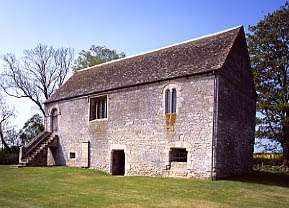 Norman manor house | [110][111] |
| Pump and milestone | Normanton | Village pump and milestone | 18th or 19th century | SK 94901 46358 53°00′22″N 0°35′14″W |
Village pump and milestone on the main Grantham to Lincoln road. The structure is a Grade II listed building. | 1004929 | .jpg) Pump and milestone | [112][113] |
| Ring Dam medieval fishpond | Ropsley | Fish pond | Middle Ages | SK 99690 33756 52°53′31″N 0°31′11″W |
Medieval fish pond on East Glen River, first mentioned in sources in 1335. The northern portion was infilled by 1843, and a portion was diverted to a sheep wash. | 1019976 |  Ring Dam medieval fishpond | [114] |
| Rippingale village cross | Rippingale | Standing cross | 14th century | TF 09855 27823 52°50′12″N 0°22′14″W |
Surviving portion of 14th century limestone village cross. The structure is a Grade II listed building. | 1009200 | | [115][116] |
| Roman marching camp | Ancaster | Roman marching camp | Romano-British | SK 97953 44520 52°59′21″N 0°32′32″W |
Roman marching camp, or castra, located northwest of the present village of Ancaster. The site has been placed on the Heritage at Risk Register due to the risk from arable ploughing. | 1004958 | | [117][118] |
| Roman settlement and drove at Fen Farm | Horbling | Roman settlement and drove | Romano-British | TF 16525 34526 52°53′44″N 0°16′09″W |
Romano-British settlement of at least five farmsteads, built on a wide roddon in The Fens. The site is also the junction of two droves. | 1013482 | | [119] |
| Roman settlement by Fen Road, south of Poplar Farm | Pointon and Sempringham | Roman settlement and drove | Romano-British | TF 15817 31375 52°52′03″N 0°16′51″W |
Romano-British settlement of two or three farmsteads, built on a wide roddon in The Fens. The site is also the location of a livestock drove. | 1010000 | | [120] |
| Roman site, Priors Meadow | Deeping St James | Roman settlement | Romano-British | TF 16959 09621 52°40′18″N 0°16′18″W |
Site of a possible Roman settlement east of Deeping St James. Fragments of a Roman bronze ritual crown, as well as 2nd-century Samian ware fragments, were found here in the 1960s. The site has been placed on the Heritage at Risk Register due to the risk from arable ploughing. | 1004985 |  Roman site, Priors Meadow | [121][122] |
| Round Hills earthwork | Ingoldsby | Earthworks | Iron Age, possibly medieval | SK 99188 30787 52°51′56″N 0°31′41″W |
Mound of uncertain date, possible an Iron Age univallate hill fort or medieval enclosure. Finds at the site include worked flint and Roman pottery, and old aerial photographs showed signs of ridge and furrow cultivation. | 1005039 |  Round Hills earthwork | [123] |
| Old St James' Church | Woolsthorpe-by-Belvoir | Church | Middle Ages | SK 83729 32986 52°53′16″N 0°45′25″W |
Medieval church, destroyed in 1643 by Roundheads during the siege of Belvoir Castle. The cemetery remains, though the church is only a pile of rubble. | 1003679 |  Old St James' Church | [124] |
| St Leonard's Priory | Stamford | Monastery | Middle Ages | TF 03883 07297 52°39′12″N 0°27′57″W |
Benedictine priory, founded in the 12th century as a cell of Durham Cathedral and dissolved in 1538. A part of the nave and north arcade survives and is a Grade I listed building. | 1007690 | [125][126] | |
| St Michael's Priory rere-dorter | Stamford | Reredorter | Middle Ages | TF 02787 06471 52°38′46″N 0°28′56″W |
A reredorter, or latrine; the only surviving portion of a large Benedictine nunnery founded in the 12th century and dissolved in 1536. Forms part of an underground chamber beneath Stamford Junior School. | 1007811 | | [127] |
| St Peter's Church | Stamford | Church | Middle Ages | TF 02723 07025 52°39′04″N 0°28′59″W |
Site of church mentioned in the Domesday Book. The building was raided by Lancastrian forces during the Wars of the Roses; demolished in 1560 when its parish was amalgamated with All Saints'. | 1004974 | .jpg) St Peter's Church | [128] |
| Saucer barrow 100m west of All Saints' Church | Westborough | Saucer barrow | Bronze Age | SK 84918 44301 52°59′22″N 0°44′11″W |
Rare example of a saucer barrow dating to the Early Bronze Age. | 1013899 |  Saucer barrow 100m west of All Saints' Church | [129] |
| Saxon cross in churchyard of parish church, South Stoke | Stoke Rochford | Standing cross | Middle Ages | SK 92005 27335 52°50′08″N 0°38′08″W |
Three portions of stone crosses with Anglo-Saxon carvings discovered when the village of North Stoke was demolished in the 19th century. Re-erected in churchyard of St Andrew and St Mary. | 1005014 | | [130] |
| Sempringham Priory | Sempringham | Gilbertine priory | Middle Ages | TF 10399 32386 52°52′39″N 0°21′40″W |
Founding priory of the Gilbertine Order, established in the 12th century and dissolved in 1538. Surviving traces include a fish pond complex and the priory church, now the parish church of St Andrew, a Grade I listed building. Other structures on the site include a tithe barn and holy well, both listed as Grade II. | 1005481 | [131][132][133][134] | |
| Settlements on Rippingale Fen | Rippingale | Romano-British settlement | Romano-British | TF 15623 28282 52°50′23″N 0°17′06″W |
Two adjacent areas, separately scheduled, containing cropmark traces of a Romano-British settlement. Findings include pottery and quern-stones. The sites have been placed on the Heritage at Risk Register due to the risk from arable ploughing. | 1004976 1004977 |
.jpg) Settlements on Rippingale Fen | [note 8] [135][136][137] |
| Settlement site at Greatford | Greatford | Iron Age or Roman settlement | Iron Age or Romano-British | TF 08943 11520 52°41′26″N 0°23′23″W |
Cropmark traces of several ditched enclosures, prehistoric or Romano-British in date. The site has been placed on the Heritage at Risk Register due to the risk from arable ploughing. | 1004957 | | [138][139] |
| Settlement site E of Greatford village | Greatford | Iron Age or Roman settlement | Iron Age or Romano-British | TF 09797 11937 52°41′38″N 0°22′37″W |
Cropmark traces of several ditched enclosures, prehistoric or Romano-British in date. The site has been placed on the Heritage at Risk Register due to the risk from arable ploughing. | 1004934 | | [140][141][142] |
| Settlement site E of Uffington and Barnack Station | between Uffington and Barnack | Neolithic, Bronze Age, Iron Age, and Roman settlement | Neolithic to Bronze Age | TF 07971 06411 52°38′41″N 0°24′20″W |
Extensive complex of ancient buildings dating from the late Neolithic, including round barrows, a cursus, and hengiform monuments. The site also has traces of later occupation, including a Roman villa. | 1006792 | .jpg) Settlement site E of Uffington and Barnack Station | [143] |
| Site discovered by aerial photography NE of village | Northeast of Barholm | Roman farmstead or villa | Romano-British | TF 09476 11411 52°41′22″N 0°22′54″W |
Cropmark traces of a Roman farmstead or villa. Pottery fragments from the site date to the 4th century. | 1005480 | | [144] |
| Shrunken medieval village | Sapperton | Shrunken medieval village | Middle Ages | TF 02140 33878 52°53′34″N 0°29′00″W |
Traces of medieval desertion east of the present village of Sapperton, including earthworks and signs of ridge and furrow cultivation. | 1005483 | .jpg) Shrunken medieval village | [145] |
| Stamford Castle | Stamford | Motte-and-bailey castle | Middle Ages | TF 02833 06982 52°39′03″N 0°28′53″W |
11th century Norman motte-and-bailey castle, possibly built on site of an earlier Anglo-Saxon fortification. Demolished in 1484. Surviving traces include a small section of the Great Hall and a postern gate, both listed as Grade II. | 1005011 |  Stamford Castle | [146][147][148] |
| Swinstead village cross | Swinstead | Standing cross | 14th century | TF 01820 22490 52°47′25″N 0°29′30″W |
Remnant of 14th century limestone village cross. The structure is a Grade II listed building. | 1009203 |  Swinstead village cross | [149][150] |
| Tower Hill motte castle, Stainby | Stainby | Motte castle | Middle Ages | SK 90962 22689 52°47′39″N 0°39′09″W |
Earthwork remains of 11th century Norman motte castle. | 1019527 | | [151] |
| Stamford town wall | Stamford | Defensive wall | Middle Ages | TF 02526 06998 52°39′04″N 0°29′09″W |
Two sections of town wall, separately scheduled. An intact bastion on West Street is a Grade I listed building, while a section of wall on North Street is listed Grade II. The remnants of two southern bastions on Wharf Street are listed Grade II but not scheduled. | 1005007 1005482 |
[note 9] [152][153][154][155][156][157][158][159] | |
| Uffington Bridge | Uffington | Arch bridge | 16th or 17th century | TF 06631 06926 52°38′59″N 0°25′31″W |
Stone arch bridge over the River Welland. The structure is a Grade II* listed building. | 1004997 | .jpg) Uffington Bridge | [160][161] |
| Village cross, Towngate | Market Deeping | Standing cross | 14th century | TF 13298 10797 52°40′59″N 0°19′32″W |
Remaining fragments of 14th century standing cross. The structure is a Grade II listed building. | 1009219 | | [162][163] |
| Village cross and lock-up, Deeping St James | Deeping St James | Standing cross converted to village lock-up. | 15th century, converted 19th century | TF 15807 09490 52°40′59″N 0°19′32″W |
Originally a 15th century standing cross, converted in 1819 to a village lock-up. The structure is a Grade I listed building. | 1009220 | .jpg) Village cross and lock-up, Deeping St James | [164][165] |
| Westborough village cross | Westborough | Standing cross | 15th century | SK 85103 44650 52°59′33″N 0°44′01″W |
Surviving limestone base of village cross. The structure is a Grade II listed building. | 1009210 | .jpg) Westborough village cross | [166][167] |
| Whitefriars Priory | Stamford | Monastery | 13th century | TF 03484 07330 52°39′14″N 0°28′18″W |
Site of a Carmelite friary founded in 1268 and dissolved in 1538. A surviving section of wall at the southwest corner of the compound is listed as Grade II. | 1004973 | | [note 7] [168][169] |
.jpg)

.jpg)
.jpg)


.jpg)
See also
| Wikimedia Commons has media related to Scheduled ancient monuments in South Kesteven District. |
- Scheduled Monuments in Lincolnshire
- Grade I listed buildings in South Kesteven
- Grade II* listed buildings in South Kesteven
Notes
- The date given is the date used by Historic England as significant for the initial building or that of an important part in the structure's description.
- Sometimes known as OSGB36, the grid reference is based on the British national grid reference system used by the Ordnance Survey.
- The "List Entry Number" is a unique number assigned to each listed building and scheduled monument by Historic England.
- Historic England and PastScape state that this site was a grange of Long Bennington Priory; the Lincolnshire County Council states this was a grange of St Catherine's.
- This entry was created by combining two entries from the National Heritage List for England—"Site of Brazenose College (1004972)" and "Brasenose Gate (1005008)".
- This entry was created by combining two entries from the National Heritage List for England—"Remains of medieval gatehouse (1004928)" and "Corby moated mound (1005001)".
- PastScape notes that the sites of the Stamford Greyfriars and Whitefriars friaries have typically been reversed in previous references. This is reflected in the National Heritage List for England, which has the sites confused.
- This entry was created by combining two entries from the National Heritage List for England—"Settlement between Rippingale Running Dike and Long Drove (1004976)" and "Settlement between Long Drove and Dowsby Drain (1004977)".
- This entry was created by combining two entries from the National Heritage List for England—"Tower of city wall, West Street (1005007)" and "Site of town defences (North Street) (1005482)".
References
- "Key Figures for 2011 Census: Key Statistics". 2011 census. Office for National Statistics. Retrieved 3 November 2015.
- "Scheduled Monuments". Historic England. Retrieved 3 November 2015.
- "Listed buildings". South Kesteven District Council. Retrieved 3 November 2015.
- Butler, Richard Urban (1909). "Order of Gilbertines". The Catholic Encyclopedia. 6 (1909 ed.). New York: Robert Appleton Company.
- Historic England. "Allington village cross (1012412)". National Heritage List for England. Retrieved 27 October 2015.
- Historic England. "Cross (Grade II) (1062904)". National Heritage List for England. Retrieved 27 October 2015.
- Historic England. "Causennae Roman Town (325933)". PastScape. Retrieved 28 October 2015.
- "Iron Age Settlement, Ancaster". Historic Environment Record. Lincolnshire County Council. Retrieved 9 March 2015.
- "Possible Roman Camp, Ancaster". Historic Environment Record. Lincolnshire County Council. Retrieved 9 March 2015.
- "Ancaster Roman Settlement". Historic Environment Record. Lincolnshire County Council. Retrieved 9 March 2015.
- Historic England. "Ancaster village cross (1009222)". National Heritage List for England. Retrieved 27 October 2015.
- Historic England. "Cross base (Grade II) (1062423)". National Heritage List for England. Retrieved 27 October 2015.
- Historic England. "Stamford (348052)". PastScape. Retrieved 28 October 2015.
- Historic England. "Aslackby Castle (348717)". PastScape. Retrieved 28 October 2015.
- Historic England. "Stamford Austin Friary (347905)". PastScape. Retrieved 28 October 2015.
- Historic England. "Hopkin's Hospital (Grade II) (1306216)". National Heritage List for England. Retrieved 4 November 2015.
- "Hopkins Hospital, St Peter's Street, Stamford". Historic Environment Record. Lincolnshire County Council. Retrieved 4 November 2015.
- Historic England. "Monument No. 323820". PastScape. Retrieved 30 October 2015.
- "Barrow south west of Stroxton". Historic Environment Record. Lincolnshire County Council. Retrieved 5 November 2015.
- "Barrow south west of Stroxton, on parish boundary". Heritage at Risk. Historic England. Retrieved 28 October 2015.
- Historic England. "Bassingthorpe Manor moated site (1016475)". National Heritage List for England. Retrieved 28 October 2015.
- Historic England. "Bennington Grange moated site (1018867)". National Heritage List for England. Retrieved 28 October 2015.
- Historic England. "Long Bennington Grange (324035)". PastScape. Retrieved 28 October 2015.
- "Bennington Grange Moated Site". Historic Environment Record. Lincolnshire County Council. Retrieved 8 March 2016.
- Historic England. "Bourne Castle (348162)". PastScape. Retrieved 28 October 2015.
- "Bourne Castle". Historic Environment Record. Lincolnshire County Council. Retrieved 8 March 2016.
- Historic England. "Shippon Barn to north of Well Head Cottage (Grade II) (1241937)". National Heritage List for England. Retrieved 8 March 2016.
- Historic England. "Well Head Cottage (Grade II) (1260271)". National Heritage List for England. Retrieved 8 March 2016.
- Historic England. "Monument No. 350966". PastScape. Retrieved 28 October 2015.
- "One of two mounds which may have been archery butts". Historic Environment Record. Lincolnshire County Council. Retrieved 8 November 2015.
- "One of two mounds which may have been archery butts". Historic Environment Record. Lincolnshire County Council. Retrieved 8 November 2015.
- Historic England. "Monument No. 325739". PastScape. Retrieved 28 October 2015.
- Historic England. "Bowl barrow 450m north west of St Guthlac's Church (1013900)". National Heritage List for England. Retrieved 28 October 2015.
- "Possible bowl barrow 450 m north west of St Guthlac's Church, Little Ponton". Historic Environment Record. Lincolnshire County Council. Retrieved 8 November 2015.
- Historic England. "Brazenose College (347866)". PastScape. Retrieved 28 October 2015.
- "Brasenose College gate, St Paul's Street, Stamford". Historic Environment Record. Lincolnshire County Council. Retrieved 8 March 2016.
- "Site of Brazenose College, Stamford". Historic Environment Record. Lincolnshire County Council. Retrieved 8 March 2016.
- Historic England. "Brazenose College Gate, Retaining walls of College (Grade I) (1360017)". National Heritage List for England. Retrieved 28 October 2015.
- Historic England. "Monument No. 892487". PastScape. Retrieved 28 October 2015.
- "Late Bronze Age to early Iron Age salt making site, Billingborough". Historic Environment Record. Lincolnshire County Council. Retrieved 8 March 2016.
- "Bronze Age saltern, Billingborough - South Kesteven". Heritage at Risk. Historic England. Retrieved 28 October 2015.
- Historic England. "Car Dyke (1034975)". PastScape. Retrieved 28 October 2015.
- Historic England. "Monument No. 348223". PastScape. Retrieved 28 October 2015.
- Historic England. "Castle Bytham (325283)". PastScape. Retrieved 29 October 2015.
- Historic England. "Castle Bytham Castle, associated town defences and ponds (1014681)". National Heritage List for England. Retrieved 29 October 2015.
- Historic England. "Castle Dyke moated site (1019097)". National Heritage List for England. Retrieved 29 October 2015.
- Historic England. "Castle Hill (325849)". PastScape. Retrieved 29 October 2015.
- Historic England. "Castle Hills ringwork and bailey (1019977)". National Heritage List for England. Retrieved 29 October 2015.
- Historic England. "Barholm causewayed enclosure (348267)". PastScape. Retrieved 29 October 2015.
- Historic England. "Uffington causewayed enclosure (347828)". PastScape. Retrieved 29 October 2015.
- "Causewayed camp, Uffington - South Kesteven". Heritage at Risk. Historic England. Retrieved 28 October 2015.
- Historic England. "Churchyard cross, All Saints' churchyard (1009211)". National Heritage List for England. Retrieved 29 October 2015.
- Historic England. "Cross 3 meters to south of Church of All Saints (Grade II) (1253496)". National Heritage List for England. Retrieved 29 October 2015.
- Historic England. "Churchyard cross, St Andrew's churchyard (1009207)". National Heritage List for England. Retrieved 29 October 2015.
- Historic England. "Base of churchyard cross, south of Church of St Andrew (Grade II) (1147460)". National Heritage List for England. Retrieved 29 October 2015.
- Historic England. "Churchyard cross, St Mary's churchyard (1009209)". National Heritage List for England. Retrieved 29 October 2015.
- Historic England. "Sundial 6m south of porch of Church of St. Mary (Grade II) (1360091)". National Heritage List for England. Retrieved 29 October 2015.
- Historic England. "Churchyard cross, St Mary's churchyard (1009205)". National Heritage List for England. Retrieved 29 October 2015.
- Historic England. "Cross in churchyard of Church of St. Mary (Grade II) (1062317)". National Heritage List for England. Retrieved 29 October 2015.
- Historic England. "Churchyard cross, St Michael's churchyard (1009202)". National Heritage List for England. Retrieved 30 October 2015.
- Historic England. "Churchyard cross 5 metres south west of Church St. Michael (Grade II) (1146650)". National Heritage List for England. Retrieved 30 October 2015.
- Historic England. "Churchyard cross, St Nicholas' churchyard (1009206)". National Heritage List for England. Retrieved 30 October 2015.
- Historic England. "Churchyard cross at south side of Church of St. Nicholas (Grade II) (1062352)". National Heritage List for England. Retrieved 30 October 2015.
- Historic England. "Churchyard cross, St Peter's churchyard (1011798)". National Heritage List for England. Retrieved 30 October 2015.
- Historic England. "Cross in churchyard to the south east of church (Grade II) (1146726)". National Heritage List for England. Retrieved 30 October 2015.
- Historic England. "Churchyard cross, St Swithun's churchyard (1011800)". National Heritage List for England. Retrieved 30 October 2015.
- Historic England. "Cross 5m to south of Church of St. Swithin (Grade II) (1146873)". National Heritage List for England. Retrieved 30 October 2015.
- Historic England. "Churchyard cross, St Vincent's churchyard (1009225)". National Heritage List for England. Retrieved 30 October 2015.
- Historic England. "Churchyard cross (Grade II) (1062434)". National Heritage List for England. Retrieved 30 October 2015.
- Historic England. "Ropsley Grange (325563)". PastScape. Retrieved 30 October 2015.
- Historic England. "Monument No. 1464026". PastScape. Retrieved 30 October 2015.
- Historic England. "The conduit, (on west side at end of Conduit Lane (Grade II) (1253690)". National Heritage List for England. Retrieved 30 October 2015.
- Historic England. "Corby Glen market cross (1009204)". National Heritage List for England. Retrieved 30 October 2015.
- Historic England. "Market cross (Grade II) (1062818)". National Heritage List for England. Retrieved 30 October 2015.
- Historic England. "Monument No. 325412". PastScape. Retrieved 30 October 2015.
- Historic England. "Barn to Church Farmhouse (Grade II) (1165913)". National Heritage List for England. Retrieved 1 November 2015.
- Historic England. "Decoy pond 350m south of Aslackby Decoy Farm (1016472)". National Heritage List for England. Retrieved 30 October 2015.
- Historic England. "Bridge, over the River Welland (Grade II*) (1360154)". National Heritage List for England. Retrieved 30 October 2015.
- Historic England. "Denton village cross (1009213)". National Heritage List for England. Retrieved 30 October 2015.
- Historic England. "Stone cross in garden immediately north west of The Leys (Grade II) (1062369)". National Heritage List for England. Retrieved 30 October 2015.
- Historic England. "Dovecote at Barholm Old Hall (1018683)". National Heritage List for England. Retrieved 30 October 2015.
- Historic England. "Pigeoncote to Barholm Old Hall (Grade II*) (1062369)". National Heritage List for England. Retrieved 30 October 2015.
- "Dovecote at Barholm Old Hall, Barholm and Stowe". Heritage at Risk. Historic England. Retrieved 28 October 2015.
- Historic England. "Dunsby village cross (1009201)". National Heritage List for England. Retrieved 30 October 2015.
- Historic England. "Earthworks of Car Dyke in Park Wood, 175m east of King Street (A15) (1009999)". National Heritage List for England. Retrieved 30 October 2015.
- Historic England. "Ermine Street (1031856)". PastScape. Retrieved 30 October 2015.
- "Five barrows north west of Heath Farm, Great Ponton". Historic Environment Record. Lincolnshire County Council. Retrieved 5 November 2015.
- "Five barrows north west of Heath Farm, Great Ponton". Heritage at Risk. Historic England. Retrieved 28 October 2015.
- Historic England. "Folkingham Castle (348708)". PastScape. Retrieved 30 October 2015.
- Historic England. "Fulbeck village cross (1009223)". National Heritage List for England. Retrieved 30 October 2015.
- Historic England. "Cross base and shaft (Grade II) (1360293)". National Heritage List for England. Retrieved 30 October 2015.
- Historic England. "Gelston village cross (1009217)". National Heritage List for England. Retrieved 30 October 2015.
- Historic England. "Cross (Grade II) (1146907)". National Heritage List for England. Retrieved 30 October 2015.
- Historic England. "Grantham market cross (1009212)". National Heritage List for England. Retrieved 30 October 2015.
- Historic England. "Market cross (Grade II) (1062499)". National Heritage List for England. Retrieved 30 October 2015.
- Historic England. "Stamford Greyfriars (347913)". PastScape. Retrieved 31 October 2015.
- Historic England. "Harlaxton village cross (1009208)". National Heritage List for England. Retrieved 30 October 2015.
- Historic England. "Village cross (Grade II) (1236812)". National Heritage List for England. Retrieved 30 October 2015.
- Historic England. "The Hermitage moated site, 400m north east of Corby Pasture Farm (1016969)". National Heritage List for England. Retrieved 30 October 2015.
- Historic England. "Honington Camp (325900)". PastScape. Retrieved 31 October 2015.
- Historic England. "Iron Age and Roman settlement including a saltern on Hall Meadow (1009998)". National Heritage List for England. Retrieved 31 October 2015.
- Historic England. "Monument No. 326073". PastScape. Retrieved 31 October 2015.
- Historic England. "St Kennulphs stone (351978)". PastScape. Retrieved 31 October 2015.
- Historic England. "Kennulphs stone (Grade II) (1064551)". National Heritage List for England. Retrieved 31 October 2015.
- Historic England. "Remains of Knights Templar preceptory, watermill and fishponds (1007688)". National Heritage List for England. Retrieved 31 October 2015.
- Historic England. "Medieval settlement remains at Shillingthorpe Park (1018685)". National Heritage List for England. Retrieved 31 October 2015.
- Historic England. "Monument No. 351012". PastScape. Retrieved 31 October 2015.
- Historic England. "Monument No. 348009". PastScape. Retrieved 31 October 2015.
- Historic England. "11, St Mary's Hill (Grade II) (1062958)". National Heritage List for England. Retrieved 31 October 2015.
- Historic England. "Boothby Hall (325707)". PastScape. Retrieved 31 October 2015.
- Historic England. "Boothby manor house (Grade I) (1360056)". National Heritage List for England. Retrieved 31 October 2015.
- Historic England. "Monument No. 325899". PastScape. Retrieved 1 November 2015.
- Historic England. "Pump and milestone (Grade II) (1062378)". National Heritage List for England. Retrieved 1 November 2015.
- Historic England. "Ring Dam medieval fishpond (1019976)". National Heritage List for England. Retrieved 1 November 2015.
- Historic England. "Rippingale village cross (1009200)". National Heritage List for England. Retrieved 1 November 2015.
- Historic England. "Cross (Grade II) (1241286)". National Heritage List for England. Retrieved 1 November 2015.
- Historic England. "Ancaster Roman temporary camp (326008)". PastScape. Retrieved 1 November 2015.
- "Roman marching camp, Ancaster". Heritage at Risk. Historic England. Retrieved 28 October 2015.
- Historic England. "Roman settlement and drove at Fen Farm (1013482)". National Heritage List for England. Retrieved 1 November 2015.
- Historic England. "Roman settlement by Fen Road, south of Poplar Farm (1010000)". National Heritage List for England. Retrieved 1 November 2015.
- Historic England. "Monument No. 350114". PastScape. Retrieved 1 November 2015.
- "Roman site, Priors Meadow, Deeping St. James". Heritage at Risk. Historic England. Retrieved 1 November 2015.
- Historic England. "Round Hills (325713)". PastScape. Retrieved 1 November 2015.
- Historic England. "St James church (323846)". PastScape. Retrieved 1 November 2015.
- Historic England. "Ruins and site of St Leonard's Priory (1007690)". National Heritage List for England. Retrieved 1 November 2015.
- Historic England. "Remains of St Leonard's Priory (Grade I) (1062210)". National Heritage List for England. Retrieved 1 November 2015.
- Historic England. "St Michael's Priory rere-dorter (1007811)". National Heritage List for England. Retrieved 1 November 2015.
- Historic England. "St Peters church (347843)". PastScape. Retrieved 2 November 2015.
- Historic England. "Saucer barrow 100m west of All Saints' Church (1013899)". National Heritage List for England. Retrieved 1 November 2015.
- Historic England. "Monument No. 325451". PastScape. Retrieved 2 November 2015.
- Historic England. "Sempringham Priory (350974)". PastScape. Retrieved 2 November 2015.
- Historic England. "Church of St Andrew (Grade I) (1241280)". National Heritage List for England. Retrieved 2 November 2015.
- Historic England. "Barn to west of church (Grade II) (1260599)". National Heritage List for England. Retrieved 2 November 2015.
- Historic England. "Well (Grade II) (1241280)". National Heritage List for England. Retrieved 2 November 2015.
- Historic England. "Monument No. 350540". PastScape. Retrieved 2 November 2015.
- "Settlement between Long Drove and Dowsby Drain, Rippingale". Heritage at Risk. Historic England. Retrieved 2 November 2015.
- "Settlement between Rippingale Running Dike and Long Drove, Rippingale". Heritage at Risk. Historic England. Retrieved 2 November 2015.
- Historic England. "Monument No. 1036342". PastScape. Retrieved 2 November 2015.
- "Settlement site at Greatford". Heritage at Risk. Historic England. Retrieved 2 November 2015.
- Historic England. "Monument No. 1036335". PastScape. Retrieved 2 November 2015.
- Historic England. "Monument No. 1036349". PastScape. Retrieved 2 November 2015.
- "Settlement site east of Greatford village, Greatford". Heritage at Risk. Historic England. Retrieved 2 November 2015.
- Historic England. "Monument No. 347770". PastScape. Retrieved 2 November 2015.
- Historic England. "Monument No. 348258". PastScape. Retrieved 2 November 2015.
- Historic England. "Sapperton (348756)". PastScape. Retrieved 2 November 2015.
- Historic England. "Stamford Castle (347832)". PastScape. Retrieved 2 November 2015.
- Historic England. "Outhouses at corner of Castle Dyke (Grade II) (1308487)". National Heritage List for England. Retrieved 2 November 2015.
- Historic England. "Postern gate of castle. Section of castle wall (Grade II) (1062284)". National Heritage List for England. Retrieved 2 November 2015.
- Historic England. "Swinstead village cross (1009203)". National Heritage List for England. Retrieved 2 November 2015.
- Historic England. "Cross (Grade II) (1147041)". National Heritage List for England. Retrieved 2 November 2015.
- Historic England. "Tower Hill motte castle, Stainby (1019527)". National Heritage List for England. Retrieved 2 November 2015.
- Historic England. "Monument No. 904693". PastScape. Retrieved 2 November 2015.
- Historic England. "Bastion (Grade I) (1360072)". National Heritage List for England. Retrieved 2 November 2015.
- Historic England. "Monument No. 347829". PastScape. Retrieved 2 November 2015.
- Historic England. "Town wall to north of North Walk House (Grade II) (1062903)". National Heritage List for England. Retrieved 2 November 2015.
- Historic England. "Monument No. 904687". PastScape. Retrieved 2 November 2015.
- Historic England. "Remains of bastion of town wall (Grade II) (1170422)". National Heritage List for England. Retrieved 2 November 2015.
- Historic England. "Monument No. 904700". PastScape. Retrieved 2 November 2015.
- Historic England. "5, Wharf Road (Grade II) (1062899)". National Heritage List for England. Retrieved 2 November 2015.
- Historic England. "Uffington Bridge (892601)". PastScape. Retrieved 2 November 2015.
- Historic England. "Bridge over River Welland (Grade II*) (1317255)". National Heritage List for England. Retrieved 2 November 2015.
- Historic England. "Village cross, Towngate (1009219)". National Heritage List for England. Retrieved 2 November 2015.
- Historic England. "Cross (Grade II) (1165462)". National Heritage List for England. Retrieved 2 November 2015.
- Historic England. "Village cross and lock-up, Deeping St James (1009220)". National Heritage List for England. Retrieved 2 November 2015.
- Historic England. "Village cross (Grade I) (1062681)". National Heritage List for England. Retrieved 2 November 2015.
- Historic England. "Westborough village cross (1009210)". National Heritage List for England. Retrieved 2 November 2015.
- Historic England. "Cross opposite Manor Farm (Grade II) (1253450)". National Heritage List for England. Retrieved 2 November 2015.
- Historic England. "Stamford Whitefriars (347874)". PastScape. Retrieved 31 October 2015.
- Historic England. "Wall of former Grey (sic) Friary fronting Priory Road and Brazenose Lane (Grade II) (1062211)". National Heritage List for England. Retrieved 31 October 2015.