List of listed buildings in Liff And Benvie, Angus
List
| Name | Location | Date Listed | Grid Ref. [note 1] | Geo-coordinates | Notes | LB Number [note 2] | Image |
|---|---|---|---|---|---|---|---|
| Liff, Liff Primary School (Later Building), Including Boundary Walls | 56°29′06″N 3°04′28″W | Category C(S) | 13212 |  | |||
| Liff, Parish Church, Hearse House | 56°29′00″N 3°05′04″W | Category B | 13215 |  | |||
| Muirhead Of Liff, Coupar Angus Road, Lundie And Muirhead Church, Lundie And Muirhead War Memorial | 56°29′51″N 3°04′15″W | Category C(S) | 13221 | | |||
| Balruddery, West Coach House/Steading | 56°28′39″N 3°06′52″W | Category C(S) | 10857 | | |||
| Birkhill, Coupar Angus Road, Browhead Cottage | 56°29′32″N 3°02′55″W | Category C(S) | 50077 | | |||
| Liff, Lossie Hall, Including Boundary Walls | 56°29′09″N 3°04′32″W | Category C(S) | 13213 | | |||
| Liff, Parish Church Including Churchyard, Boundary Walls And Gatepiers, And Old Font | 56°28′58″N 3°05′04″W | Category B | 13214 | 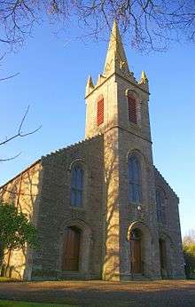 | |||
| Muirhead Of Liff, Coupar Angus Road, Muirhead School (Later Building), Including Playsheds, Boundary Wall And Gatepiers | 56°29′51″N 3°04′19″W | Category B | 13223 | | |||
| Balruddery, East Lodge | 56°28′25″N 3°06′26″W | Category C(S) | 10855 | | |||
| Benvie, Benvie Farmhouse, Including Outbuildings And Boundary Walls | 56°28′14″N 3°05′39″W | Category B | 10863 | | |||
| Liff, 8 Church Road, Former Manse, Including Coach House/Stable/Steading, And Boundary Walls | 56°29′03″N 3°04′58″W | Category B | 13209 | | |||
| Liff 9 Fowlis Road, The Cottage, Including Boundary Walls | 56°29′09″N 3°05′12″W | Category C(S) | 13210 | | |||
| Liff, Parish Church, Watt/Webster Memorial | 56°28′59″N 3°05′05″W | Category B | 13217 | | |||
| Muirhead Of Liff, Coupar Angus Road, Lundie And Muirhead Church, Including Gatepier And Boundary Walls | 56°29′51″N 3°04′16″W | Category C(S) | 13220 | | |||
| Balruddery, East Gates, Including Gatepiers, Quadrants And Adjoining Walls | 56°28′25″N 3°06′25″W | Category A | 10854 | | |||
| Liff, Parish Church, War Memorial | 56°28′59″N 3°05′04″W | Category B | 13216 | | |||
| Muirhead Of Liff, 147 Coupar Angus Road, The Old Schoolhouse | 56°29′51″N 3°04′14″W | Category C(S) | 13224 | | |||
| Balruddery, Wester Balruddery | 56°28′38″N 3°07′09″W | Category B | 10860 | | |||
| Balruddery, Balruddery Farm, Road Bridge Over Blacklaw Burn, North Of Balruddery Farm | 56°29′10″N 3°07′45″W | Category C(S) | 10859 | | |||
| Liff, Gray Cottage | 56°28′56″N 3°05′01″W | Category C(S) | 12860 | | |||
| Balruddery, Balruddery Farm, Farmhouse, Including Boundary Walls | 56°28′59″N 3°07′57″W | Category B | 10858 | | |||
| Little Dronley, Road Bridge Over Dichty Water | 56°30′16″N 3°04′00″W | Category C(S) | 13219 | | |||
| Birkhill 170 Coupar Angus Road Rose Cottage Including Boundary Walls | 56°29′39″N 3°03′26″W | Category C(S) | 12857 | | |||
| Balruddery, East Stable Court/Steading | 56°28′40″N 3°06′50″W | Category C(S) | 10856 | | |||
| Liff, Corner Of Church And Woodside Road, The Neuk, (Formerly Liff Inn) | 56°29′08″N 3°05′06″W | Category B | 13208 | | |||
| Liff, Liff Primary School And School House (Original Building), Including Boundary Walls | 56°29′04″N 3°04′28″W | Category C(S) | 13211 | | |||
| Liff, Wild Acres, Old Manse | 56°28′56″N 3°05′03″W | Category B | 13218 | | |||
| Muirhead Of Liff, Muirhead School (Original Building), Including Boundary Walls | 56°29′53″N 3°04′16″W | Category C(S) | 13222 | | |||
| Balruddery, Wester Balruddery, Ice House | 56°28′36″N 3°07′05″W | Category C(S) | 10861 | |
Key
The scheme for classifying buildings in Scotland is:
- Category A: "buildings of national or international importance, either architectural or historic; or fine, little-altered examples of some particular period, style or building type."[1]
- Category B: "buildings of regional or more than local importance; or major examples of some particular period, style or building type, which may have been altered."[1]
- Category C: "buildings of local importance; lesser examples of any period, style, or building type, as originally constructed or moderately altered; and simple traditional buildings which group well with other listed buildings."[1]
In March 2016 there were 47,288 listed buildings in Scotland. Of these, 8% were Category A, and 50% were Category B, with the remaining 42% being Category C.[2]
See also
Notes
- Sometimes known as OSGB36, the grid reference (where provided) is based on the British national grid reference system used by the Ordnance Survey.
• "Guide to National Grid". Ordnance Survey. Retrieved 2007-12-12.
• "Get-a-map". Ordnance Survey. Retrieved 2007-12-17. - Historic Environment Scotland assign a unique alphanumeric identifier to each designated site in Scotland, for listed buildings this always begins with "LB", for example "LB12345".
References
- All entries, addresses and coordinates are based on data from Historic Scotland. This data falls under the Open Government Licence
- "What is Listing?". Historic Environment Scotland. Retrieved 29 May 2018.
- Scotland's Historic Environment Audit 2016 (PDF). Historic Environment Scotland and the Built Environment Forum Scotland. pp. 15–16. Retrieved 29 May 2018.
This article is issued from Wikipedia. The text is licensed under Creative Commons - Attribution - Sharealike. Additional terms may apply for the media files.