List of listed buildings in Edinburgh/25
List
| Name | Location | Date Listed | Grid Ref. [note 1] | Geo-coordinates | Notes | LB Number [note 2] | Image |
|---|---|---|---|---|---|---|---|
| 3-9 (Odd Nos) Rose Street, Including The Abbotsford Bar | 55°57′12″N 3°11′41″W | Category B | 30151 | 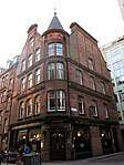 | |||
| 4 And 5 St Andrew Square | 55°57′12″N 3°11′34″W | Category B | 30158 |  | |||
| Saxe-Coburg Street 13-15A | 55°57′38″N 3°12′28″W | Category B | 30174 | | |||
| Slateford Road, Slateford Maltings | 55°55′52″N 3°14′14″W | Category B | 30184 | | |||
| Summer Place 1-5 | 55°57′50″N 3°12′08″W | Category B | 30185 | | |||
| 1 Waverley Park, Elsie Inglis Nursery, (Former Outpatients' Department) | 55°57′18″N 3°09′58″W | Category B | 30201 | | |||
| 4 Lauriston Gardens, St Catherine's Church (Roman Catholic) And Convent, Including Retaining Walls, Gatepiers And Gate | 55°56′39″N 3°11′57″W | Category B | 30205 | | |||
| Granton Harbour, Eastern Breakwater | 55°59′10″N 3°13′04″W | Category B | 30220 | | |||
| 1 - 12 Barclay Terrace (Inclusive Nos), 49 Barclay Place And 26 And 26A Wright's Houses | 55°56′23″N 3°12′15″W | Category B | 30065 | 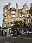 | |||
| 1, 2, 3, Belford Road And 1-5 (Inclusive Nos) Bells Brae, Former Drumsheugh Toll | 55°57′08″N 3°12′56″W | Category B | 30066 | 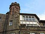 | |||
| 32, 32A, 32B And 32C Broughton Street | 55°57′28″N 3°11′23″W | Category B | 30069 | | |||
| 32 Cockburn Street | 55°57′02″N 3°11′22″W | Category B | 30089 | | |||
| 52-56 (Even Nos) Cockburn Street | 55°57′01″N 3°11′19″W | Category B | 30094 | 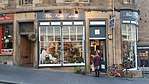 | |||
| 94 And 94A George Street And 82 Rose Street Lane North | 55°57′08″N 3°12′08″W | Category B | 30109 | | |||
| 96 Grassmarket | 55°56′53″N 3°11′42″W | Category C(S) | 30114 | | |||
| Hamilton Place 28, 34 | 55°57′30″N 3°12′28″W | Category B | 30115 | | |||
| 106-110 (Even Nos) Lauriston Place, Including Railings | 55°56′41″N 3°12′02″W | Category B | 30124 | | |||
| 8 And 8A York Place, Including Railings | 55°57′22″N 3°11′33″W | Category A | 29977 | | |||
| 16 York Place, Including Railings | 55°57′23″N 3°11′30″W | Category A | 29981 | | |||
| 20 York Place, Including Railings And Lamps | 55°57′23″N 3°11′29″W | Category A | 29983 | | |||
| St Bernard's Davidson Church Henderson Row | 55°57′35″N 3°12′18″W | Category B | 30016 | | |||
| 55 Lauriston Place, Chalmers Hospital, Including Boundary Wall, Railings And Lodge | 55°56′40″N 3°11′54″W | Category B | 30022 |  | |||
| Bank Street (Corner Market Street), Black Watch (South African War) Memorial | 55°57′00″N 3°11′40″W | Category A | 30034 | 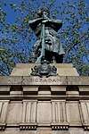 | |||
| 26 Viewforth, Boroughmuir High School, Including Boundary Walls, Gatepiers, Gates And Railings | 55°56′18″N 3°12′32″W | Category B | 30040 | 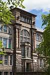 | |||
| 98-102 (Even Nos) West Bow | 55°56′54″N 3°11′40″W | Category B | 29909 | | |||
| 4 And 4A West Coates, Including Boundary Walls, Gatepiers And Obelisk | 55°56′46″N 3°13′45″W | Category B | 29920 | | |||
| 24-26 (Inclusive Nos) West Harbour Road | 55°58′55″N 3°13′46″W | Category C(S) | 29926 | | |||
| 51 York Place, Including Railings | 55°57′22″N 3°11′20″W | Category A | 29970 | | |||
| 66 East Trinity Road, Mary Cottage, With Boundary Wall, Railings And Gates | 55°58′33″N 3°12′13″W | Category B | 29859 | | |||
| 18 And 19 Union Place | 55°57′26″N 3°11′09″W | Category B | 29860 | | |||
| 4-10 (Even Nos) Union Street | 55°57′27″N 3°11′09″W | Category B | 29864 | | |||
| 4 Upper Bow | 55°56′56″N 3°11′38″W | Category C(S) | 29866 | 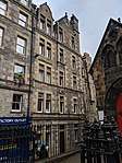 | |||
| 11, 13, 15 Walker Street | 55°56′58″N 3°12′47″W | Category A | 29879 |  | |||
| 20-24A (Even Nos) Scotland Street, Including Railings | 55°57′36″N 3°11′44″W | Category B | 29783 | | |||
| 9, 10, 11 South College Street | 55°56′49″N 3°11′12″W | Category B | 29799 |  | |||
| 17 Spring Gardens, St Ann's Bank House, Including Boundary Wall And Gatepiers | 55°57′19″N 3°09′50″W | Category B | 29801 | | |||
| 1 Spylaw Bank Road With Boundary Wall | 55°54′31″N 3°15′24″W | Category C(S) | 29817 | | |||
| 51 Spylaw Street With Boundary Wall | 55°54′28″N 3°15′23″W | Category C(S) | 29827 | | |||
| 2-18 (Even Nos) St Stephen Street, And 23, 24 North West Circus Place, Including Railings | 55°57′27″N 3°12′26″W | Category B | 29747 | | |||
| 23-29 (Odd Nos) Salisbury Road, Including Boundary Walls And Gatepiers | 55°56′18″N 3°10′32″W | Category B | 29755 | | |||
| Saxe Coburg Street 8-12 | 55°57′38″N 3°12′27″W | Category B | 29770 | | |||
| 12 Dean Bank Lane And Saxe Coburg Street, Deanbank House With Boundary Wall | 55°57′36″N 3°12′29″W | Category B | 29771 | | |||
| 30 And 31 Rutland Square, Including Railings And Lamp Standards | 55°56′57″N 3°12′33″W | Category A | 29691 | | |||
| 25 St Andrew Square With Railings | 55°57′18″N 3°11′37″W | Category B | 29702 | | |||
| 38 And 39 St Andrew Square, Bank Of Scotland With Lamp Standards | 55°57′15″N 3°11′30″W | Category A | 29707 |  | |||
| St Bernard's Row 18 | 55°57′34″N 3°12′39″W | Category B | 29721 | | |||
| 1, 2 Rothesay Terrace | 55°57′05″N 3°12′59″W | Category B | 29667 | | |||
| 17, 18 Rothesay Terrace | 55°57′01″N 3°13′08″W | Category C(S) | 29672 | | |||
| 1 And 3 Roxburgh Place, Including Railings | 55°56′50″N 3°11′05″W | Category B | 29674 | | |||
| 62 Restalrig Road South, Restalrig | 55°57′28″N 3°08′56″W | Category B | 29627 | | |||
| 152 And 154 Rose Street, Kenilworth Bar, And 112-114 (Even Nos) Rose Street Lane South | 55°57′06″N 3°12′08″W | Category A | 29651 | 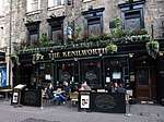 | |||
| 190-192 (Even Nos) Rose Street And Rose Street South Lane Edc Cleansing Store | 55°57′05″N 3°12′17″W | Category B | 29653 | | |||
| 49, 49A, 50 And 50A Queen Street | 55°57′14″N 3°12′10″W | Category A | 29559 | | |||
| 52 And 53 Queen Street With Railings | 55°57′14″N 3°12′11″W | Category A | 29561 | | |||
| 19-25 (Odd Numbers) Raeburn Place | 55°57′32″N 3°12′40″W | Category C(S) | 29580 | | |||
| 11 And 12 Ramsay Garden | 55°56′57″N 3°11′49″W | Category A | 29595 | | |||
| 49 Northumberland Street | 55°57′24″N 3°12′01″W | Category A | 29480 | | |||
| 4 Pentland Road With Boundary Wall | 55°54′31″N 3°15′54″W | Category B | 29487 | | |||
| 3 Pier Place And 1 Lamb's Court | 55°58′51″N 3°11′43″W | Category B | 29490 | | |||
| 1 Pilrig Place And 2-6 (Even Nos) Pilrig Street | 55°57′49″N 3°10′43″W | Category A | 29493 | | |||
| 127 And 128 Princes Street | 55°57′03″N 3°12′17″W | Category B | 29515 | | |||
| West Princes Street Gardens, The Cottage | 55°57′05″N 3°11′50″W | Category C(S) | 29525 | | |||
| Quality Street 29, 31 Davidson's Mains, Woodside Cottage | 55°57′51″N 3°16′25″W | Category B | 29529 | | |||
| 22 Queen Street With Railings And Garaging To Lane | 55°57′17″N 3°11′56″W | Category A | 29544 | | |||
| Nicolson Street West 17-19 | 55°56′42″N 3°11′07″W | Category B | 29434 | | |||
| Nicolson Street West 18-22 With Archway At Site Formerly Gray's Court, Former Southern Market Buildings And Old Market Bar | 55°56′41″N 3°11′05″W | Category B | 29438 | | |||
| Old Church Lane, Glen Arthur, Duddingston | 55°56′30″N 3°08′48″W | Category B | 29463 | | |||
| 5 And 7 Nelson Street, Including Railings And Lamp | 55°57′25″N 3°11′45″W | Category A | 29384 | | |||
| 15, 17 And 17A Nelson Street, And 6-7A Northumberland Place, Including Railings And Lamps | 55°57′26″N 3°11′46″W | Category A | 29386 | | |||
| 12-14 (Inclusive Nos) Nicolson Square, University Of Edinburgh, Alison House Including Railings | 55°56′46″N 3°11′11″W | Category B | 29414 | | |||
| Nicolson Street 104 | 55°56′41″N 3°11′01″W | Category B | 29425 | | |||
| 16, 17 And 18 Minto Street, Including Boundary Walls And Pedestrian Gate | 55°56′07″N 3°10′31″W | Category B | 29348 | | |||
| 32 And 33 Minto Street, Including Boundary Walls And Pedestrian Gate | 55°56′03″N 3°10′31″W | Category B | 29355 | | |||
| 34 Minto Street, Including Boundary Walls And Pedestrian Gate | 55°56′04″N 3°10′31″W | Category B | 29356 | | |||
| 35 And 36 Minto Street, Including Pedestrian Gate And Boundary Walls | 55°56′07″N 3°10′34″W | Category B | 29357 | | |||
| Montague Street, 7 - 57 And 75-79 St Leonard's Street | 55°56′33″N 3°10′46″W | Category B | 29366 | | |||
| 6-8 (Even Nos) Morrison Street And 112-116 (Even Nos) Lothian Road | 55°56′46″N 3°12′21″W | Category C(S) | 29375 | | |||
| 1, 1A And 3 Middleby Street, Including Boundary Walls And Pedestrian Gate | 55°56′06″N 3°10′33″W | Category B | 29331 | | |||
| 9A And B Middleby Street, Including Boundary Walls And Pedestrian Gate | 55°56′05″N 3°10′35″W | Category B | 29333 | | |||
| 1 Minto Street, Including Boundary Walls | 55°56′14″N 3°10′39″W | Category C(S) | 29336 | | |||
| 9 Minto Street Including Boundary Walls, Piers, And Pedestrian Gates | 55°56′11″N 3°10′35″W | Category B | 29342 | | |||
| 10 Minto Street, Including Boundary Walls And Pedestrian Gate | 55°56′10″N 3°10′35″W | Category C(S) | 29343 | | |||
| Marshall Street 14-20 (Even Nos) | 55°56′44″N 3°11′11″W | Category B | 29305 | | |||
| 37-45 (Odd Nos) Lothian Road | 55°56′53″N 3°12′22″W | Category C(S) | 29264 | | |||
| 105-117 (Odd Nos) Lothian Road | 55°56′46″N 3°12′18″W | Category C(S) | 29269 | | |||
| 119-123 (Odd Nos) Lothian Road And 5 Bread Street | 55°56′46″N 3°12′18″W | Category B | 29270 | | |||
| 14-20 (Even Nos) Keir Street, Including Boundary Wall And Railings | 55°56′44″N 3°11′50″W | Category B | 29199 | | |||
| Lanark Road, 502 Mount Pleasant, Juniper Green | 55°54′17″N 3°16′57″W | Category C(S) | 29208 | | |||
| 435 Lawnmarket, Including Deacon Brodie's Tavern And Part Of 451 Lawnmarket To Rear | 55°56′59″N 3°11′35″W | Category A | 29227 | %2C_Edinburgh.jpg) | |||
| 475-479 (Odd Nos) Lawnmarket | 55°56′58″N 3°11′37″W | Category B | 29232 | | |||
| 491-495 (Odd Nos) Lawnmarket, And 3 And 5 James Court | 55°56′58″N 3°11′38″W | Category A | 29234 | | |||
| 23-27A (Odd Nos) India Street, Including Railings And Lamps | 55°57′21″N 3°12′20″W | Category A | 29130 | | |||
| 16 India Street, Including Railings | 55°57′19″N 3°12′22″W | Category A | 29134 | | |||
| 1-5 (Odd Nos) Gloucester Place And 44 India Street, Including Railings And Lamps | 55°57′23″N 3°12′24″W | Category A | 29141 | | |||
| Inverleith Place, 21-25 | 55°58′04″N 3°12′30″W | Category B | 29149 | | |||
| Inverleith Row 46, 47 | 55°58′10″N 3°12′28″W | Category C(S) | 29179 | | |||
| 39, 41 Jeffrey Street, Lauder House, Including Boundary Wall | 55°57′04″N 3°11′08″W | Category B | 29190 | | |||
| 12 Hill Square Including Wall And Railings | 55°56′48″N 3°11′01″W | Category B | 29079 | | |||
| 21 And 23 Hill Street | 55°57′12″N 3°12′11″W | Category A | 29082 | | |||
| 11-37 (Odd Nos) Holyrood Road, University Of Edinburgh, Moray House, Paterson's Land | 55°57′00″N 3°10′46″W | Category B | 29090 | | |||
| 160 Canongate And Sugarhouse Close, Former Holyrood Brewery Including Malt Barn, Kilns, Brewhouse, Offices And Boundary Wall | 55°57′01″N 3°10′45″W | Category C(S) | 29091 | | |||
| 6-10 (Even Nos) Hope Street | 55°57′02″N 3°12′31″W | Category A | 29093 | | |||
| 9 And 9A Howe Street, Including Railings | 55°57′21″N 3°12′06″W | Category B | 29108 | | |||
| 15 And 17 Howe Street, Including Railings | 55°57′22″N 3°12′06″W | Category B | 29110 | | |||
| 4-10 (Even Nos) Howe Street, Including Railings | 55°57′21″N 3°12′08″W | Category B | 29115 | | |||
| 26 Howe Street | 55°57′23″N 3°12′10″W | Category B | 29119 | | |||
| High Street, 3 And 5 Old Fishmarket Close | 55°56′58″N 3°11′22″W | Category B | 29041 | | |||
| 44 And 46 High Street | 55°57′01″N 3°11′08″W | Category B | 29065 | | |||
| 156-166 (Even Nos) High Street | 55°56′59″N 3°11′20″W | Category B | 29071 | | |||
| 168-184 (Even Nos) High Street | 55°56′59″N 3°11′22″W | Category B | 29072 |  | |||
| 4 And 6 Grove Street, Including Railings | 55°56′45″N 3°12′47″W | Category B | 28981 | | |||
| 29-33 (Odd Nos) Hanover Street | 55°57′10″N 3°11′48″W | Category B | 28997 | | |||
| 14-18 (Even Nos) Hanover Street | 55°57′09″N 3°11′49″W | Category B | 29005 | | |||
| 3, 5 And 7 Grassmarket | 55°56′49″N 3°11′54″W | Category B | 28933 |  | |||
| 8 And 8A South Gray Street, Including Gatepiers And Boundary Walls | 55°56′02″N 3°10′36″W | Category B | 28948 | | |||
| 1 Upper Gray Street And 21 Salisbury Place, Including Boundary Walls And Pedestrian Gate | 55°56′13″N 3°10′45″W | Category B | 28950 | | |||
| 6-11 (Inclusive Nos) Glenfinlas Street, Including Railings And Lamps | 55°57′10″N 3°12′35″W | Category A | 28922 | | |||
| 69 And 69A George Street | 55°57′12″N 3°12′01″W | Category A | 28844 |  | |||
| 115 George Street With Railings | 55°57′09″N 3°12′16″W | Category A | 28854 | | |||
| 117 To 121 George Street, Church Of Scotland Offices | 55°57′10″N 3°12′17″W | Category A | 28855 |  | |||
| 135 George Street | 55°57′08″N 3°12′22″W | Category B | 28859 | | |||
| 60 And 60A George Street | 55°57′11″N 3°11′58″W | Category B | 28872 | | |||
| 84 George Street, Northern Lighthouse Board, With Railings | 55°57′09″N 3°12′06″W | Category A | 28877 | | |||
| 86 And 86A George Street | 55°57′09″N 3°12′07″W | Category B | 28879 | | |||
| 12 And 12A Forth Street | 55°57′29″N 3°11′16″W | Category B | 28775 | | |||
| 57-61 (Odd Nos) Frederick Street With Railings | 55°57′15″N 3°12′03″W | Category B | 28787 | | |||
| 40 And 42 Frederick Street, Victoria Chambers | 55°57′12″N 3°12′04″W | Category B | 28793 | | |||
| 44-46 (Even Nos) Frederick Street | 55°57′12″N 3°12′04″W | Category B | 28794 | | |||
| 1-4 (Inclusive Nos) Forrest Hill | 55°56′46″N 3°11′30″W | Category B | 28771 | .jpg) | |||
| 4 Dublin Street, Including Railings | 55°57′21″N 3°11′37″W | Category A | 28688 | | |||
| 40-46 (Even Nos) Dublin Street, Including Railings | 55°57′27″N 3°11′39″W | Category B | 28694 | | |||
| Deanhaugh Street 2-10 And 1 And 1A Dean Terrace | 55°57′29″N 3°12′34″W | Category A | 28650 | | |||
| Craiglockhart Park 1 Dunderach | 55°55′01″N 3°14′31″W | Category B | 28602 | | |||
| 15 And 17 Cockburn Street | 55°57′03″N 3°11′26″W | Category B | 28573 | | |||
| 25 Cockburn Street | 55°57′03″N 3°11′25″W | Category B | 28576 | | |||
| 17-39 (Odd Nos) Cowgate | 55°56′53″N 3°11′34″W | Category C(S) | 28594 | | |||
| Clarence Street 28-32 And 91-93 St Stephen Street | 55°57′31″N 3°12′20″W | Category B | 28542 | | |||
| 45 Claremont Road, Claremont House, With Garage Outbuilding, Boundary Wall, Gatepiers And Lamp Bracket | 55°58′04″N 3°09′20″W | Category B | 28543 | | |||
| Clerk Street South 76-84 | 55°56′23″N 3°10′49″W | Category C(S) | 28557 | | |||
| 30-32 (Inclusive Nos) North West Circus Place, Including Railings | 55°57′26″N 3°12′27″W | Category B | 28522 | | |||
| 53-63 (Odd Nos) Canongate, Whitefoord House And Callander House (Scottish Veteran's Residence) Including Hall, Lodges At 142 And 144 Calton Road, Tenements At 57, 59 & 61 Canongate, Boundary Walls, Gatepiers And Gates | 55°57′10″N 3°10′36″W | Category B | 28428 |  | |||
| 95 Canongate, Reid's Court, Canongate Manse Including Boundary Walls And Gatepiers | 55°57′08″N 3°10′39″W | Category A | 28429 |  | |||
| 115 Canongate, Panmure House (Little Lochend Close) Including Boundary Walls | 55°57′08″N 3°10′42″W | Category A | 28431 | | |||
| 140 Canongate, Acheson House | 55°57′04″N 3°10′45″W | Category A | 28446 |  | |||
| 6 And 8 Castle Street | 55°57′05″N 3°12′12″W | Category B | 28470 | | |||
| 13 Castle Terrace And 1 Cambridge Street, Including Boundary Wall And Railings | 55°56′53″N 3°12′18″W | Category B | 28484 |  | |||
| 46 Bruntsfield Place Including Boundary Walls | 55°56′21″N 3°12′19″W | Category B | 28375 |  | |||
| Buccleuch Place 12, 13 | 55°56′33″N 3°11′11″W | Category B | 28385 | | |||
| Buccleuch Place 17-19 | 55°56′33″N 3°11′14″W | Category A | 28387 | 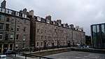 | |||
| 73-77 Buccleuch Street | 55°56′33″N 3°11′03″W | Category C(S) | 28394 | |
Key
The scheme for classifying buildings in Scotland is:
- Category A: "buildings of national or international importance, either architectural or historic; or fine, little-altered examples of some particular period, style or building type."[1]
- Category B: "buildings of regional or more than local importance; or major examples of some particular period, style or building type, which may have been altered."[1]
- Category C: "buildings of local importance; lesser examples of any period, style, or building type, as originally constructed or moderately altered; and simple traditional buildings which group well with other listed buildings."[1]
In March 2016 there were 47,288 listed buildings in Scotland. Of these, 8% were Category A, and 50% were Category B, with the remaining 42% being Category C.[2]
Notes
- Sometimes known as OSGB36, the grid reference (where provided) is based on the British national grid reference system used by the Ordnance Survey.
• "Guide to National Grid". Ordnance Survey. Retrieved 12 December 2007.
• "Get-a-map". Ordnance Survey. Retrieved 17 December 2007. - Historic Environment Scotland assign a unique alphanumeric identifier to each designated site in Scotland, for listed buildings this always begins with "LB", for example "LB12345".
References
- All entries, addresses and coordinates are based on data from Historic Scotland. This data falls under the Open Government Licence
- "What is Listing?". Historic Environment Scotland. Retrieved 29 May 2018.
- Scotland's Historic Environment Audit 2016 (PDF). Historic Environment Scotland and the Built Environment Forum Scotland. pp. 15–16. Retrieved 29 May 2018.
This article is issued from Wikipedia. The text is licensed under Creative Commons - Attribution - Sharealike. Additional terms may apply for the media files.