List of listed buildings in Edinburgh/15
List
| Name | Location | Date Listed | Grid Ref. [note 1] | Geo-coordinates | Notes | LB Number [note 2] | Image |
|---|---|---|---|---|---|---|---|
| Carlton Street 4-16 | 55°57′25″N 3°12′39″W | Category A | 28459 |  | |||
| 39-43 (Odd Nos) North Castle Street With Railings | 55°57′11″N 3°12′12″W | Category A | 28464 | | |||
| 57-61 (Odd Nos) North Castle Street With Railings | 55°57′13″N 3°12′13″W | Category A | 28467 | | |||
| 42-46 (Even Nos) North Castle Street With Railings And Lamp Standard | 55°57′11″N 3°12′16″W | Category A | 28477 | | |||
| 13-24 (Inclusive Nos) Brunton Place And 1 Brunton Terrace | 55°57′28″N 3°10′24″W | Category B | 28374 | | |||
| 55 And 56 Bruntsfield Place Including Boundary Walls | 55°56′19″N 3°12′20″W | Category B | 28377 | | |||
| 65 Bruntsfield Place Including Boundary Walls | 55°56′19″N 3°12′20″W | Category B | 28378 | | |||
| Buccleuch Place 4 | 55°56′34″N 3°11′07″W | Category B | 28380 | | |||
| Buccleuch Place 30-35 | 55°56′35″N 3°11′10″W | Category B | 28391 | | |||
| 10,12 Buccleuch Street | 55°56′36″N 3°11′07″W | Category B | 28398 | | |||
| 20 And 22 Calton Hill Including Railings, Gatepiers And Boundary Wall | 55°57′16″N 3°11′09″W | Category B | 28408 | | |||
| 2-7 (Inclusive Nos) Cambridge Street, Including Boundary Wall And Railings | 55°56′53″N 3°12′18″W | Category B | 28413 | 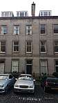 | |||
| 58-64 (Even Nos) Candlemaker Row | 55°56′50″N 3°11′32″W | Category C(S) | 28419 | | |||
| 50-54 (Even Nos) Candlemaker Row | 55°56′50″N 3°11′31″W | Category B | 28420 | | |||
| 7 And 9 Brighton Street | 55°56′47″N 3°11′23″W | Category B | 28352 | | |||
| 15 North Bank Street | 55°56′59″N 3°11′40″W | Category A | 28265 | | |||
| 16 North Bank Street | 55°56′59″N 3°11′40″W | Category A | 28266 | | |||
| 17 Blacket Place, Including Boundary Walls | 55°56′09″N 3°10′26″W | Category B | 28303 | | |||
| 2, 4 Alva Street, 15, 17 Queensferry Street | 55°57′03″N 3°12′36″W | Category A | 28238 | | |||
| 28, 30, 32 Alva Street Including Railings | 55°57′01″N 3°12′40″W | Category A | 28240 | | |||
| Annandale Street, Central Garage (Lothian Region Transport) | 55°57′40″N 3°11′17″W | Category B | 28251 | | |||
| 2-7 (Inclusive Nos) Abercromby Place, Including Railings And Lamp | 55°57′24″N 3°11′38″W | Category A | 28210 | | |||
| 27-33 (Odd Nos) Albany Street, Including Railings | 55°57′26″N 3°11′27″W | Category A | 28224 | | |||
| 8-16 (Even Nos) Albany Street, Including Railings | 55°57′26″N 3°11′35″W | Category A | 28229 | | |||
| 56 Albany Street, Including Railings | 55°57′28″N 3°11′23″W | Category B | 28233 | | |||
| 124 Whitehouse Road, Whitehouse, Including Sundial, Outbuilding, Pillar, Arch And Boundary Wall | 55°58′00″N 3°18′30″W | Category B | 28128 | | |||
| 14-21 (Inclusive) Dowie's Mill Lane Cottages | 55°58′00″N 3°18′58″W | Category C(S) | 28165 | | |||
| 20 Brae Park Road, Riverbank Cottage | 55°57′55″N 3°18′55″W | Category C(S) | 28166 | | |||
| 77 Howden Hall Road | 55°54′01″N 3°09′46″W | Category C(S) | 28182 | | |||
| Cramond Road South, Cramond House Gateway And Lodges | 55°58′26″N 3°17′20″W | Category B | 28050 | | |||
| Drylaw House, Walled Garden | 55°57′51″N 3°15′14″W | Category C(S) | 28061 | | |||
| 17 Winton Loan, Including Ancillary Structures | 55°53′52″N 3°11′42″W | Category B | 28095 | | |||
| Frogston Road East, Mortonhall House, Stable Court And Granary | 55°54′13″N 3°10′54″W | Category B | 28097 | | |||
| Holyroodhouse Sundial, North Garden | 55°57′13″N 3°10′23″W | Category A | 28030 | 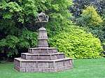 | |||
| 4, 5 & 6 Belmont Drive, (Belmont House), Including Boundary Wall, Gatepiers, Garden Ornaments And Coach House (1 Belmont Drive) | 55°56′50″N 3°15′07″W | Category A | 28032 | | |||
| Brunstane Road South, Brunstane House Steading, And Brunstane Farm Cottages (35-45 Odd Numbers) | 55°56′23″N 3°05′40″W | Category B | 28035 | | |||
| 15 And 17 Pilrig Street With Boundary Walls And Railings | 55°57′54″N 3°10′45″W | Category B | 27926 | | |||
| Inverleith Park Gatepiers Arboretum Road | 55°57′52″N 3°12′48″W | Category B | 27927 | | |||
| St Bernard's Bridge Dean Terrace | 55°57′23″N 3°12′38″W | Category B | 27948 |  | |||
| Swanston Road, Water House | 55°53′41″N 3°13′12″W | Category B | 27965 | | |||
| Colinton Road, Merchiston Castle School, Chalmers House | 55°54′44″N 3°15′17″W | Category B | 27983 | | |||
| Colinton Road, Merchiston Castle School South Lodge, Boundary Wall, Gatepiers And Gates | 55°54′36″N 3°15′02″W | Category C(S) | 27984 | | |||
| Colinton Road, Merchiston Castle School, Former Stables | 55°54′36″N 3°15′05″W | Category B | 27985 | | |||
| Calton Hill, Off Regent Road, Dugald Stewart's Monument | 55°57′16″N 3°11′04″W | Category A | 27835 |  | |||
| 23 And 25 Pilrig Street With Boundary Wall And Railings | 55°57′55″N 3°10′46″W | Category B | 27852 | | |||
| 4 Shore And 6 Tower Street, George Brown Engineering Works | 55°58′39″N 3°10′08″W | Category B | 27887 | | |||
| East Crosscauseway, Wellhead | 55°56′38″N 3°10′54″W | Category C(S) | 27898 | | |||
| 48 Timberbush | 55°58′34″N 3°10′05″W | Category B | 27904 | | |||
| 52-57 (Inclusive Nos) Timberbush | 55°58′35″N 3°10′08″W | Category B | 27908 | | |||
| Queen's Drive, St Margaret's Well | 55°57′03″N 3°10′06″W | Category B | 27909 | 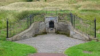 | |||
| 20-26 (Even Nos) Straiton Place 'Bellfield' | 55°57′11″N 3°06′31″W | Category C(S) | 27742 | | |||
| 314 And 316 Leith Walk | 55°57′54″N 3°10′37″W | Category C(S) | 27747 | | |||
| Ratho Village, 50 Main Street And Boundary Wall | 55°55′19″N 3°22′47″W | Category C(S) | 27765 | | |||
| 13 And 15 West Brighton Crescent | 55°57′05″N 3°07′11″W | Category B | 27766 | | |||
| 2-4 (Inclusive) Links Gardens And 35 Salamander Place With Boundary Walls And Railings | 55°58′20″N 3°09′45″W | Category B | 27767 | | |||
| 17 And 19 West Brighton Crescent | 55°57′06″N 3°07′11″W | Category B | 27770 | | |||
| Nicolson Street, Surgeon's Hall Including Screen Wall, Gates, Railings And Lamp Standards | 55°56′48″N 3°11′06″W | Category A | 27772 | 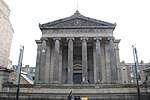 | |||
| Cambridge Street, Usher Hall, Including Sculpture And Standard Lamps | 55°56′51″N 3°12′18″W | Category A | 27780 |  | |||
| Ratho Village, 2 Wilkieston Road, West End Cottage And Boundary Walls | 55°55′14″N 3°23′09″W | Category C(S) | 27785 | | |||
| Union Canal, Mid Hermiston Bridge, Bridge No 11 | 55°55′10″N 3°19′18″W | Category B | 27802 | | |||
| 7 Windsor Place | 55°57′07″N 3°06′47″W | Category B | 27803 | | |||
| 9 Windsor Place | 55°57′06″N 3°06′47″W | Category B | 27807 | | |||
| 13, 15 And 17 Windsor Place | 55°57′05″N 3°06′47″W | Category B | 27811 | | |||
| Calton Hill, Off Regent Road, National Monument | 55°57′17″N 3°10′55″W | Category A | 27820 | 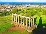 | |||
| 4 And 6 Nile Grove | 55°55′34″N 3°12′28″W | Category B | 27678 | | |||
| 8 Nile Grove | 55°55′34″N 3°12′26″W | Category B | 27683 | | |||
| 60 And 62 Leith Walk With Boundary Walls, Lamp Standards And Railings | 55°58′11″N 3°10′24″W | Category B | 27687 | | |||
| Ratho Village, 27 Baird Road, Bridge Inn | 55°55′24″N 3°22′44″W | Category C(S) | 27695 | | |||
| 5 Tipperlinn Road | 55°55′52″N 3°12′57″W | Category B | 27698 | | |||
| Ratho Village, 2 Baird Road And Wall | 55°55′21″N 3°22′40″W | Category B | 27705 | | |||
| 2A Rosefield Place, St James Parish Church (Church Of Scotland), Including Gatepiers And Boundary Walls | 55°57′07″N 3°07′01″W | Category B | 27706 | | |||
| Ratho Village, 4 And 6 Baird Road, Primrose Cottage And Summerhall Cottage With Walls And Gatepiers | 55°55′21″N 3°22′40″W | Category B | 27710 | | |||
| Ratho Village, 8 And 10 Baird Road, With Wall And Gatepiers | 55°55′21″N 3°22′40″W | Category B | 27715 | | |||
| 5-8 (Inclusive Nos) Sandford Gardens | 55°57′06″N 3°06′54″W | Category B | 27721 | | |||
| 1-11 (Odd Nos) Straiton Place, 51 Bath Street | 55°57′15″N 3°06′36″W | Category B | 27726 | | |||
| 280-284 (Even Nos) Leith Walk | 55°57′56″N 3°10′35″W | Category C(S) | 27727 | | |||
| Ratho Village, 4 Freelands Road (Former Manse) And Boundary Wall | 55°55′30″N 3°22′46″W | Category B | 27729 | | |||
| 14 Straiton Place | 55°57′13″N 3°06′33″W | Category B | 27730 | | |||
| 296 Leith Walk | 55°57′55″N 3°10′36″W | Category C(S) | 27731 | | |||
| 16 Straiton Place | 55°57′13″N 3°06′32″W | Category B | 27734 | | |||
| 108, 110, 112 Morningside Road And 1A Albert Terrace, Bank House, With Boundary Walls, Gatepiers And Railings | 55°55′53″N 3°12′38″W | Category B | 27602 | | |||
| Calton Hill, City Observatory, Including City Dome, Cox Dome, Tweedie Dome, Crawford Dome, Transit House, And Compound Walls | 55°57′18″N 3°11′01″W | Category A | 27603 | 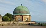 | |||
| Newliston House, The Garden House | 55°56′41″N 3°25′47″W | Category C(S) | 27604 | | |||
| 5 Newbattle Terrace With Gazebo And Boundary Wall | 55°55′53″N 3°12′27″W | Category B | 27635 | | |||
| Leith Docks, Tower Place, Harbour And Dock Offices | 55°58′43″N 3°10′04″W | Category C(S) | 27639 | | |||
| 7 Newbattle Terrace | 55°55′53″N 3°12′24″W | Category C(S) | 27640 | | |||
| 288-292 (Even Nos) Portobello High Street, 2 Bellfield Lane | 55°57′06″N 3°06′33″W | Category C(S) | 27506 | | |||
| 170-174 (Even Nos) Great Junction Street And 1-6 (Inclusive Nos) Taylor Gardens | 55°58′26″N 3°10′36″W | Category B | 27517 | | |||
| 348-350 Castlehill, The Hub Festival Centre | 55°56′56″N 3°11′43″W | Category A | 27542 |  | |||
| 17 And 19 Regent Street | 55°57′10″N 3°06′42″W | Category C(S) | 27544 | | |||
| 35-39 (Odd Nos) Regent Street (Marionville) Including Piers Boundary Walls And Railings | 55°57′12″N 3°06′40″W | Category C(S) | 27554 | | |||
| 41 Regent Street | 55°57′13″N 3°06′39″W | Category C(S) | 27559 | | |||
| 54 George Street And 53A Rose Street, Assembly Rooms And Music Hall | 55°57′10″N 3°11′55″W | Category A | 27567 | 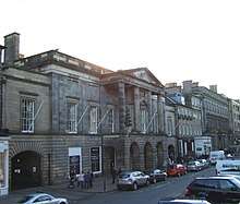 | |||
| 49 Regent Street | 55°57′14″N 3°06′37″W | Category C(S) | 27569 | | |||
| Ingliston House Stables And Gardener's House | 55°56′28″N 3°22′11″W | Category A | 27451 | | |||
| 123 Great Junction Street, St Thomas Junction Road Parish Church | 55°58′20″N 3°10′31″W | Category B | 27473 | | |||
| 14 Jordan Lane | 55°55′38″N 3°12′22″W | Category B | 27484 | | |||
| 204-208 (Even Nos) Great Junction Street Mecca State Social Club, Known As 205 | 55°58′30″N 3°10′40″W | Category B | 27487 | | |||
| Kirkliston Village, 25-27 (Odd Nos) High Street, Castle House | 55°57′14″N 3°24′07″W | Category B | 27499 | | |||
| 66 Polwarth Terrace With Boundary Wall And Gates | 55°55′55″N 3°13′32″W | Category B | 27363 | | |||
| 34 And 36 Marlborough Street | 55°57′12″N 3°06′35″W | Category B | 27364 | | |||
| 5B York Place, Former St George's Chapel (Episcopal), Including Railings And Lamps | 55°57′21″N 3°11′31″W | Category A | 27374 | | |||
| 87 Portland Street With Porch, Front Walls And Railings; Eh6 4Ay | 55°58′34″N 3°11′03″W | Category C(S) | 27375 | | |||
| Heriot-Watt University, Riccarton Estate, Former Walled Garden | 55°54′35″N 3°19′01″W | Category B | 27383 | | |||
| 108 And 110 Even Nos Polwarth Terrace | 55°55′47″N 3°13′39″W | Category C(S) | 27384 | | |||
| 2 And 4 Greenhill Park | 55°55′59″N 3°12′32″W | Category B | 27387 | | |||
| 170-174 (Even Nos) Constitution Street | 55°58′15″N 3°10′17″W | Category C(S) | 27392 | | |||
| St James The Less Church (Episcopal) Inverleith Row, Goldenacre | 55°58′14″N 3°12′32″W | Category B | 27394 | | |||
| 16 Greenhill Park With Boundary Wall, Gatepiers, Gateposts And Railings | 55°56′01″N 3°12′25″W | Category B | 27400 | | |||
| 45/1,2,3,4-47 (Odd Numbers) Spylaw Road And Boundary Wall And 5 Mid Gillsland Road | 55°55′53″N 3°13′17″W | Category B | 27404 | | |||
| 17 Duke Street And 3 Academy Street | 55°58′13″N 3°10′14″W | Category C(S) | 27406 | | |||
| 79-83 (Odd Nos) Duke Street | 55°58′11″N 3°10′07″W | Category B | 27419 | | |||
| 50 Spylaw Road | 55°55′55″N 3°13′16″W | Category C(S) | 27430 | | |||
| 221 Portobello High Street, Formerly Windsor Place Church | 55°57′05″N 3°06′44″W | Category C(S) | 27431 | | |||
| Palmerston Place, Cathedral Church Of St. Mary (Episcopal) | 55°56′54″N 3°13′00″W | Category A | 27441 |  | |||
| 9 Polwarth Terrace | 55°56′10″N 3°13′01″W | Category C(S) | 27321 | | |||
| 43 And 45 Marlborough Street (Raefield And Moss Cottage) | 55°57′13″N 3°06′36″W | Category C(S) | 27329 | | |||
| 1 And 3 Greenhill Gardens | 55°56′09″N 3°12′23″W | Category B | 27331 | | |||
| 14 Johnston Terrace, St Columba By The Castle Episcopal Church, With Retaining Wall And Terraced Garden | 55°56′54″N 3°11′43″W | Category B | 27332 |  | |||
| 3 (1-10) Portland Street With Front Wall And Railings; Eh6 4Sx | 55°58′41″N 3°10′52″W | Category B | 27333 | | |||
| 35 (1F, 2F & 3F) And 37 Portland Street With Front Walls, Steps And Railings; Eh6 4Bb | 55°58′38″N 3°10′56″W | Category B | 27340 | | |||
| Glasgow Road, Norton Mains, Steading And Garden Walls | 55°56′03″N 3°22′06″W | Category C(S) | 27229 | | |||
| 121-125 (Odd Nos) Constitution Street And Warehouse | 55°58′20″N 3°10′07″W | Category B | 27233 | | |||
| 283 Portobello High Street | 55°57′03″N 3°06′34″W | Category B | 27237 | | |||
| Queen Street Church (St Andrews Parish Church Halls) 42, 43 Queen Street | 55°57′15″N 3°12′07″W | Category B | 27242 | | |||
| 77 Falcon Avenue, St Peter's Church (Rc), Church Offices And Presbytery With Boundary Wall, Gatepiers And Railings | 55°55′50″N 3°12′22″W | Category A | 27257 | | |||
| 14 East Brighton Crescent | 55°57′02″N 3°07′02″W | Category B | 27263 | | |||
| 173 And 177-181 Constitution Street And 7, 7B, 9, 9A, 11 And 13 Duke Street, Former Palace Cinema | 55°58′14″N 3°10′15″W | Category C(S) | 27281 | | |||
| 18 Cluny Place And 18 Cluny Avenue | 55°55′34″N 3°12′05″W | Category B | 27156 | | |||
| 20 Merchiston Avenue And 1 Polwarth Terrace | 55°56′12″N 3°12′55″W | Category B | 27161 | | |||
| Newhaven Road, Bonnington Bridge | 55°58′18″N 3°11′15″W | Category B | 27168 | | |||
| 53-61 (Odd Nos) Colinton Road | 55°55′55″N 3°12′55″W | Category C(S) | 27175 | | |||
| 106 Newhaven Road With Front Wall; Eh6 4Br | 55°58′24″N 3°11′17″W | Category B | 27177 | | |||
| 59-65 (Odd Nos) Constitution Street With Railings | 55°58′27″N 3°10′02″W | Category B | 27183 | | |||
| 69 And 71 Constitution Street, Former St John's East Church (C Of S) | 55°58′26″N 3°10′02″W | Category C(S) | 27192 | | |||
| 1 And 2 East Brighton Crescent | 55°57′03″N 3°06′51″W | Category B | 27200 | | |||
| 89 Constitution Street | 55°58′24″N 3°10′04″W | Category B | 27201 | | |||
| 1-5 (Odd Nos) Madeira Street With Front Walls And Railings; Eh6 4Aj | 55°58′31″N 3°10′54″W | Category C(S) | 27101 | | |||
| 1-8 (Inclusive Nos) Vanburgh Place With Boundary Walls | 55°58′08″N 3°10′00″W | Category B | 27105 | | |||
| 2A And 3 Casselbank Street | 55°58′12″N 3°10′24″W | Category C(S) | 27117 | | |||
| Harrison Road Road Bridge | 55°56′02″N 3°13′28″W | Category C(S) | 27123 | | |||
| 20 And 22 Main Street, Including Grey Horse Inn | 55°53′02″N 3°20′21″W | Category C(S) | 27124 | | |||
| 51 Madeira Street, North Leith Parish Church With Burial Enclosure, Hall And Beadle's House, (1A Madeira Place) Gates, Railings And Boundary Wall; Eh6 4Ax | 55°58′33″N 3°10′59″W | Category A | 27134 | | |||
| 5 Pittville Street | 55°57′05″N 3°06′26″W | Category C(S) | 27136 | | |||
| 1-15 (Odd Nos) Cluny Place | 55°55′35″N 3°12′03″W | Category B | 27141 | | |||
| Glasgow Road, Gogar Mount Stables And Dovecot | 55°56′05″N 3°21′03″W | Category B | 27143 | | |||
| 7 Pittville Street | 55°57′05″N 3°06′26″W | Category C(S) | 27144 | | |||
| 26-30 (Even Nos) Madeira Street (Formerly Kyle Place) With Front Wall, Railings And Gates; Eh6 4Al | 55°58′32″N 3°10′54″W | Category C(S) | 27149 | | |||
| Glasgow Road, Gogar Mount House, Walled Garden With Wellhead | 55°56′04″N 3°21′00″W | Category C(S) | 27150 | | |||
| 1 And 3 Joppa Road, Including Boundary Walls | 55°56′57″N 3°06′07″W | Category B | 27022 | |
Key
The scheme for classifying buildings in Scotland is:
- Category A: "buildings of national or international importance, either architectural or historic; or fine, little-altered examples of some particular period, style or building type."[1]
- Category B: "buildings of regional or more than local importance; or major examples of some particular period, style or building type, which may have been altered."[1]
- Category C: "buildings of local importance; lesser examples of any period, style, or building type, as originally constructed or moderately altered; and simple traditional buildings which group well with other listed buildings."[1]
In March 2016 there were 47,288 listed buildings in Scotland. Of these, 8% were Category A, and 50% were Category B, with the remaining 42% being Category C.[2]
Notes
- Sometimes known as OSGB36, the grid reference (where provided) is based on the British national grid reference system used by the Ordnance Survey.
• "Guide to National Grid". Ordnance Survey. Retrieved 12 December 2007.
• "Get-a-map". Ordnance Survey. Retrieved 17 December 2007. - Historic Environment Scotland assign a unique alphanumeric identifier to each designated site in Scotland, for listed buildings this always begins with "LB", for example "LB12345".
References
- All entries, addresses and coordinates are based on data from Historic Scotland. This data falls under the Open Government Licence
- "What is Listing?". Historic Environment Scotland. Retrieved 29 May 2018.
- Scotland's Historic Environment Audit 2016 (PDF). Historic Environment Scotland and the Built Environment Forum Scotland. pp. 15–16. Retrieved 29 May 2018.
This article is issued from Wikipedia. The text is licensed under Creative Commons - Attribution - Sharealike. Additional terms may apply for the media files.