List of hillside letters in Utah

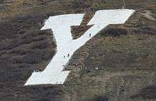
This is a list of hillside letters (also known as mountain monograms) in the U.S. state of Utah.[1][2][3] Monograms in Utah include two of the oldest, at Brigham Young University (1906) and the University of Utah (1907). These symbols are so much a part of the culture that locals typically refer to the universities themselves as "The Y" and "The U," respectively. Across the state, there are at least 83 hillside letters, acronyms, and messages.

MonogramTownCountyConstruction YearDescriptionLocation
AAltonKane37.4355°N 112.4960°W / 37.4355; -112.4960 (Alton)
BRTremontonBox ElderBear River High School41.7593°N 112.2021°W / 41.7593; -112.2021 (Bear River High School)
BBeaverBeaverBeaver High School38.2657°N 112.5825°W / 38.2657; -112.5825 (Beaver)
BLOgdenWeberBen Lomond High School41.2506°N 111.9308°W / 41.2506; -111.9308 (Ben Lomond High School)
BSouth JordanSalt LakeBingham High School40.5686°N 112.1165°W / 40.5686; -112.1165 (Bingham High School)
BBountifulDavisBountiful High School40.8975°N 111.8463°W / 40.8975; -111.8463 (Bountiful)
BBrigham CityBox ElderBox Elder High School41.52°N 111.9906°W / 41.52; -111.9906 (Brigham City)
YProvoUtah1906Brigham Young University40.2483°N 111.6206°W / 40.2483; -111.6206 (Brigham Young University)
BCottonwood HeightsSalt LakeBrighton High School40.6096°N 111.7859°W / 40.6096; -111.7859 (Brighton High School)
BVTropicGarfieldBryce Valley High School37.6245°N 112.0629°W / 37.6245; -112.0629 (Bryce Valley High School)
CVCedar CityIronCanyon View High School37.708299°N 113.055591°W / 37.708299; -113.055591 (Canyon View CV)
CPriceCarbonCarbon High School39.6086°N 110.8125°W / 39.6086; -110.8125 (Carbon High School)
CCedar CityIron Cedar High School37.6426°N 113.0351°W / 37.6426; -113.0351 (Cedar City)
CEast CarbonCarbonFor the former town of Columbia39.5142°N 110.3854°W / 39.5142; -110.3854 (Columbia)
CMagnaSalt LakeCyprus High School40.708°N 112.1322°W / 40.708; -112.1322 (Cyprus High School)
DIXIESt. GeorgeWashingtonDixie High School37.1159°N 113.5792°W / 37.1159; -113.5792 (Dixie High School)
DSt. GeorgeWashingtonDixie State University37.1081°N 113.5977°W / 37.1081; -113.5977 (Dixie State University)
DDuchesneDuchesne40.1658°N 110.4094°W / 40.1658; -110.4094 (Duchesne)
ECEast CarbonCarbonEast Carbon High School39.559221°N 110.394149°W / 39.559221; -110.394149 (East Carbon High School)
EElsinoreSevier38.6849°N 112.1607°W / 38.6849; -112.1607 (Elsinore)
EEnterpriseWashington37.5525°N 113.7484°W / 37.5525; -113.7484 (Enterprise)
EEscalanteGarfield37.7884°N 111.582°W / 37.7884; -111.582 (Escalante)
FREMONT COUNTRYBeaver CountyBeaverRough painted rocks mostly hidden among the sagebrush on a shallow south-facing hill adjacent to I-1538.1123°N 112.6479°W / 38.1123; -112.6479 (BEAVER COUNTY)
FGFountain GreenSanpete39.6357°N 111.6326°W / 39.6357; -111.6326 (Fountain Green)
GGlenwoodSevier38.7738°N 111.9824°W / 38.7738; -111.9824 (Glenwood)
GMoabGrandGrand County High School38.5898°N 109.5509°W / 38.5898; -109.5509 (GCHS Block G)
GGreen RiverEmery38.9853°N 110.1682°W / 38.9853; -110.1682 (Green River)
GGunnisonSanpete39.1557°N 111.8357°W / 39.1557; -111.8357 (Gunnison)
GPleasant GroveUtah1920 Short for "Grovarian", or "Grove" - the original mascot and old school nickname, respectively. [4]40.3735°N 111.7013°W / 40.3735; -111.7013 (Pleasant Grove)
GREEN VALLEYSt. GeorgeWashingtonneighborhood37.096°N 113.6228°W / 37.096; -113.6228 (neighborhood)
HHeneferSummit41.0094°N 111.5028°W / 41.0094; -111.5028 (Henefer)
HSalt Lake CitySalt LakeHighland High School40.7306°N 111.8114°W / 40.7306; -111.8114 (Highland High School)
HOLE N' THE ROCKSan JuanHole N' the Rock (Moab)38.3911°N 109.4544°W / 38.3911; -109.4544 (Hole N' the Rock)
HHurricaneWashington37.1742°N 113.2815°W / 37.1742; -113.2815 (Hurricane)
IBrigham CityBox ElderIntermountain Indian School (closed)41.4829°N 111.9993°W / 41.4829; -111.9993 (Intermountain Indian School (closed))
JNephiJuabJuab High School39.7415°N 111.8182°W / 39.7415; -111.8182 (Juab High School)
KKanabKane37.0482°N 112.5175°W / 37.0482; -112.5175 (Kanab)
KKingstonPiute38.2054°N 112.1819°W / 38.2054; -112.1819 (Kingston)
LLapointUintah40.410375°N 109.788275°W / 40.410375; -109.788275 (Lapoint)
LLa VerkinWashington37.2008°N 113.2632°W / 37.2008; -113.2632 (La Verkin)
LLeedsWashington37.2424°N 113.361°W / 37.2424; -113.361 (Leeds)
MMammothJuab39.9317°N 112.1052°W / 39.9317; -112.1052 (Mammoth)
MManilaDaggett40.9937°N 109.7294°W / 40.9937; -109.7294 (Manila)
MMantiSanpete39.2624°N 111.6101°W / 39.2624; -111.6101 (Manti)
MMarysvalePiute38.4566°N 112.2143°W / 38.4566; -112.2143 (Marysvale)
M (no longer exists)MilfordBeaver38.3986°N 113.0098°W / 38.3986; -113.0098 (Milford) (uncertain location)
MFillmoreMillardMillard High School38.9848°N 112.272°W / 38.9848; -112.272 (Millard High School)
MMorganMorgan41.0283°N 111.659°W / 41.0283; -111.659 (Morgan)
MMoroniSanpete39.5434°N 111.5782°W / 39.5434; -111.5782 (Moroni)
MMountain Home Duchesne40.383233°N 110.391111°W / 40.383233; -110.391111 (Mountain Home)
MCHyrumCacheMountain Crest High School41.6178°N 111.801°W / 41.6178; -111.801 (Mountain Crest High School)
NCRichmondCacheNorth Cache Junior High School41.9243°N 111.7867°W / 41.9243; -111.7867 (North Cache Junior High School)
NRLaketownRichNorth Rich Junior High School41.8255°N 111.3127°W / 41.8255; -111.3127 (North Rich High School)
NSSalinaSevierNorth Sevier High School38.9557°N 111.8219°W / 38.9557; -111.8219 (North Sevier High School)
NSCoalvilleSummitNorth Summit High School40.9083°N 111.3855°W / 40.9083; -111.3855 (North Summit High School)
PCPark CitySummitPark City High School40.6738°N 111.487°W / 40.6738; -111.487 (Park City)
PParowanIron37.8312°N 112.821°W / 37.8312; -112.821 (Parowan)
PPaysonUtahPayson High School40.0249°N 111.7163°W / 40.0249; -111.7163 (Payson High School)
PPetersonMorgan41.1012°N 111.7678°W / 41.1012; -111.7678 (Peterson)
PJunctionPiutePiute High School38.2427°N 112.245°W / 38.2427; -112.245 (Piute High School)
RRichfieldSevier38.7614°N 112.1119°W / 38.7614; -112.1119 (Richfield)
RRooseveltDuchesne40.311773°N 109.999249°W / 40.311773; -109.999249 (Roosevelt)
SJBlandingSan JuanSan Juan High School37.6414°N 109.4835°W / 37.6414; -109.4835 (San Juan High School)
SShivwitsWashington37.1836°N 113.7534°W / 37.1836; -113.7534 (Shivwits)
SHolladaySalt LakeSkyline High School (Utah)40.693°N 111.7842°W / 40.693; -111.7842 (Skyline High School)
SVSmithfieldCacheSky View High School41.821°N 111.7992°W / 41.821; -111.7992 (Sky View High School)
SEphraimSanpeteSnow College39.3441°N 111.5391°W / 39.3441; -111.5391 (Snow College)
SSMonroeSevierSouth Sevier High School38.6316°N 112.1007°W / 38.6316; -112.1007 (South Sevier High School)
SSKamasSummitSouth Summit High School40.6475°N 111.2689°W / 40.6475; -111.2689 (South Summit High School)
SSterlingSanpete39.1945°N 111.6993°W / 39.1945; -111.6993 (Sterling)
TTabionaDuchesne40.354956°N 110.698427°W / 40.354956; -110.698427 (Tabiona)
TEurekaJuabTintic High School39.9509°N 112.1071°W / 39.9509; -112.1071 (Tintic High School)
TTooeleTooeleTooele High School40.5249°N 112.2482°W / 40.5249; -112.2482 (Tooele)
TTropicGarfield37.621°N 112.0819°W / 37.621; -112.0819 (Tropic)
TRIDELLTridellUintah40.454203°N 109.845327°W / 40.454203; -109.845327 (Tridell)
UUintahWeber41.1429°N 111.8995°W / 41.1429; -111.8995 (Uintah)
UVernalUintahUintah High School40.4386°N 109.6057°W / 40.4386; -109.6057 (Uintah High School)
USalt Lake CitySalt Lake1907University of Utah40.7794°N 111.8399°W / 40.7794; -111.8399 (University of Utah)
VOrdervilleKaneValley High School37.2813°N 112.6371°W / 37.2813; -112.6371 (Valley High School)
VVeniceSevier38.8029°N 111.9724°W / 38.8029; -111.9724 (Venice)
VCentervilleDavisViewmont High School40.9094°N 111.8557°W / 40.9094; -111.8557 (Viewmont High School)
WBicknellWayneWayne High School38.347981°N 111.533718°W / 38.347981; -111.533718 (Wayne W)
WWendoverTooele40.7454°N 114.0297°W / 40.7454; -114.0297 (Wendover)
WMontezuma CreekSan JuanWhitehorse High School37.2713°N 109.3059°W / 37.2713; -109.3059 (Whitehorse High School)
The Block U in Salt Lake City, trademark of the University of Utah

References

  1. Corning, Evelyn (2007). Hillside Letters A to Z : A Guide to Hometown Landmarks. Missoula, Montana: Mountain Press Publishing Company.
  2. Rocha, Guy (June 2004). "Hillside Letters: In Plain Sight But Not Intended for Planes". Sierra Sage. Archived from the original on 2011-07-22. Retrieved 2011-08-09.
  3. Parsons, James J. (1988). "Hillside Letters in the Western United States". Landscape. Sante Fe, N.M. 30 (1): 15–23. Retrieved 9 Aug 2011.
  4. Franscell, Ashley (20 May 2014). "G: The Pleasant Grove G". Daily Herald. Provo, UT. Retrieved 11 May 2018.
This article is issued from Wikipedia. The text is licensed under Creative Commons - Attribution - Sharealike. Additional terms may apply for the media files.