List of hillside letters in Montana

This is a list of hillside letters (also known as mountain monograms) in the U.S. state of Montana.[1][2][3] There are at least 80 hillside letters, acronyms, and messages in the state, possibly as many as 88. While western Montana provides plenty of mountains to support these monograms, many towns in the eastern prairie have also placed them on whatever hill they can find.

MonogramTownDescriptionLocation
FishLivingston"Trout capital of the world"45.6708°N 110.5641°W / 45.6708; -110.5641 ('Trout capital of the world')
AAbsarokee45.5172°N 109.4376°W / 45.5172; -109.4376 (Absarokee)
AAnaconda46.1174°N 112.9706°W / 46.1174; -112.9706 (Anaconda)
AArlee47.156506°N 114.094879°W / 47.156506; -114.094879 (Arlee)
B (uncertain existence)Baker46.3651°N 104.2741°W / 46.3651; -104.2741 (Baker) (uncertain location)
BDillon Beaverhead County High School45.2389°N 112.6676°W / 45.2389; -112.6676 (Barrett High School)
BBozeman45.7241°N 110.9825°W / 45.7241; -110.9825 (Bozeman)
BBridger45.295342°N 108.928286°W / 45.295342; -108.928286 (Bridger)
BBroadus45.4479°N 105.4107°W / 45.4479; -105.4107 (Broadus)
C (poor maintenance)HelenaCarroll College46.5704°N 112.0299°W / 46.5704; -112.0299 (Carroll College)
CEkalakaCarter County High School45.8973°N 104.5453°W / 45.8973; -104.5453 (Carter Co. High School)
CCascade47.2815°N 111.7103°W / 47.2815; -111.7103 (Cascade)
CAnacondaAnaconda High School46.114°N 112.9512°W / 46.114; -112.9512 (Central High School)
CCharlo47.4502°N 114.256°W / 47.4502; -114.256 (Charlo)
CCircle47.4255°N 105.5889°W / 47.4255; -105.5889 (Circle)
C (uncertain existence)Colstrip45.885°N 106.6331°W / 45.885; -106.6331 (Colstrip) (uncertain location)
CColumbus45.6521°N 109.2505°W / 45.6521; -109.2505 (Columbus)
CCorvallis46.3359°N 114.0261°W / 46.3359; -114.0261 (Corvallis)
CMRGreat FallsC.M. Russell High School47.492892°N 111.348718°W / 47.492892; -111.348718 (Great Falls)
DDarbyDarby High School46.0248°N 114.1649°W / 46.0248; -114.1649 (Darby)
D (uncertain existence)GlendiveDawson County High School47.1123°N 104.7066°W / 47.1123; -104.7066 (Dawson High School) (uncertain location)
DDenton47.3124°N 109.9366°W / 47.3124; -109.9366 (Denton)
DDrummond46.6701°N 113.1407°W / 46.6701; -113.1407 (Drummond)
EEnnis45.3505°N 111.7478°W / 45.3505; -111.7478 (Ennis)
FLewistownFergus High School47.0541°N 109.4230°W / 47.0541; -109.4230 (Fergus High School)
FKalispellFlathead High School48.1793°N 114.3816°W / 48.1793; -114.3816 (Flathead High School)
FForsyth46.2613°N 106.674°W / 46.2613; -106.674 (Forsyth)
F (no longer exists)Frazer48.0601°N 106.0398°W / 48.0601; -106.0398 (Frazer) (uncertain location)
FFrenchtown47.0218°N 114.2212°W / 47.0218; -114.2212 (Frenchtown)
F (uncertain existence)Fromberg45.3886°N 108.9209°W / 45.3886; -108.9209 (Fromberg) (uncertain location)
FBFt. Benton47.8101°N 110.6626°W / 47.8101; -110.6626 (Ft. Benton)
GGardiner45.038°N 110.7062°W / 45.038; -110.7062 (Gardiner)
GGeraldine47.6057°N 110.287°W / 47.6057; -110.287 (Geraldine)
GGeyser47.2861°N 110.5089°W / 47.2861; -110.5089 (Geyser)
GGlasgow48.2118°N 106.6395°W / 48.2118; -106.6395 (Glasgow)
GPhilipsburgGranite High School46.3306°N 113.283°W / 46.3306; -113.283 (Granite High School)
GRGrass Range47.027°N 108.8087°W / 47.027; -108.8087 (Grass Range)
GFGreat FallsGreat Falls High School47.5218°N 111.3353°W / 47.5218; -111.3353 (Great Falls)
HHamilton46.2342°N 114.2315°W / 46.2342; -114.2315 (Hamilton)
HHarlowton46.4445°N 109.8154°W / 46.4445; -109.8154 (Harlowton)
HHavreHavre High School48.5232°N 109.6386°W / 48.5232; -109.6386 (Saddle Butte)
HHavreHavre High School48.546896°N 109.687308°W / 48.546896; -109.687308 (Blue Pony stadium)
HHelena46.590876°N 112.059953°W / 46.590876; -112.059953 (Helena)
H (no longer exists)MissoulaHellgate High School46.8624°N 113.9966°W / 46.8624; -113.9966 (Hellgate High School) (uncertain location)
HHighwood47.5801°N 110.7935°W / 47.5801; -110.7935 (Highwood)
HHinsdale48.3778°N 107.0964°W / 48.3778; -107.0964 (Hinsdale)
HHot Springs47.6263°N 114.651°W / 47.6263; -114.651 (Hot Springs)
HHysham46.2624°N 107.2249°W / 46.2624; -107.2249 (Hysham)
JJackson45.3805°N 113.3982°W / 45.3805; -113.3982 (Jackson) (uncertain location)
JBoulderJefferson High School46.2448°N 112.1486°W / 46.2448; -112.1486 (Jefferson High School)
JJoliet45.4808°N 108.9598°W / 45.4808; -108.9598 (Joliet)
JJordan47.3151°N 106.8984°W / 47.3151; -106.8984 (Jordan)
KKlein46.4006°N 108.5512°W / 46.4006; -108.5512 (Klein)
KG (uncertain existence)GildfordKremlin-Gildford High School (closed)48.5698°N 110.3°W / 48.5698; -110.3 (Kremlin-Gildford High School) (uncertain location)
LLavina46.3114°N 108.9335°W / 46.3114; -108.9335 (Lavina)
L (no longer exists)Lewistown45.67°N 110.5621°W / 45.67; -110.5621 (Lewistown) (uncertain location)
LLibby48.3943°N 115.5087°W / 48.3943; -115.5087 (Libby)
LLima44.6185°N 112.5784°W / 44.6185; -112.5784 (Lima)
LEurekaLincoln County High School48.8842°N 115.0561°W / 48.8842; -115.0561 (Lincoln High School)
LMissoulaLoyola High School46.8728°N 113.9685°W / 46.8728; -113.9685 (Loyola High School)
M (uncertain existence)Malta48.3549°N 107.8701°W / 48.3549; -107.8701 (Malta) (uncertain location)
MSt. IgnatiusMission High School47.3007°N 114.1066°W / 47.3007; -114.1066 (Mission High School)
MBozemanMontana State University45.7144°N 110.9735°W / 45.7144; -110.9735 (Montana State University)
MButteMontana Tech, built 191046.0191°N 112.5587°W / 46.0191; -112.5587 (Montana Tech Miners)
MMissoulaUniversity of Montana, built 190946.8594°N 113.9757°W / 46.8594; -113.9757 (University of Montana)
MDillonUniversity of Montana Western45.2209°N 112.6671°W / 45.2209; -112.6671 (University of Montana Western)
NNashua48.1381675°N 106.3566111°W / 48.1381675; -106.3566111 (Nashua)
NHavreMontana State University Northern48.546977°N 109.686583°W / 48.546977; -109.686583 (Blue Pony stadium)
PLivingstonPark High School45.6714°N 110.5624°W / 45.6714; -110.5624 (Park High School)
PPlains47.4619°N 114.872°W / 47.4619; -114.872 (Plains)
PPolson47.6798°N 114.1471°W / 47.6798; -114.1471 (Polson)
PDeer LodgePowell County High School46.4222°N 112.7599°W / 46.4222; -112.7599 (Powell High School)
RLRed Lodge45.1766°N 109.2425°W / 45.1766; -109.2425 (Red Lodge)
RRedstone48.8237°N 104.9505°W / 48.8237; -104.9505 (Redstone)
RReed Point45.7026°N 109.5424°W / 45.7026; -109.5424 (Reed Point)
RRoberts45.3764°N 109.1864°W / 45.3764; -109.1864 (Roberts)
R (no longer exists)BillingsRocky Mountain College45.8023°N 108.5547°W / 45.8023; -108.5547 (Rocky Mountain College) (uncertain location)
RRosebud46.273°N 106.4372°W / 46.273; -106.4372 (Rosebud)
R (uncertain existence)Roundup46.4381°N 108.5376°W / 46.4381; -108.5376 (Roundup) (uncertain location)
RRoy47.3227°N 108.9527°W / 47.3227; -108.9527 (Roy)
RRyegate46.3023°N 109.2568°W / 46.3023; -109.2568 (Ryegate)
S (no longer exists)MissoulaSentinel High School46.847°N 114.0099°W / 46.847; -114.0099 (Sentinel High School) '
SShelby48.5195°N 111.8671°W / 48.5195; -111.8671 (Shelby)
SSheridanSheridan K-12 Schools45.4514°N 112.1251°W / 45.4514; -112.1251 (Sheridan)
R (uncertain existence)Saint Regis47.3064°N 115.1053°W / 47.3064; -115.1053 (St. Regis) (uncertain location)
SStanford47.1655°N 110.2724°W / 47.1655; -110.2724 (Stanford)
SSuperior47.1955°N 114.8791°W / 47.1955; -114.8791 (Superior)
TTerry46.81058°N 105.3153°W / 46.81058; -105.3153 (Terry)
TThree Forks45.8864°N 111.6501°W / 45.8864; -111.6501 (Three Forks)
TBTwin Bridges45.5653°N 112.3127°W / 45.5653; -112.3127 (Twin Bridges)
UUlm47.4387°N 111.4999°W / 47.4387; -111.4999 (Ulm)
VVictor46.4396°N 114.1992°W / 46.4396; -114.1992 (Victor)
WWhitehall45.910345°N 112.037352°W / 45.910345; -112.037352 (Whitehall)
W (uncertain existence)Wibaux46.9878°N 104.1877°W / 46.9878; -104.1877 (Wibaux) (uncertain location)
WWindham47.084°N 110.139°W / 47.084; -110.139 (Windham)
WWinifred47.5651°N 109.3685°W / 47.5651; -109.3685 (Winifred)
WWinnett46.992°N 108.3458°W / 46.992; -108.3458 (Winnett)
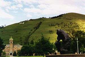
The M on Mt. Sentinel overlooks the University of Montana in Missoula
The M of Montana Tech, overlooking Butte

Sources

  1. Corning, Evelyn (2007). Hillside Letters A to Z: A Guide to Hometown Landmarks. Missoula, Montana: Mountain Press Publishing Company. ISBN 978-0-87842-533-4. OCLC 79256698. OL 8556565W.
  2. Parsons, James J. (1988). "Hillside Letters in the Western United States". Landscape. Sante Fe, New Mexico. 30 (1): 15–23. Archived from the original on 2015-08-16. Retrieved 2015-08-16.
  3. Rocha, Guy (June 2004). "Hillside Letters: In Plain Sight But Not Intended for Planes". Sierra Sage. Archived from the original on 2015-08-17.
This article is issued from Wikipedia. The text is licensed under Creative Commons - Attribution - Sharealike. Additional terms may apply for the media files.