List of New York State Historic Markers in Delaware County, New York
This is an incomplete list of New York State Historic Markers in Delaware County, New York.[1] A fuller list is available from the Association of Public Historians of New York State.[2]
Listings county-wide
| # | Marker Name | Image | Designator | Location | City or Town | Coords | Marker Text |
|---|---|---|---|---|---|---|---|
| 1 | DOWNSVILLE COVERED BRIDGE (north end) | 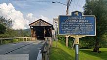 Historic marker of Downsville Bridge, north side |
Downsville Women's Club (no date but must be 1998 or later) | North side of Downsville Bridge | Downsville | 42°04′35.16″N 74°59′27.81″W | DOWNSVILLE COVERED BRIDGE
BUILT IN 1854 BY ROBERT MURRAY |
| 2 | DOWNSVILLE COVERED BRIDGE (south end) |  Historic marker of Downsville Bridge, south side |
Downsville Women's Club (no date but must be 1999 or later) | South side of Downsville Bridge | Downsville | 42°04′33.74″N 74°59′25.55″W | DOWNSVILLE COVERED BRIDGE
HAS BEEN PLACED ON THE NATIONAL |
| 3 | HOMESTEAD OF DR PLATT TOWNSEND | 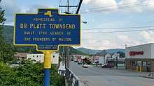 Historic marker for Dr Platt Townsend |
State Ed Dept, 1938 | Intersection of Delaware Street and West Brook | Walton | 42°10′09.41″N 75°08′02.25″W | HOMESTEAD OF DR PLATT TOWNSEND
BUILT 1796 LEADER OF |
| 4 | TURNPIKE | 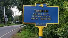 Historic marker for Turnpike |
State Ed Dept, 1949 | Intersection of Delaware St, Prospect St. and Highway 206 | Walton | 42°10′14.55″N 75°08′19.71″W | TURNPIKE
HISTORIC ROUTE FROM KINGSTON TO JERICHO (BAINBRIDGE) |
| 5 | WALTON COVERED BRIDGE | 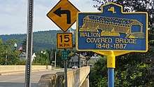 Walton Covered Bridge |
(no date or agency) | North and South Side of the Bridge | Walton | 42°10′01.78″N 75°07′48.57″W | WALTON COVERED BRIDGE
1846-1887 |
| 6 | MIDDLETOWN SETTLEMENT | 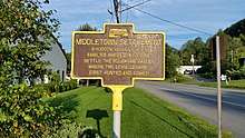 Middletown founding sign |
(no date or agency) | NY State 28, east of the hospital | Walton | 42°08′48.15″N 74°38′17.19″W | MIDDLETOWN SETTLEMENT
3 HUDSON VALLEY DUTCH |
| 7 | OLD STONE SCHOOLHOUSE | 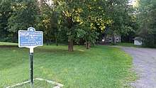 Old Stone Schoolhouse sign, by roadside |
(no date or agency) | NY State 28, at Huckleberry Brook | Margaretville | 42°07′19.25″N 74°40′28.53″W | OLD STONE SCHOOLHOUSE
DISTRICT #10, DUNRAVEN, NY |
| 8 | STONE SCHOOL HOUSE | 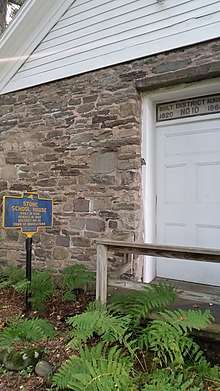 Old Stone School House sign, by school |
State Ed Dept, 1932 | NY State 28, at Huckleberry Brook | Margaretville | 42°07′20.15″N 74°40′31.22″W | STONE SCHOOL HOUSE
BUILT IN 1820 |
See also
References
- "New York State Historic Markers". New York State Historic Markers. New York Museum. 2009-05-05.
- "Historical Markers". Association of Public Historians of NYS. Retrieved 24 August 2017.