List of Indiana state historical markers in Randolph County
This is a list of the Indiana state historical markers in Randolph County.

Location of Randolph County in Indiana
This is intended to be a complete list of the official state historical markers placed in Randolph County, Indiana, United States by the Indiana Historical Bureau. The locations of the historical markers and their latitude and longitude coordinates are included below when available, along with their names, years of placement, and topics as recorded by the Historical Bureau. There are 2 historical markers located in Randolph County.[1]
Historical markers
| Marker title | Image | Year placed | Location | Topics |
|---|---|---|---|---|
| Farmland Downtown Historic District[2] | 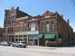 |
2005 | 106 N. Main Street in Farmland 40°11′17″N 85°7′39″W |
Historic District, Neighborhoods, and Towns, Buildings and Architecture, Agriculture, Transportation |
| Lee L. Driver[3] | 2009 | Driver Middle School, 130 S. County Road 100E near Winchester 40°10′19″N 84°57′27″W |
Education and libraries | |
| Union Literary Institute |  |
2016 | 8605 East 600 South, Union City 40°04′38″N 84°48′59″W | Racially integrated school |
See also
References
- "Indiana Historical Markers by County". State of Indiana. Retrieved 2012-03-15.
- Farmland Downtown Historic District, Indiana Historical Bureau, n.d. Accessed 2012-03-14.
- Lee L. Driver, Indiana Historical Bureau, n.d. Accessed 2012-03-14.
External links
Municipalities and communities of Randolph County, Indiana, United States | ||
|---|---|---|
| Cities | Map of Indiana highlighting Randolph County | |
| Towns | ||
| Townships | ||
| Unincorporated communities | ||
| Former communities |
| |
This article is issued from Wikipedia. The text is licensed under Creative Commons - Attribution - Sharealike. Additional terms may apply for the media files.