List of Indiana state historical markers in Huntington County
This is a list of the Indiana state historical markers in Huntington County.

Location of Huntington County in Indiana
This is intended to be a complete list of the official state historical markers placed in Huntington County, Indiana, United States by the Indiana Historical Bureau. The locations of the historical markers and their latitude and longitude coordinates are included below when available, along with their names, years of placement, and topics as recorded by the Historical Bureau. There are 10 historical markers located in Huntington County.[1]
Historical markers
| Marker title | Image | Year placed | Location | Topics |
|---|---|---|---|---|
| Pioneer Medical Doctors/Chase S. Osborn[2] |  |
1949 | Southeastern corner of the junction of State Roads 105 and 124, west of Mount Etna 40°44′26″N 85°37′15″W |
Science, Medicine, and Inventions, Women |
| Home of Chief Richardville[3] | 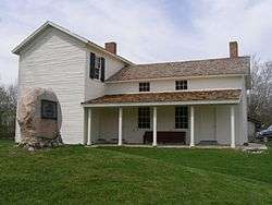 |
1966 | Forks of the Wabash Historic Park at the southwestern corner of the junction of U.S. Route 24 and State Road 9 near Huntington 40°52′39″N 85°31′58″W |
American Indian/Native American |
| Forks of Wabash[4] | 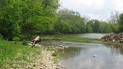 |
1972 | Junction of Business U.S. Route 24 and W. Park Drive east of the State Road 9 junction near Huntington 40°52′38.2″N 85°31′50″W |
American Indian/Native American, Transportation, Business, Industry, and Labor |
| Canal Landing on Washington Street/ Jefferson Park Mall: Indiana's First Tax-Free Mall[5] |  |
1973 | Junction of Washington and N. Jefferson Streets in Huntington 40°52′58″N 85°29′44″W |
Transportation, Business, Industry, and Labor |
| Drover Town[6] | 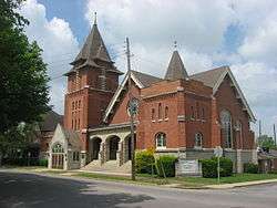 |
1979 | One block north of the junction of Etna Avenue and Henry Street on the property of St. Peter's First United Church of Christ in Huntington 40°52′40″N 85°29′38″W |
Historic District, Neighborhoods, and Towns, Immigration and Ethnic Groups |
| The "Lime City"[7] |  |
1979 | Junction of W. Park Drive and Diamond Street at Sunken Gardens Park in Huntington 40°52′41.7″N 85°30′24″W |
Business, Industry, and Labor |
| Huntington's Buildings over the River: Controversy to Controversy/Huntington's Ford and First Bridge[8] |  |
1979 | Jefferson Street bridge over the Little River in Huntington 40°52′45.4″N 85°29′35.6″W |
Buildings and Architecture, Business, Industry, and Labor, Transportation |
| Wabash & Erie Canal Lock 4[9] | 1997 | 339 E. First Street at U.S. Route 24 in Roanoke 40°57′42.3″N 85°22′16″W |
Transportation, Business, Industry, and Labor | |
| Kiilhsoohkwa (Kilsoquah)[10] | 2005 | Glenwood Cemetery in the 1000 block of N. Main Street in Roanoke 40°58′16″N 85°22′19″W |
American Indian/Native American, Women, Government Institutions, Early Settlement and Exploration | |
| Warren's Carnegie Library[11] |  |
2007 | 123 E. Third St. in Warren 40°41′0.6″N 85°25′32″W |
Carnegie Libraries, Buildings and Architecture |
See also
References
- "Indiana Historical Markers by County". State of Indiana. Retrieved 2012-03-15.
- Pioneer Medical Doctors/Chase S. Osborn, Indiana Historical Bureau, n.d. Accessed 2012-03-14.
- Home of Chief Richardville, Indiana Historical Bureau, n.d. Accessed 2012-03-14.
- Forks of Wabash, Indiana Historical Bureau, n.d. Accessed 2012-03-14.
- Canal Landing on Washington Street/ Jefferson Park Mall: Indiana's First Tax-Free Mall, Indiana Historical Bureau, n.d. Accessed 2012-03-14.
- Drover Town, Indiana Historical Bureau, n.d. Accessed 2012-03-14.
- The "Lime City", Indiana Historical Bureau, n.d. Accessed 2012-03-14.
- Huntington's Buildings over the River: Controversy to Controversy/Huntington's Ford and First Bridge, Indiana Historical Bureau, n.d. Accessed 2012-03-14.
- Wabash & Erie Canal Lock 4, Indiana Historical Bureau, n.d. Accessed 2012-03-14.
- Kiilhsoohkwa (Kilsoquah), Indiana Historical Bureau, n.d. Accessed 2012-03-14.
- Warren's Carnegie Library, Indiana Historical Bureau, n.d. Accessed 2012-03-14.
External links
Municipalities and communities of Huntington County, Indiana, United States | ||
|---|---|---|
| City | Map of Indiana highlighting Huntington County | |
| Towns | ||
| Townships | ||
| Unincorporated communities | ||
| Footnotes | ‡This populated place also has portions in an adjacent county or counties | |
This article is issued from Wikipedia. The text is licensed under Creative Commons - Attribution - Sharealike. Additional terms may apply for the media files.