List of Cultural Properties of Japan struck from the register
This list is of former Cultural Properties of Japan that have been struck from the register as a result of heavy damage or total destruction during the twentieth and early twenty-first centuries, as identified and catalogued by the Agency for Cultural Affairs.[1][2]
Structures
101 properties
Castles
17 properties
| Property | Date | Municipality | Date of designation | Date of loss | Comments | Image | Coordinates |
|---|---|---|---|---|---|---|---|
| Fukuyama (Matsumae) Castle Tenshu, East Wall of Main Gate 福山城 (松前城) 天守、本丸御門東塀 Fukuyama-jō (Mastumae-jō) tenshu, honmaru gomon higashi-bei | Edo period | Matsumae | 8 May 1941 | 5 June 1949 (fire) | two structures: three-storey tenshu with copper roof; 17.9m stretch of wall with copper roof |   | 41°25′47″N 140°06′30″E |
| Sendai Castle Ōtemon 仙台城大手門 Sendai-jō ōtemon | Edo period | Sendai | 14 December 1931 | 10 July 1945 (air raid of 10 July 1945) | 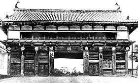 | 38°15′08″N 140°51′21″E | |
| Sendai Castle Sumi-yagura 仙台城隅櫓 Sendai-jō sumi-yagura | Edo period | Sendai | 14 December 1931 | 10 July 1945 (air raid of 10 July 1945) | corner tower, part single storey, part two storey |  | 38°15′08″N 140°51′21″E |
| Ōgaki Castle 大垣城 Ōgaki-jō | Momoyama to Edo period | Ōgaki | 20 April 1936 | 29 July 1945 (fire from air raid) | two structures, each with two associated structures: four-storey tenshu, with associated connecting west and east wings (天守附西附多門、東附多門); and two-storey northeast corner tower, with associated wings (良隅櫓附先手武多門、宗門多門) | .jpg) .jpg) | 35°21′43″N 136°36′58″E |
| Nagoya Castle 名古屋城 Nagoya-jō | Momoyama to Edo period | Nagoya | 11 December 1930 | Lost in air raid of 14 July 1945 | twenty structures |  | 35°11′02″N 136°54′01″E |
| Wakayama Castle 和歌山城 Wakayama-jō | Edo period | Wakayama | 13 May 1935 | Lost in air raid of 9 July 1945 | eleven structures | 34°13′39″N 135°10′17″E | |
| Okayama Castle Tenshu 岡山城天守 Okayama-jō tenshu | Momoyama period | Okayama | 19 January 1931 | Lost in air raid of 29 June 1945 | six-storey tenshu with connecting storehouse |  | 34°39′54″N 133°56′10″E |
| Okayama Castle Ishiyamamon 岡山城石山門 (渋蔵門) Okayama-jō ishiyamamon (shibukuramon) | Momoyama period | Okayama | 19 January 1931 | Lost in air raid of 29 June 1945 | 34°39′54″N 133°56′10″E | ||
| Hiroshima Castle Tenshu 広島城天守 Hiroshima-jō tenshu | Momoyama period | Hiroshima | 19 January 1931 | Lost in atomic bombing of 6 August 1945 | five-storey tenshu with connecting tower |  | 34°24′05″N 132°27′34″E |
| Matsuyama Castle 松山城 Matsuyama-jō | Edo period | Matsuyama | 13 May 1935 | 26 July 1945 (fire from air raid) 27 February 1949 (fire) | fourteen structures; lost in 1945: Tenjin-yagura, Bagu-yagura, Taiko-yagura, Tatsumi-yagura, Inuimon, Higashi-Tsuzuki-yagura of Inuimon, Taiko-mon, Tsuzuki-yagura of Taikomon, West Wall of Inuimon, East Wall of Taikomon, West Wall of Taikomon; lost in 1949: Tsutsuimon, Higashi-Tsuzuki-yagura of Tsutsuimon, Nishi-Tsuzuki-yagura of Tsutsuimon | 33°50′44″N 132°45′56″E | |
| Uwajima Castle Ōtemon 宇和島城追手門 Uwajima-jō ōtemon | Edo period | Uwajima | 30 January 1934 | 13 July 1945 (fire from air raid) | .jpg) | 33°13′09″N 132°34′04″E | |
| Shuri Castle Shureimon 首里城守礼門 Shuri-jō shureimon | Muromachi period | Naha (former Shuri) | 23 January 1933 | c.12 May 1945 (battle) | .jpg) | 26°13′05″N 127°43′01″E | |
| Shuri Castle Kankaimon 首里城歓会門 Shuri-jō kankaimon | Muromachi period | Naha (former Shuri) | 23 January 1933 | c.12 May 1945 (battle) | .jpg) | 26°13′04″N 127°43′04″E | |
| Shuri Castle Zuisenmon 首里城瑞泉門 Shuri-jō zuisenmon | Muromachi period | Naha (former Shuri) | 23 January 1933 | c.12 May 1945 (battle) | .jpg) | 26°13′03″N 127°43′05″E | |
| Shuri Castle Shiroganemon 首里城白銀門 Shuri-jō shiroganemon | Muromachi period | Naha (former Shuri) | 23 January 1933 | c.12 May 1945 (battle) | .jpg) | 26°13′02″N 127°43′14″E | |
Mausolea
15 properties
| Property | Date | Municipality | Date of designation | Date of loss | Comments | Image | Coordinates |
|---|---|---|---|---|---|---|---|
| Mausoleum of Date Masamune 伊達政宗霊廟 Date Masamune reibyō | 1637 | Sendai | 14 December 1931 | 10 July 1945 (fire from air raid) | seven structures: Zuihōden (瑞鳳殿), Karamon (唐門), Sukibei (透塀) (fence), South Corridor (南廊下), Haiden (拝殿), Hashi (橋), Gokusho (御供所), Connecting Corridor (繋廊下), Nehan-mon (涅槃門) | 38°15′03″N 140°51′56″E | |
Miscellaneous structures
1 property
| Property | Date | Municipality | Date of designation | Date of loss | Comments | Image | Coordinates |
|---|---|---|---|---|---|---|---|
| Ishioka First Power Plant Water Tank 石岡第一発電所施設 水槽 Ishioka dai-ichi hatsudensho shisetsu suisō | Meiji period | Kitaibaraki | 2 October 2008 | 11 March 2011 (2011 Tōhoku earthquake) | 36°47′31″N 140°39′15″E | ||
Shrines
19 properties
Temples
40 properties
Residences
9 properties
| Property | Date | Municipality | Date of designation | Date of loss | Comments | Image | Coordinates |
|---|---|---|---|---|---|---|---|
| Hanyū Family Residence 羽生家住宅(茨城県新治郡八郷町) Hanyū-ke jūtaku | Edo period | Ishioka (formerly Yasato) | 3 February 1976 | 25 February 1993 (fire) | two structures: Main House (主屋, Omoya) and House for the Old Master (隠居所, Inkyo-jo); designation included associated plans (家相図) | 36°12′28″N 140°09′28″E | |
| Omotemon (Former Satsuma Mansion Gate) 表門(旧薩摩装束屋門) Omotemon (kyū-Satsuma shōzoku yashiki mon) | Edo period | Chiyoda | 14 December 1931 | 25 May 1945 (air raid) | from the Tokyo residence of the Shimazu clan, former daimyō of the Satsuma Domain | ||
Works of Fine Art
74 properties
Paintings
12 properties
| Property | Date | Municipality | Ownership | Date of designation | Date of loss | Comments | Image | Coordinates |
|---|---|---|---|---|---|---|---|---|
| Pictorial Biography of Ippen Shōnin, colour on paper 紙本着色一遍上人絵詞伝 shihon chakushoku Ippen shōnin ekotoba den | Kamakura period | Fujisawa | Shōjōkō-ji | 1 August 1899 | 6 July 1911 (fire) | ten scrolls | 35°20′54″N 139°29′19″E | |
| Nagoya Castle Honmaru Palace wall and sliding-door paintings 名古屋城本丸御殿障壁画 Nagoya-jō honmaru goten shōhekiga | Momoyama to Edo period | Nagoya | Nagoya City (kept at Nagoya Castle) | 26 June 1942 | 4 May 1945 (fire from air raid) | ninety-five panels; other panels had been removed for safekeeping; three hundred and thirty-one surviving panels have been designated an Important Cultural Property[3] | .JPG) | 35°11′02″N 136°54′01″E |
| Portrait of Tōdō Takatora, colour on silk 絹本着色藤堂高虎像 shihon chakushoku Tōdō Takatora zō | Edo period | Tsu | Kanshō-in (寒松院) | 14 April 1906 | 18 July 1945 (fire from air raid) | inscribed by Tenkai (replica pictured) | _(replica).jpg) | 34°42′53″N 136°30′53″E |
| Willows and Reeds & Loquats, colour on gold ground 金地着色柳及蘆図・枇杷図 kinji chakushoku yanagi oyobi ashi zu・biwa zu | Momoyama period | Kyōto | Chishaku-in | 8 August 1919 | 17 May 1947 (fire) | ten panels; wall and sliding-door paintings from the Shinden Higashi-no-ma | 34°59′17″N 135°46′33″E | |
| Bamboo & Hinoki and Daimyō Oaks, colour on gold ground 金地着色竹図・檜及柏図 kinji chakushoku take zu・hinoki oyobi kashiwa zu | Momoyama period | Kyōto | Chishaku-in | 8 August 1919 | 17 May 1947 (fire) | six panels; wall and sliding-door paintings from the Shinden Nishi-no-ma | 34°59′17″N 135°46′33″E | |
| Wall and sliding-door paintings from the Hōjō 方丈障壁画 hōjō shōhekiga | 1641 | Kyōto | Daitoku-ji | 5 September 1944 | 20 July 1966 (fire) | one of the eighty-four panels was lost; ink on paper, by Kanō Tan'yū; although the record was updated, designation has continued (now an Important Cultural Property)[4] | 35°02′38″N 135°44′46″E | |
Sculptures
34 properties
| Property | Date | Municipality | Ownership | Date of designation | Date of loss | Comments | Image | Coordinates |
|---|---|---|---|---|---|---|---|---|
| Seated Wooden Statue of Priest Motsugai 木造物外和尚座像 mokuzō Motusgai oshō zazō | 1370 | Tachikawa | Fusai-ji (普済寺) | 14 April 1913 | 4 April 1995 (fire) | 35°41′26″N 139°24′06″E | ||
Crafts
16 properties
| Property | Date | Municipality | Ownership | Date of designation | Date of loss | Comments | Image | Coordinates |
|---|---|---|---|---|---|---|---|---|
| Bronze Bell 銅鐘 dōshō | Goryeo | Naha | Naminoue-gū | 27 May 1907 | Lost in fire, 1945 | .jpg) | 26°13′13″N 127°40′17″E | |
Calligraphic works
10 properties
| Property | Date | Municipality | Ownership | Date of designation | Date of loss | Comments | Image | Coordinates |
|---|---|---|---|---|---|---|---|---|
| Engi-shiki, ink on paper 紙本墨書延喜式 shihon bokusho Engi-shiki | Heian period | Shinjuku | private | 30 January 1934 | 10 March 1945 (fire from air raid of 10 March 1945) | five scrolls (vols 1–5) | 35°41′46″N 139°44′02″E | |
| Notes on the Doctrines of the Kegon Sutra, ink on paper 紙本墨書華厳文義要決 shihon bokusho Kegon mongi yōketsu | Heian period | Shinjuku | private | 4 July 1938 | 14 April 1945 (fire from air raid) | volume one, with the Tōdaiji Fujumonkō on the back | 35°40′55″N 139°43′12″E | |
| Lotus Sutra, ink on paper 紙本墨書法華経 shihon bokusho Hoke-kyō | 1352 | Kamakura | Zokutō-an (続燈庵) (subtemple of Engaku-ji) | 4 April 1905 | 1 September 1923 (fire from Great Kantō earthquake) | one scroll, in the hand of Ashikaga Takauji | 35°20′21″N 139°32′58″E | |
| Writing in the hand of Retired Emperor Kōmyō-in, ink on paper 紙本墨書光明院宸翰 shihon bokusho Kōmyō-in shinkan | Nanboku-chō period | Fukui | Asuwa Jinja (足羽神社) | 7 April 1900 | 19 July 1945 (fire from air raid of 19 July 1945) | 36°03′31″N 136°12′35″E | ||
| Writing in the hand of Emperor Ninkō, ink on paper 紙本墨書仁孝天皇宸翰 shihon bokusho Kōmyō-in shinkan | late Edo period | Fukui | Asuwa Jinja (足羽神社) | 7 April 1900 | 19 July 1945 (fire from air raid of 19 July 1945) | 36°03′31″N 136°12′35″E | ||
| Taiheiki, ink on paper 紙本墨書太平記 shihon bokusho Taiheiki | Muromachi period | Kyōto | Ryōan-ji | 5 April 1909 | 18 March 1929 (fire) | one scroll lost of the thirteen; although the record was updated, designation has continued (now an Important Cultural Property)[5] | 35°02′04″N 135°43′06″E | |
| Lotus Sutra, ink on paper 紙本墨書法華経 shihon bokusho Hoke-kyō | 1689 | Yawata | Iwashimizu Hachimangū | 30 April 1935 | 12 February 1947 (fire) | eight scrolls, in the hand of Princess Tsuneko (常子内親王) | 34°52′47″N 135°42′00″E | |
| Yuiitsu Shinron, ink on paper 紙本墨書唯一神論 shihon bokusho Yuiitsu Shinron | Tang | Kōbe | private | 23 January 1923 | 12 March 1945 (fire from air raid) | one scroll, from a Tang translation of a Christian text; from Dunhuang; cf. Jingjiao Documents | 34°42′47″N 135°15′40″E | |
| Documents of Seinan-in 西南院文書 Seinan-in monjo | Kamakura to Edo period | Kōya | Seinan-in (西南院) | 18 December 1959 | 18 December 1969 (fire) | four of the eleven scrolls were damaged; although the record was updated, designation has continued (now an Important Cultural Property)[6] | 34°12′46″N 135°34′30″E | |
| Anthology of Poems in Memory of the Wars between the Taira and the Minamoto, ink on paper 紙本墨書懐古詩歌帖 shihon bokusho Kaikoshi kajō | Muromachi to Edo period | Shimonoseki | Akama-gū | 14 April 1906 | 2 July 1945 (fire from air raid) | one volume | 33°57′34″N 130°56′55″E | |
Stone monuments
2 properties
| Property | Date | Municipality | Ownership | Date of designation | Date of loss | Comments | Image | Coordinates |
|---|---|---|---|---|---|---|---|---|
| Stele (Ankokuzan Jukaboku no Ki) 石碑(安国山樹華木之記) seki-hi (Ankokuzan jukaboku no ki) | 1427 | Naha (formerly Shuri) | Shuri City | 25 October 1937 | 1945 | erected by King Shō Hashi in 1427, the inscription records the planting of trees and flowers on Ankoku Hill, formed with fill from the digging of Ryūtan pond;[7] the stele was badly damaged in 1945; kept at Okinawa Prefectural Museum, it is scheduled to be re-designated an Important Cultural Property in Autumn 2019[8] | 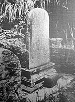 | 26°13′05″N 127°43′02″E |
| Stone Signposts 石標 seki-hyō | 1527 | Naha (formerly Shuri) | Shuri City | 25 October 1937 | 1945 | a pair of stelai inscribed with the injunction to dismount from one's horse; formerly flanking the entrance to Sōgen-ji, only one survived the battle of Okinawa | .jpg) | 26°13′13″N 127°41′26″E |
See also
| Wikimedia Commons has media related to Former Cultural Properties of Japan. |
References
- Agency for Cultural Affairs, ed. (2003). 戦災等による焼失文化財―20世紀の文化財過去帳 [Cultural Properties Lost to Fire during War etc: a register of former twentieth-century cultural properties] (in Japanese). 戎光祥出版. ISBN 4-900901-34-2.
- Agency for Cultural Affairs, ed. (2017). 戦災等による焼失文化財 2017 [Cultural Properties Lost to Fire during War etc 2017] (in Japanese). 戎光祥出版. ISBN 978-4864032414.
- 名古屋城旧本丸御殿障壁画 [Former Nagoya Castle Honmaru Palace Wall and Sliding-door Paintings] (in Japanese). Agency for Cultural Affairs. Retrieved 4 September 2019.
- 方丈障壁画狩野探幽筆 [Wall and sliding-door paintings from the Hōjō, by Kanō Tan'yū] (in Japanese). Agency for Cultural Affairs. Retrieved 4 September 2019.
- 太平記 [Taiheiki] (in Japanese). Agency for Cultural Affairs. Retrieved 4 September 2019.
- 西南院文書 [Documents of Seinan-in] (in Japanese). Agency for Cultural Affairs. Retrieved 4 September 2019.
- Pearson, Richard (2013). Ancient Ryukyu: an Archaeological Study of Island Communities. University of Hawai'i Press. pp. 239 f. ISBN 978-0824837129.
- 国重文に琉球国時代の石碑 沖縄県内から3件指定へ 伊江家資料・八重山蔵元の画稿も [3 Properties to be Designated Important Cultural Properties: Inscribed Stelai from the Time of the Ryūkyū Kingdom, Ie Family Materials, Yaeyama Kuramoto Sketches]. Okinawa Times. 19 March 2019. Retrieved 4 September 2019.
This article is issued from Wikipedia. The text is licensed under Creative Commons - Attribution - Sharealike. Additional terms may apply for the media files.