Langøya
Langøya is the third largest island of Norway (outside of Svalbard), with an area of 850.2 square kilometres (328.3 sq mi). The island is a part of the Vesterålen archipelago in Nordland county, Norway. The island includes the municipalities of Bø and Øksnes as well as parts of the municipalities of Sortland and Hadsel.
 | |
 Langøya Location of the island  Langøya Langøya (Norway) | |
| Geography | |
|---|---|
| Location | Nordland, Norway |
| Coordinates | 68.6220°N 14.9407°E |
| Archipelago | Vesterålen |
| Area | 850.2 km2 (328.3 sq mi) |
| Area rank | 3rd largest in Norway |
| Length | 50 km (31 mi) |
| Width | 40 km (25 mi) |
| Highest elevation | 763 m (2,503 ft) |
| Highest point | Snøkolla |
| Administration | |
Norway | |
| County | Nordland |
| Municipalities | Bø, Hadsel, Sortland, and Øksnes |
| Demographics | |
| Population | 15,791 (2016) |
| Pop. density | 18.6/km2 (48.2/sq mi) |
The large island of Hinnøya lies to the east (on the other side of the Sortlandssundet). The island of Andøya lies to the northeast. The small island of Skogsøya lies to the northwest. The island of Hadseløya lies to the south. There are several lakes on the island including Alsvågvatnet. The Eidsfjorden divides the island almost in half. The island has two road bridges connecting it to Hadseløya and Hinnøya via the Hadsel Bridge and Sortland Bridge.[1]
Media gallery
 The rugged western part of Langøya near Nykvåg.
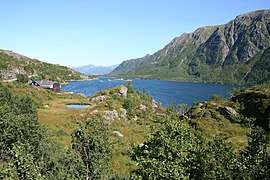 Lifjorden; many small fjords dissect Langøya
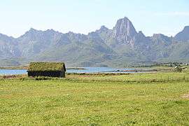 View near Frøskeland
 Map of the area