Lake of Sainte-Croix
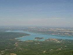
The Lake of Sainte-Croix (French: lac de Sainte-Croix) is a man-made lake that was formed by the construction, between 1971 and 1974 (when it was put into service) of a reinforced-concrete arch dam by the name of Dam of Sainte-Croix. The reservoir holds a maximum of 761 million cubic metres of water. The dam, which generates 142 million kWh of electricity per year, is 94 metres high, 7.5 metres thick at its base and 3 metres thick at its crest.
| Lac de Sainte-Croix | |
|---|---|
 | |
| Location | Var/Alpes-de-Haute-Provence |
| Coordinates | 43°45′49″N 6°11′2″E |
| Type | reservoir |
| Primary inflows | Verdon River |
| Primary outflows | Verdon River |
| Catchment area | 1,591 km2 (614 sq mi) |
| Basin countries | France |
| Surface area | 22 km2 (8.5 sq mi) |
| Max. depth | 93 m (305 ft) |
| Water volume | 760×106 m3 (27×109 cu ft) |
| Surface elevation | 477 m (1,565 ft) |
| Settlements | Les Salles-sur-Verdon, Sainte-Croix-du-Verdon, Bauduen |
The village that can be seen adjacent to the lake, however, is not the eponymous village of Sainte-Croix-de-Verdon but Les Salles-sur-Verdon. The original village is now completely underwater.
The other villages around the lake are:
- Sainte-Croix-du-Verdon
- Bauduen
- Les Salles-sur-Verdon (new village)
Lac de Sainte-Croix
See also
External links
- Sainte Croix Lake (in French)
- Sainte Croix Lake (in English)
- Guide tour of the Lake of Sainte-Croix (in French)

This article is issued from Wikipedia. The text is licensed under Creative Commons - Attribution - Sharealike. Additional terms may apply for the media files.