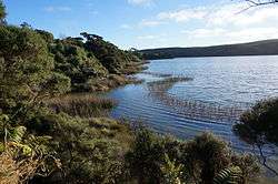
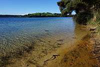
Lake Rototoa
Lake Rototoa is a lake located at the northern end of the south head of the Kaipara Harbour in the Rodney District of Auckland Region, New Zealand.[2] With a surface area of 1.39 km2 and a maximum depth of 26 m, it is the largest and deepest of a series of sand-dune lakes found along the western coastline of the North Island.[3]
| Lake Rototoa | |
|---|---|
 | |
| Location | Auckland Region, North Island |
| Coordinates | 36.5135°S 174.2375°E |
| Basin countries | New Zealand |
| Surface area | 1.39 km2 (0.54 sq mi)[1] |
| Max. depth | 26 m (85 ft) |
Previously known as Lake Ototoa, its name was changed in 2013.[4] Rototoa translates as 'Lake of the Warrior', and is part of a line of lakes known as 'the Footsteps of Kawharu' after the warrior Kawharu who fought with the Ngati Whatua tribe against the resident Waiohua, Ngaririki and Kawerau tribes in the late 17th to early 18th centuries.[5]
Lake Rototoa
See also
- List of lakes in New Zealand
References
- Rowe, D. K. "Distribution and conservation status of the dwarf inanga Galaxias gracilis (Teleostei: Galaxiidae) an endemic fish of Northland dune lakes" (PDF). Journal of The Royal Society of New Zealand, Vol. 27, Nr. 2, June 1997, p. 231. Archived from the original (PDF) on 21 July 2011. Retrieved 9 October 2010.
- "Place name detail: Lake Rototoa". New Zealand Gazetteer. Land Information New Zealand. Retrieved 17 March 2018.
- New Zealand. Dept. of Scientific and Industrial Research, (1976). New Zealand journal of marine and freshwater research, Vol. 10, p. 43. ISSN 0028-8330
- http://www.legislation.govt.nz/act/public/2013/0037/latest/DLM4653300.html?search=qs_act_wahi+tapu_noresel_25_a&p=2
- http://teaohou.natlib.govt.nz/journals/teaohou/issue/Mao40TeA/c19.html
This article is issued from Wikipedia. The text is licensed under Creative Commons - Attribution - Sharealike. Additional terms may apply for the media files.