Lake Rotoehu
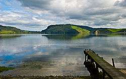
Lake Rotoehu is the smallest in a chain of three lakes to the northeast of Lake Rotorua in New Zealand's North Island. It is located between the city of Rotorua and town of Whakatane. The southern end of the lake occupies part of the Okataina caldera. It is fed (underground seepage) by Lake Rotoma to the east, and flows westward joining Lake Rotoiti. The lake is one of the least visited, but offers great Kayaking and fishing (rainbow trout). It has two access points, Otautu Bay and Kennedy bay and is well located centrally to many other places e.g. the ocean, mountain biking, hiking etc. It has very good wildlife and birdlife with several rarely seen birds. In particular the endangered Kokako is located close by.
| Lake Rotoehu | |
|---|---|
 | |
| Location | North Island |
| Coordinates | 38°1′S 176°32′E |
| Type | crater lake |
| Primary outflows | sink hole in the northern arm |
| Basin countries | New Zealand |
| Max. length | 4.6 km (2.9 mi)[1] |
| Max. width | 4.0 km (2.5 mi)[1] |
| Surface area | 8.1 km2 (3.1 sq mi)[1] |
| Average depth | 8.3 m (27 ft)[1] |
| Max. depth | 13.5 m (44 ft)[1] |
| Surface elevation | 295 m (968 ft)[1] |
| Islands | nil |
| Settlements | Otautu Bay and Kennedy Bay- Rotorua 30km away |
| References | [1] |
The New Zealand Ministry for Culture and Heritage gives a translation of "turbid lake" for Rotoehu.[2]
References
- Lowe, D.J., Green, J.D. (1987). Viner, A.B. (ed.). Inland waters of New Zealand. Wellington: DSIR Science Information Publishing Centre. pp. 471–474. ISBN 0-477-06799-9.CS1 maint: multiple names: authors list (link)
- "1000 Māori place names". New Zealand Ministry for Culture and Heritage. 6 August 2019.
External links
| Wikimedia Commons has media related to Lake Rotoehu. |
- Rotoma-Rotoehu Resident and Ratepayers Assn A website for the area