Labuha
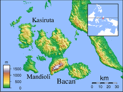
Labuha is a small port town on the eastern Indonesian island of Pulau Bacan. It is the capital of the South Halmahera Regency, part of the province of North Maluku. The town is served by Labuha Airport.
Labuha | |
|---|---|
Town | |
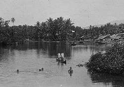 Children swimming in the vicinity of Labuha in the 1930s | |
| Coordinates: 0°37′40″S 127°28′50″E | |
| Country | Indonesia |
| Region | Maluku |
| Province | North Maluku |
| Regency | South Halmahera Regency |
| Time zone | UTC+9 (IEST) |
| Postcode | 97791 |
| Area code | (+62) 929 |
Climate
Labuha has a tropical rainforest climate (Af) with moderate to heavy rainfall year-round.
| Climate data for Labuha | |||||||||||||
|---|---|---|---|---|---|---|---|---|---|---|---|---|---|
| Month | Jan | Feb | Mar | Apr | May | Jun | Jul | Aug | Sep | Oct | Nov | Dec | Year |
| Average high °C (°F) | 30.0 (86.0) |
30.1 (86.2) |
30.1 (86.2) |
30.5 (86.9) |
30.1 (86.2) |
29.8 (85.6) |
29.2 (84.6) |
29.7 (85.5) |
30.0 (86.0) |
30.3 (86.5) |
31.1 (88.0) |
30.1 (86.2) |
30.1 (86.2) |
| Daily mean °C (°F) | 26.5 (79.7) |
26.6 (79.9) |
26.6 (79.9) |
26.9 (80.4) |
26.8 (80.2) |
26.6 (79.9) |
26.1 (79.0) |
26.4 (79.5) |
26.3 (79.3) |
26.5 (79.7) |
27.3 (81.1) |
26.6 (79.9) |
26.6 (79.9) |
| Average low °C (°F) | 23.1 (73.6) |
23.2 (73.8) |
23.2 (73.8) |
23.4 (74.1) |
23.5 (74.3) |
23.5 (74.3) |
23.1 (73.6) |
23.1 (73.6) |
22.7 (72.9) |
22.7 (72.9) |
23.6 (74.5) |
23.1 (73.6) |
23.2 (73.8) |
| Average rainfall mm (inches) | 187 (7.4) |
175 (6.9) |
193 (7.6) |
164 (6.5) |
154 (6.1) |
148 (5.8) |
165 (6.5) |
134 (5.3) |
105 (4.1) |
103 (4.1) |
133 (5.2) |
180 (7.1) |
1,841 (72.6) |
| Source: Climate-Data.org[1] | |||||||||||||
References
- "Climate: Labuha". Climate-Data.org. Retrieved August 9, 2020.
Regencies and cities of North Maluku | ||
|---|---|---|
Capital: Sofifi | ||
| Regencies | ||
| Cities | ||
This article is issued from Wikipedia. The text is licensed under Creative Commons - Attribution - Sharealike. Additional terms may apply for the media files.