Kiwira River
Kiwira River is a river of Mbeya Region, Tanzania.
| Kiwira River | |
|---|---|
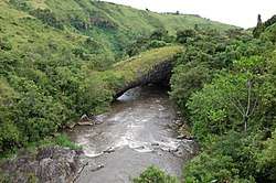 Daraja la Mungu, a natural bridge spanning Kiwira River west of Tukuyu | |
 Kiwira river (top left) | |
| Location | |
| Country | Tanzania |
| Region | Mbeya |
| Physical characteristics | |
| Source | Mount Rungwe, Poroto Mountains |
| 2nd source | Marogala Stream |
| 3rd source | Sinini Stream |
| 4th source | Kipoke Stream |
| 5th source | Kilasi Stream |
| Mouth | Lake Malawi |
Course
It rises in the Poroto Mountains southeast of Mbeya and receives several streams originating on the slopes of Mount Rungwe, including the Marogala, Sinini, Kipoke, Kilasi and Mulagala.[1] Kijungu Falls is on the upper course of the river. It then flows southeast and empties into the northern end of Lake Malawi near the town of Kyela.[2] The lower course flows through the Kyela Plain, which sits northwest of Lake Malawi in the valley of the East African Rift. The Kyela Plain is cultivated intensively with rice and other crops.[3]
Daraja la Mungu
Daraja la Mungu (Swahili: "Bridge of God") is a natural bridge that spans the Kiwira River at 9.27703°S 33.55185°E, reputedly formed less than a thousand years ago by a lava flow from Mount Rungwe. It can be viewed from a man-made bridge crossing the river 500 m upstream.[4]
References
- "Rungwe Mountain Catchment Reserve". Utalii Travel & Safaris. Retrieved 4 June 2017.
- Sheet SC 36-2: Mbeya (Map). 1:500,000. Series Y401. US Army Map Service. 1958. Retrieved 4 June 2017.
- Racaud, Sylvain, and Francois Bart (2017). "Rural-Urban Dynamics in the East African Mountains" Mkuki na Nyota Publishers, 2017
- Briggs, Philip; Wildman, Kim (2009). Tanzania: With Zanzibar, Pemba and Mafia. Bradt Travel Guides. p. 529. ISBN 9781841622880. Retrieved 4 June 2017.