Kaw, French Guiana
Kaw or Caux (meaning marsh in French) is a village in the commune of Régina, in north-east French Guiana, situated on the banks of Approuague river. This is also a very swampy area.[1]
Kaw | |
|---|---|
Village | |
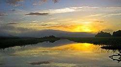 Sunset over the Kaw-Roura marshes | |
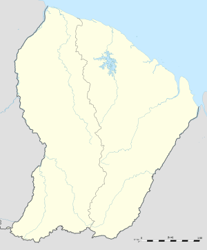 Kaw Location in French Guiana | |
| Coordinates: 4°29′12″N 52°2′13″W | |
| Country | France |
| Overseas region | French Guiana |
| Arrondissement | Cayenne |
| Commune | Régina |
Overview
The name Cô, Caubonne and Caux has appeared on old maps since the early 16th century. In 1783, Jean Samuel Guisan started to polder the Approuage river right up to the then indigenous village.[1] The establishment of the road to Roura,[2] and ecotourism strengthened the economy of the village which was largely dependent on hunting and fishing.[1]
In 1998, the Kaw-Roura Marshland Nature Reserve was established, and covers an area of 94,700 hectares between Roura and Régina,[3] and is sometimes nicknamed "the Everglades of Guyana".[1]
The village has a church,[4] a post office, a school,[5] and a rural clinic.[6]
References
- "Guide Kaw". Petit Futé (in French). Retrieved 1 June 2020.
- "Etude de la biodiversité et des paysages dans le cadre de l'aménagement et l'entretien de la route RD6, communes de Roura et Régina, Guyane" (PDF). Reserves Naturelles (in French). Retrieved 1 June 2020.
- "KAW-ROURA MARSHLANDS NATURE RESERVE". Petit Futé (in French). Retrieved 1 June 2020.
- "Diocèse de Cayenne". Guyane Catholique (in French). Retrieved 1 June 2020.
- "Ecole élémentaire Kaw (97353, Régina)". Journal des Femmes (in French). Retrieved 1 June 2020.
- "Centre Hospitalier Cayenne médecin ORL". Info Medecin (in French). Retrieved 1 June 2020.
External links
| Wikimedia Commons has media related to Réserve naturelle nationale des marais de Kaw-Roura. |