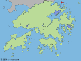
Kat O
Kat O, also named Crooked Island, is an island in Northeast Hong Kong. Administratively, it is part of North District.
Geography
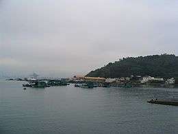
Kat O is located in the west of Mirs Bay.[1] With an area of 2.35 km²,[2] it is the largest island in North District, the second largest being Wong Wan Chau (Double Island).[3] Neighbouring islands include: Ap Chau, Ngo Mei Chau (Crescent Island), and Pak Sha Chau (Round Island). The village of Tung O (東澳) is located on its northwest coast.[3] Its highest point is Kai Kung Leng (雞公嶺), which is 122 m above sea level.[1]
History
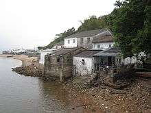
Kat O was once a major fishing market in Hong Kong.[4] Its residents were mostly Hakka and Tanka fishermen.[4]
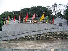
The Tin Hau Temple at Kat O was estimated to be built in 1763.[5] It is listed as a Grade III historic building.[6] Part of the temple building was used for the Tat O School until the school was moved to a new location in 1957.[4] A Pak Kung Shrine is also located in the vicinity.[7]
There are 3 cannons located on the island. They are estimated to be made in the west, during the 19th century.[7]
Conservation
Kat O was part of the Plover Cove (Extension) Country Park since 1979.[8]
The Kat O Nature Trail spans 1 km long, stretching from the Kat O Ferry Pier to Ko Tei Teng (高地頂).[1]
The Kat O Geoheritage Centre (at No. 142 Kat O Main Street) was opened in 2010[9] by Kat O villagers, volunteer groups and the government to raise public awareness of geo-conservation, as part of the Hong Kong Geopark.[10]
References
- Hong Kong Geopark: Kat O Nature Trail
- Survey and Mapping Office, Lands Department: Hong Kong geographic data sheet
- K.W. Lai, S.D.G. Campbell & R. Shaw, Geology of the Northeastern New Territories, p. 15, Civil Engineering Dept, Geotechnical Engineering Office, December 1996
- Antiquities Advisory Board. Historic Building Appraisal. Tin Hau Temple, Sai O, Kat O
- Welcome to 18 Districts - North District
- List of the 1,444 Historic Buildings with Assessment Results
- "Crooked Island". 2016-03-04. Archived from the original on 2016-03-04. Retrieved 2019-05-10.
- Agriculture, Fisheries and Conservation Department: Plover Cove Country Park Archived 2013-09-29 at the Wayback Machine
- Time Out Hong Kong: "Secret Hong Kong islands", 29 Apr 2014
- Hong Kong Geopark: Kat O Geoheritage Centre
External links
| Wikimedia Commons has media related to Crooked Island, Hong Kong. |
- Delineation of area of existing village Kat O (Sha Tau Kok) for election of resident representative (2019 to 2022)
- Kut-O Chinese Association (Kent area) Website
- Pictures of Kat O: ,
- Hong Kong Geopark: "Lee Yuk Ying Introduces the Cultural History of Kat O to Visitors".
- Webpage about Kat O
- Pictures of Tin Hau Temple, Sai O, Kat O