Kasol
Kasol is a hamlet in the district Kullu of the Indian state of Himachal Pradesh.[3][4] It is situated in Parvati Valley, on the banks of the Parvati River, on the way between Bhuntar and Manikaran. It is located 30 km from Bhuntar[5] and 3.5 km from Manikaran. Kasol is the Himalayan hotspot for backpackers.[6] and acts as a base for nearby treks to Malana and Kheerganga. It is called Mini Israel of India due to a high percentage of Israeli tourists here.[7]
Kasol | |
|---|---|
Hill Station | |
 Kasol Mountain View | |
| Nickname(s): Mini Israel of India | |
 Kasol Location in Himachal Pradesh, India  Kasol Kasol (India) | |
| Coordinates: 32°00′35″N 77°18′55″E | |
| Country | |
| State | Himachal Pradesh |
| District | Kullu |
| Area | |
| • Total | 0.36 km2 (0.14 sq mi) |
| Elevation | 1,580 m (5,180 ft) |
| Language | |
| • Official | Hindi[1] |
| • Additional official | Sanskrit[2] |
| Time zone | UTC+5:30 (IST) |
| Telephone code | 01907 |
| Vehicle registration | HP- HP- |
| Nearest city | Kullu |
| Literacy | Low% |
| Climate | cool (Köppen) |
Climate
Kasol has good weather throughout the year and receives a fair amount of snowfall from late December to February. Köppen-Geiger climate classification system classifies its climate as humid subtropical (Cfa).[8]
| Climate data for Kasol, Himachal Pradesh | |||||||||||||
|---|---|---|---|---|---|---|---|---|---|---|---|---|---|
| Month | Jan | Feb | Mar | Apr | May | Jun | Jul | Aug | Sep | Oct | Nov | Dec | Year |
| Average high °C (°F) | 11.6 (52.9) |
14.2 (57.6) |
18.8 (65.8) |
24 (75) |
28.2 (82.8) |
29.3 (84.7) |
25.9 (78.6) |
25 (77) |
24.6 (76.3) |
22.2 (72.0) |
18.3 (64.9) |
14.2 (57.6) |
21.4 (70.4) |
| Daily mean °C (°F) | 7.4 (45.3) |
9.7 (49.5) |
14 (57) |
18.7 (65.7) |
22.9 (73.2) |
24.3 (75.7) |
22.3 (72.1) |
21.7 (71.1) |
20.6 (69.1) |
17.5 (63.5) |
13.3 (55.9) |
9.7 (49.5) |
16.8 (62.3) |
| Average low °C (°F) | 3.2 (37.8) |
5.2 (41.4) |
9.2 (48.6) |
13.4 (56.1) |
17.6 (63.7) |
19.4 (66.9) |
18.8 (65.8) |
18.4 (65.1) |
16.7 (62.1) |
12.8 (55.0) |
8.4 (47.1) |
5.3 (41.5) |
12.4 (54.3) |
| Average precipitation mm (inches) | 111 (4.4) |
108 (4.3) |
155 (6.1) |
103 (4.1) |
100 (3.9) |
93 (3.7) |
324 (12.8) |
276 (10.9) |
160 (6.3) |
70 (2.8) |
27 (1.1) |
55 (2.2) |
1,582 (62.6) |
| Source: Climate-Data.org (altitude: 1582m)[8] | |||||||||||||
Transport
There are different transport options available to reach Kasol. To reach Kasol one must first reach Bhuntar from where one has the option to use the Bus service which is available hourly and is available only between 8 AM to 6 PM. However, the local Taxi Service is available all the times. Bhuntar also has the nearest Kullu–Manali Airport (IATA: KUU, ICAO: VIBR). Kasol, being a tourist destination in the region, has frequent local bus service running from Manali.[9] There is no direct flight or rail connectivity to Kasol.[10]
Festivals
Kasol Music Festival is a music festival which happens in Kasol on every New Year's Eve. People from around the world gather for this festival.[11]
Gallery
 Kasol Valley forest camping
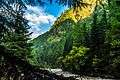 Kasol Riverside village
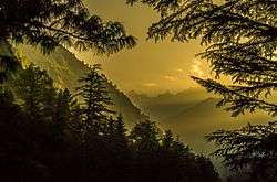
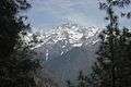 Himalayan Region view from Kasol
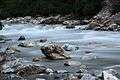 Parvati River
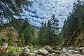 Parvati Valley, Himachal Pradesh
.jpg) Himalayan Bulbul spotted
Himalayan Bulbul spotted Parvati River in between Kasol mountains
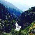 Kheerganga Trek route
 Parvati Valley amazing view
 Panorama of Kasol mountains
| Wikimedia Commons has media related to Kasol. |
References
- "Report of the Commissioner for linguistic minorities: 52nd report (July 2014 to June 2015)" (PDF). Commissioner for Linguistic Minorities, Ministry of Minority Affairs, Government of India. pp. 33–34. Archived from the original (PDF) on 28 December 2017. Retrieved 16 February 2016.
- Pratibha Chauhan (17 February 2019). "Bill to make Sanskrit second official language of HP passed". The Tribune. Shimla. Archived from the original on 18 February 2019. Retrieved 18 February 2019.
- "Kasol Kheerganga trek".
- "Untitled Page". nrega.nic.in. Retrieved 6 February 2020.
- "Google Maps". Google Maps. Retrieved 7 June 2017.
- "Kheerganga trek".
- "Why Israeli tourists in Kasol, called mini-Israel, are euphoric about Modi's visit". India Today. Retrieved 6 February 2020.
- "Kasol - Climate graph, Temperature graph, Climate table". Climate-Data.org. Retrieved 10 March 2016.
- "My first trip to India - Kasol & Tosh". Retrieved 25 May 2017.
- "How to Reach KASOL?". Retrieved 9 December 2017.
- "Make New Year vacation memorable: Plan a quick getaway to Kasol, Dandeli or Malshej". The Economic Times. 28 December 2017. Retrieved 7 April 2020.