Karlsøya, Troms
Karlsøya is an island in Karlsøy Municipality in Troms og Finnmark county, Norway. The 7.91-square-kilometre (3.05 sq mi) island of Karlsøya lies directly south of the island of Vannøya and northeast of the island of Reinøya, along the western side of the Ullsfjorden.[1] The one village area on the island is known as Karlsøy and in 2001, it had a population of 70.[2]
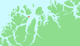 | |
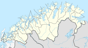 Karlsøya Location of the island  Karlsøya Karlsøya (Norway) | |
| Geography | |
|---|---|
| Location | Troms og Finnmark, Norway |
| Coordinates | 70.0065°N 19.9067°E |
| Area | 7.91 km2 (3.05 sq mi) |
| Length | 5 km (3.1 mi) |
| Width | 2 km (1.2 mi) |
| Highest elevation | 206 m (676 ft) |
| Highest point | Veten |
| Administration | |
Norway | |
| County | Troms og Finnmark |
| Municipality | Karlsøy Municipality |
The island was the centre of the prestegjeld and municipality of Karlsøy for many hundreds of years (hence the name of the municipality). The island is still the location of the historic Karlsøy Church. The name Karlsøy comes from the man's name Kalfr which comes from Kalven, formerly meaning "the little island which lies next to the bigger one" (referring to Vannøya).
See also
References
- "Karlsøya, Karlsøy" (in Norwegian). yr.no. Retrieved 2012-12-12.
- Statistisk sentralbyrå (2001). "Folke- og boligtellingen 2001, kommune- og bydelshefter 1936 Karlsøy" (PDF) (in Norwegian). Cite journal requires
|journal=(help)
External links
- Satellite picture of Karlsøya
- Flora of Karlsøya
- Karlsøy festival
- Svein-Egil Haugen: The homepage of Karlsøya
This article is issued from Wikipedia. The text is licensed under Creative Commons - Attribution - Sharealike. Additional terms may apply for the media files.