Kaloi Limenes
Kaloi Limenes or Kali Limenes (Greek: Καλοί Λιμένες [kaliˈ liménes]) is a village and port in the Heraklion regional unit, southern Crete, in Greece, located 82 kilometres (51 mi) south-west of the city of Heraklion. It has 21 inhabitants (2011).[1] It is known as a major bunkering spot for ships in the southern Mediterranean.[2]
Kaloi Limenes Καλοί Λιμένες | |
|---|---|
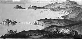 Panorama of Kaloi Limenes, painted by Thomas Abel Brimage Spratt, from Travels and researches in Crete (1865) | |
 Kaloi Limenes | |
| Coordinates: 34°55′46.9″N 24°48′01.1″E | |
| Country | Greece |
| Administrative region | Crete |
| Regional unit | Heraklion |
| Municipality | Faistos |
| Municipal unit | Moires |
| Population (2011)[1] | |
| • Rural | 21 |
| Time zone | UTC+2 (EET) |
| • Summer (DST) | UTC+3 (EEST) |
| Postal code | 700 09 |
| Area code(s) | 28920 |
History
Kaloi Limenes (meaning 'good harbors' or 'fair havens') is a natural port near the southernmost point of Crete. It is close to the village of Lentas (ancient Levin), and the unexcavated remains of Lassea, a port for the ancient settlement of Gortys.[3]
Biblical scholars [4] assert that Apostle Paul, in whose name a small church was built there (first in Byzantine times,[5] then restored in the 1960s), landed at Kaloi Limenes to preach the Christian faith in Crete. Other scholars claim that the commercial ship carrying Paul from Caesaria to Rome, as a prisoner of the Romans,[6] turned to the south of Crete to better sail under north-western winds and eventually had to take temporary refuge "at Fair Havens ... for a change in the wind."[7]
However, other historians and researchers[8] relate that Paul possibly landed further west, at Loutro, of the Sphakia region, where there is a chapel on the shore on which Paul is said to have baptized the first Cretan converts, or at Phoinikas ("Phoenix"), a small village in the bay west of Loutro.[9]
Bunkering
The port is the home of a major oil storage and terminal facility, located on the small island of Aghios Pavlos ("Saint Paul") at the port's entrance. The facility has four shore-based storage tanks containing fuel oil and gasoil, pumps of 1,000 cubic metres per hour capacity and three loading docks.[10] The terminal's maximum draft of 40 feet (13.45 metres)[10] enables the facility to handle oil tankers of up to approximately two hundred thousand metric tons of deadweight.[2]
Exact location
See also
| Wikimedia Commons has media related to Kali Limenes. |
Notes
- "Απογραφή Πληθυσμού - Κατοικιών 2011. ΜΟΝΙΜΟΣ Πληθυσμός" (in Greek). Hellenic Statistical Authority.
- Kali Limenes information Archived 2008-09-13 at the Wayback Machine from InfoMarine
- Prefecture of Heraklio: Kali Limenes from the Hellenic Resources Network
- "Bible Maps". Archived from the original on 2010-09-17. Retrieved 2010-05-12.
- Captain T.A.B. Spratt, Travels and Researches in Crete, 1865, II 1-6
- "Bible Study.org". Archived from the original on 2010-01-26. Retrieved 2010-05-12.
- White, Jefferson Evidence and Paul's Journeys, Chapter: "Caesarea to Fair Havens" Archived 2014-07-19 at the Wayback Machine, Parsagard Press, 2001, ISBN 978-0-9705695-0-9
- Llewellyn-Smith, Michael The Great Island, Longmans, 1965; online edition Sunshade Press, 2007. The ISBN printed in the document (978-0-95282-4-2) is invalid.
- Fielding, Xan The Stronghold: An Account of the Four Seasons in the White Mountains of Crete, Secker and Warburg, 1953: "St Paul landed at the village of Phoenix after barely escaping shipwreck on one of his many propaganda tours. And when he did land he barely escaped with his life, for he was looked on as a busybody and promptly beaten up. The preaching of the apostle could hardly have endeared him to such happy-go-lucky pagans. That, at least, is what they say in Loutro today: and I can well believe it."
- "O.W. Bunker & Seka to cooperate at Crete bunker station" Marine World, 22 January 2004
- World Port source