Isla Pérez
Isla Pérez is an island located in the Gulf of Mexico, 130 km (80.7 mi) north of Progreso, Mexico, off the coast of the Yucatán Peninsula. It belongs to the Arrecife Alacranes National Park, and is the largest island in the archipelago.[1][2]
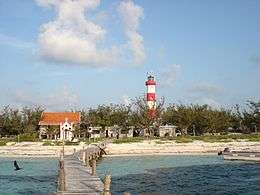 Entrance to the small port on Isla Pérez | |
Isla Pérez | |
| Geography | |
|---|---|
| Location | Gulf of Mexico |
| Coordinates | 22°23′40″N 89°42′00″W |
| Archipelago | Scorpion Reef |
| Administration | |
The waters and coral reefs surrounding the island provide an important refuge for sea life and attract many fishermen to the region. The island has little vegetation, with a hot and dry climate that is not hospitable to human life.[2]
Historically, the island has been used as a navigation reference point in the southern Gulf of Mexico, particularly for mariners between the Yucatán Channel and Bay of Campeche. Because of its importance to navigation, the Mexican Navy has stationed a small detachment there.[2][3]
See also
References
- "Arrecife Alacrán". GulfBase. Retrieved 13 April 2010.
- "Instituto Nacional de Ecología" (in Spanish). Parque Marino Nacional Arrecife Alacranes. Retrieved 13 April 2010.
- Yazmín Rodríguez Galaz (2008-06-28). "Se hunde embarcación en Isla Pérez de Yucatán". El Universal (in Spanish). Archived from the original on 2012-10-11. Retrieved 2010-12-27.
- Yucatán en el tiempo. Enciclopedia Alfabética. México 1998. ISBN 970-9071-04-1 (in Spanish)