Ingleside Plantation
Ingleside Plantation was a medium sized cotton plantation of 2,620 acres (1,060 ha) located in extreme northeast Leon County, Florida and established by Joel C. Blake.

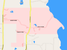
Location
Ingleside was bounded on the east by the shores of Lake Miccosukee and would have been bound on the west by Joel's mother's Blakely Plantation. Today, the land is County Road 59 (Veterans Memorial Drive). Ingleside's northern boundary would now be Cypress Landing Road and to the south it would have bounded by the streets of Leland Circle and Indigo Lane.
Plantation statistics
The Leon County Florida 1860 Agricultural Census shows that the Blakely Plantation had the following:
- Improved Land: 1,500 acres (610 ha)
- Unimproved Land: 1,140 acres (460 ha)
- Cash value of plantation: $25,000
- Cash value of farm implements/machinery: $1200
- Cash value of farm animals: $5,000
- Number of enslaved: 116
- Bushels of corn: 7000
- Bales of cotton: 181
The owner
Joel C. Blake was 29 years old in 1860. He married Laura Parish, some relation to his mother. Joel's Ingleside Plantation came into existence when Joel Blake purchased land to the east of Blakely Plantation. Blake joined the Confederacy and was killed on July 2, 1863 at the Battle of Gettysburg.
Ingleside would later become Ring Oak Plantation, a private hunting plantation co-owned by David Sinton Ingalls and Robert Livingston Ireland, Jr.
References
- Rootsweb Plantations
- Largest Slaveholders from 1860 Slave Census Sschedules
- Florida Historical Markers Program
- Paisley, Clifton; From Cotton To Quail, University of Florida Press, c1968.