Huhla Col
Huhla Col (Bulgarian: седловина Хухла, Sedlovina Huhla \se-dlo-vi-'na 'huh-la\) is the ice-covered col of elevation over 900 m on Trinity Peninsula in Graham Land, Antarctica, which is linking Snegotin Ridge to the north to the west part of Louis-Philippe Plateau to the south. It is overlooking Prelez Gap and Malorad Glacier to the west-northwest.
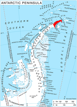
Location of Trinity Peninsula.
The col is named after the settlement of Huhla in Southern Bulgaria.
Location
Huhla Col is centred at 63°34′47″S 58°29′14″W. German-British mapping in 1996.
Maps
- Trinity Peninsula. Scale 1:250000 topographic map No. 5697. Institut für Angewandte Geodäsie and British Antarctic Survey, 1996.
- Antarctic Digital Database (ADD). Scale 1:250000 topographic map of Antarctica. Scientific Committee on Antarctic Research (SCAR). Since 1993, regularly updated.
gollark: Maybe it should only fire for a few caps messages in a minute or so?
gollark: What an excellent idea. I could PR it to esobot.
gollark: They probably mean the schism between apiologists and apiomemeticists. It's been quite bad.
gollark: This has nothing to do with me except that which is related to me of it.
gollark: That sounds quite bad.
References
- Huhla Col. SCAR Composite Antarctic Gazetteer
- Bulgarian Antarctic Gazetteer. Antarctic Place-names Commission. (details in Bulgarian, basic data in English)
External links
- Huhla Col. Copernix satellite image
This article includes information from the Antarctic Place-names Commission of Bulgaria which is used with permission.
This article is issued from Wikipedia. The text is licensed under Creative Commons - Attribution - Sharealike. Additional terms may apply for the media files.