Hogsmill River
The Hogsmill River in Surrey and Greater London, England is a small tributary of the River Thames. It rises in Ewell and flows into the Thames at Kingston upon Thames on the lowest typically non-tidal reach (that above Teddington lock). The river runs 6 miles (10 km) and has a catchment zone of about 73 km².[1] Nearby land was formerly flood-meadows; following improvements it is now mostly sports grounds, a sewage treatment works and green space, save for Kingston and Epsom town centres. It is a habitat of many animals, fish and insects.
| Hogsmill | |
|---|---|
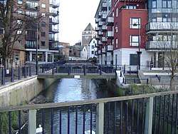 The Hogsmill at Kingston as it flows into the Thames | |
| Location | |
| Country | England |
| Counties | Surrey, Greater London |
| Districts / Boroughs | Epsom and Ewell, Royal Borough of Kingston upon Thames |
| Towns | Ewell, Old Malden, Berrylands, Kingston upon Thames |
| Physical characteristics | |
| Source | |
| • location | Ewell, Surrey |
| Mouth | River Thames |
• location | Kingston upon Thames |
• coordinates | 51°24′33″N 0°18′30″W |
| Length | 9.9 km (6.2 mi) |
| Basin size | 73 km2 (28 sq mi) |
| Discharge | |
| • location | Kingston upon Thames |
| • average | 0.98 m3/s (35 cu ft/s) |
| • minimum | 0.33 m3/s (12 cu ft/s)9 September 1976 |
| • maximum | 26.3 m3/s (930 cu ft/s)6 August 1981 |
| Discharge | |
| • location | Ewell |
| • average | 0.04 m3/s (1.4 cu ft/s) |
| Basin features | |
| Tributaries | |
| • left | Hogsmill Stream, Horton Stream, Bonesgate Stream, Green Lanes Stream, Tolworth Brook |
| • right | Ewell Court Stream |
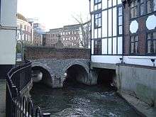
The 12th-century Clattern Bridge, one of the oldest road bridges in England, crosses the river in the southwest of Kingston town centre.[2] The Coronation Stone, now sited close to the river in Kingston, is believed to have been used for the coronation of Saxon kings in the 10th century. It was used as a horse mounting block until 1850 when it was mounted on a plinth in the town centre.
The river has five tributaries: Green Lanes Stream, Ewell Court Stream, Horton Stream, Bonesgate Stream and Tolworth Brook, as well as Hogsmill Stream, the main spring of the river just outside Bourne Hall Park in Ewell.
Course
Epsom and Ewell
The source of the Hogsmill River is a chalk spring near grid reference TQ219627 just outside Bourne Hall Park in Ewell, Surrey. It flows in a northerly direction between Kingston Road and the sports field beside the railway track. The river passes the Lower and Upper Mills, where gunpowder was produced in the 18th and 19th centuries, and gently bends to the left before flowing under the Mole Valley railway line between Ewell West and Stoneleigh railway station at the start of the Hogsmill Open Space which follows the river until the borough boundary with Kingston.
The river continues its course in green space between the residential areas of Ewell Court and West Ewell and joins the Green Lanes Stream. After a short distance of green space, the river runs as a boundary between Poole Road Recreation Ground and Ewell Court Park and flows behind Ewell Athletics Track. It reaches another confluence, this one being with the Ewell Court Stream, flowing in just downstream from Ewell Court Lake as it continues into West Ewell.
The river runs further through the open space and passes near West Ewell Infants School and Ruxley Church before flowing under Ruxley Farm Bridge, the site of the former Ruxley Splash. It passes Riverview Primary School in the residential area of Ruxley Ward before the confluence with the Bonesgate Stream, which is here the boundary between the boroughs of Epsom and Ewell (Surrey) and Kingston (Greatr London). After the confluence, the Hogsmill bends to the right near Riverview Road and continues as the boundary past Tolworth Court Bridge with the A240 (Kingston Road) to the junction with the B284 (Worcester Park Road).
Kingston
The river flows beside Worcester Park Road and Old Malden Lane (both the B284) along the edge of a few sports grounds and under the entrance to a go-carting track. The river leaves the boundary as it turns left into the outskirts of Old Malden in an area of woodland and green space. It crosses the Chessington branch railway line a short distance away from Malden Manor railway station. The Hogsmill is now flowing in a NNW direction as it crosses the A3 between Tolworth and Malden junctions.
The river delimits New Malden (historically the bulk of "Malden") and Berrylands (historically part of Kingston), beside sport and recreation grounds near Elmbridge Avenue, where it is joined by Tolworth Brook,[4] after which it passes under the South Western main railway line near Berrylands railway station. The Hogsmill leaves the green space area at the railway line and passes Kingsmeadow, Kingston Cemetery and sewage works in the eastern outskirts of Kingston upon Thames, which covers not only that borough but also Epsom and Ewell which had a large sewage farm against the river in the decades around 1900. It crosses under Villiers Road before heading past a campus of Kingston University before crossing Springfield Road beside Denmark Road and Grange Road. It also runs under the bridge for the A307 (Wheatfield Way) near College Roundabout beside Kingston College. The river then runs under St. James's Road by the Magistrates Court and the Guildhall before flowing under Kingston High Street and Wadbrook Street. The Hogsmill River meets the Thames beside a restaurant and street and promenade of shops beside the Thames Path footbridge at grid reference TQ177691, just upstream of Kingston Bridge.
Tributaries
Hogsmill Stream
Hogsmill Stream is the shortest out of the five main streams of the Hogsmill, running for 0.3 miles (0.5 km). It rises at the spring in Ewell and runs to the confluence with the Green Lanes stream between West Ewell and Ewell Court in the Hogsmill Open Space.
The source of the stream at Bourne Hall, Ewell Village is considered the main source of the Hogsmill River. However, other tributaries of the river such as the Tolworth Brook and Bonesgate streams run for much longer distances.
Green Lanes Stream
The Green Lanes Stream is 2.1 miles (3.4 km) long and starts as a run-off from Stamford Green Pond on the eastern edge of Epsom Common. Other smaller streams from the common join the main stream a few metres from the pond as it goes underground. It runs near Manor Green Road and is above the ground in places, for example by the bridges under Christ Church Mount (a crescent road off Manor Green Road). Shortly afterwards, it flows underground again and this is where it runs under Epsom Primary School on Hook Road at the junction with Longmead Road. This is where the stream comes above the ground.
It runs parallel with Longmead Road where it runs near to Longmead Industrial Estate and Blenheim High School until the road meets the B2200 (Chessington Road) and the stream runs under it. This is where it flows between the two roads named Green Lanes (the river is named after the roads). It runs into the Hogsmill Open Space before meeting the confluence with Hogsmill Stream.
Ewell Court Stream
Ewell Court Stream is 1.7 miles (2.7 km) long[1] and starts near a pond on the edge of Nonsuch Park by the A24 (London Road) in Stoneleigh. After running under the A24, it continues under Briarwood Road. It is visible again briefly in an alley near Stoneleigh railway station. The stream bends left under Stoneleigh Park Road and runs under Walsingham Gardens and the A240 (Kingston Road) where it enters Ewell Court. After running after Preston Drive, it enters Ewell Court Park and comes above ground before running through Ewell Court Lake.
As it continues through the park towards the meeting point with the Hogsmill it passes the Packhorse Bridge, which was named after the mules that regularly transported gunpowder from the mills, across the river and into brick magazine.[2] At its height in the mid-19th century, the Gunpowder Mill Complex by the bridge employed 156 men. Gunpowder from Ewell is said to have been used in the American Civil War.[2]
Bonesgate Stream
The Bonesgate Stream is the principal stream of the Hogsmill River. It is 3 miles (5 km) in length and rises in Malden Rushett near the crossroads of the A243 and B280. It flows in a NE direction through farmlands before flowing just east of Chessington. After crossing under Filby Road, it heads past The Bonesgate, a pub in Moor Lane on the eastern edge of Chessington. The bridge over the stream is where Moor Lane and Chessington Road meet. The river then heads through open space, flowing under a bridge near Cox Lane Community Centre. The river goes past the edge of the Cox Lane Estate shortly before joining the Hogsmill by Tolworth Court Bridge under the A240 Kingston Road. From the Bonesgate Pub to Tolworth Court Bridge, the river serves as a boundary between West Ewell (Surrey) and Chessington (Greater London).
Horton Stream
The source of Horton Stream is in the centre of Horton Country Park, Epsom. It is 3.3 miles (5.3 km) long and its source is near West Park Hospital beside Horton Lane, Epsom. The stream carries on parallel with Horton Lane as it passes near to West Park Farm and Horton Park Farm. After travelling through Horton Country Park, it heads through Horton Golf Course before crossing Chessington Road, West Ewell. It runs alongside Chessington Close before running through the playing fields of Epsom and Ewell High School. It continues behind Scotts Farm Road before the confluence with the Hogsmill near Ruxley Lane after running under Scotts Farm Road.
Tolworth Brook
At 3.75 miles (6.0 km), Tolworth Brook (or Surbiton Stream) is the longest tributary. Its source is on the edge of Claygate from springs at Grapesome Wood on the west side of the A3,[5]
It flows under the A3 to skirt Lovelace Primary School, north under Clayton Road between the withy bed and Oaklands Close, then through rugby playing fields and crosses the A309 Esher bypass going north between allotments and Kelvin Grove. It then passes west of Gladstone and Brook Roads through playing fields, then is culverted from the rear of 1 Herne Road. Its culvert is then visible east of Hook Road at Vale Road North, and after, under Waterside Close and Thornhill Road, to turn east under Cotterill Road. It is the open limit of gardens between Cotterill and Ellerton Roads, until Ditton Road (where culverted). The brook reappears north of pub/restaurant The Oak on Ewell Road. It follows the rear of Beaconsfield Road and then goes under King Charles Road to reappear in Alexandra Recreation Ground, and then flows north-east bisecting Edith Gardens Nature Reserve; east under Raeburn Avenue; north under Meldone Close. It is the central, northward, feature of Berrylands Nature Reserve; under Stirling Walk, it falls east under Elmbridge Avenue to meet the Hogsmill.
Flooding
In January 2014, the Hogsmill burst its banks:
- on the edge of Bourne Hall in Ewell Village
- near the B2200 (London Road), at a higher level than in the main pond (see 2013–14 United Kingdom winter floods).
This caused water to spill out into the nearby road and flood many of the few buildings with basements in the centre of Ewell. On nearby Kingston Road just downstream from Bourne Hall, path was flooded.
Art
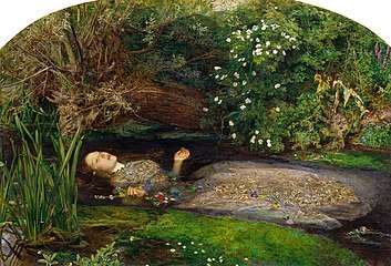
The Hogsmill has appeared in the art of John Millais in his rendition of Ophelia, and of William Holman Hunt who painted The Hireling Shepherd on the meadows by the Hogsmill, looking north towards Ewell Court Farm.[6][7] The doorway (to the soul) in Hunt's The Light of the World is believed to be part of a gunpowder mill on the Hogsmill at Ewell.[8]
Industry
Part of the course was engineered to be harnessed for watermills. Wheels driven by these joined those of nearby Whitton in the production of gunpowder; this may have continued for some time after the Napoleonic Wars to help supply the American Civil War.[2][8] Dynamos at a weir later generated electricity for Ewell Court House.[9]
A large sewage farm, producing agriculture along with upper allotments tended mainly by patients of a large isolation hospital, in the decades around 1890 employed dozens of workers from Ewell, principally draining Epsom, a town with a similar population as today in the Victorian period.[10]
Local legend
William the Conqueror is said to have "watered his horse" in the source waters near today's Spring Hotel.[2] Traditionally this was at the pool at grid reference TQ218628.
See also
- Tributaries of the River Thames
- List of rivers in England
- Watermills in the United Kingdom
References
- "River Hogsmill Integrated Urban Drainage DEFRA Pilot Study Volume 2 – Appendix A" (PDF). DEFRA. June 2008. Archived from the original (PDF) on 2 April 2013. Retrieved 23 December 2014.
- Talling, Paul. "London's lesser known rivers – Hogsmill River". London's Lost Rivers. Retrieved 24 December 2014.
- Blue Plaque on Clattern Bridge, Royal Borough of Kingston upon Thames
- "Thames Down Link" (PDF). Surrey County Council. p. 2. Archived from the original (PDF) on 25 May 2013. Retrieved 3 May 2014.
- Fure, Alison (September 2011). "Tolworth Brook". Wildlife Circus. Blogspot. Retrieved 25 December 2014.
- Rosenfield, Jason; Smith, Alison (2007). Millais (Exhibition Catalogue). Tate Publishing. ISBN 9789079310029.
- "Epsom and Ewell History Explorer: The PreRaphaelites". Retrieved 5 May 2012.
- "Epsom and Ewell History Explorer: Gunpowder Mills". Retrieved 5 May 2012.
- "Ewell Court House". Epsom and Ewell History Explorer. Retrieved 9 January 2019.
- https://maps.nls.uk/geo/explore/#zoom=16&lat=51.346&lon=-0.265&layers=168&b=7
External links
| Wikimedia Commons has media related to Hogsmill River. |
- Environment Agency: Flood warning notices
- Hogsmill Valley Walk
- The Hogsmill River
- Kingston upon Thames Archaeological Society: The Hogsmill Project
| Next confluence upstream | River Thames | Next confluence downstream |
| Longford River, Raven's Ait (north) | Hogsmill River | Sudbrook (stream) (north) |