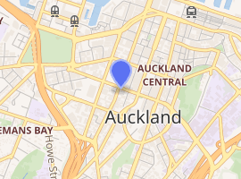
Hobson Street, Auckland
Hobson Street is the major street on the western side of Queen Street. It is a commercial and high-rise residential street, and provides access to the Auckland Northern Motorway going south, and the Northwest Motorway going west. For most of its length it is one-way. One block to the west is Nelson Street, which is one-way in the other direction and provides access to the central city for traffic exiting from the motorways. One block to the east is Albert Street, part of Mayoral Drive, and Vincent Street. The area encompassed by these streets is called Hobson Ridge by Statistics New Zealand.
| |
| Length | 1.4 km (0.9 mi) |
|---|---|
| Location | Auckland CBD, New Zealand |
| Postal code | 1010 |
| North end | Quay Street |
| South end | Auckland Northern Motorway |
Demographics
| Year | Pop. | ±% p.a. |
|---|---|---|
| 2006 | 4,533 | — |
| 2013 | 7,098 | +6.62% |
| 2018 | 8,190 | +2.90% |
| Source: [1] | ||
Hobson Ridge, comprising the statistical areas of Hobson Ridge North, Hobson Ridge Central and Hobson Ridge South, had a population of 8,190 at the 2018 New Zealand census, an increase of 1,092 people (15.4%) since the 2013 census, and an increase of 3,657 people (80.7%) since the 2006 census. There were 3,540 households. There were 4,422 males and 3,762 females, giving a sex ratio of 1.18 males per female, with 441 people (5.4%) aged under 15 years, 4,398 (53.7%) aged 15 to 29, 3,138 (38.3%) aged 30 to 64, and 213 (2.6%) aged 65 or older.
Ethnicities were 22.5% European/Pākehā, 3.2% Māori, 2.8% Pacific peoples, 67.2% Asian, and 8.7% other ethnicities (totals add to more than 100% since people could identify with multiple ethnicities).
The proportion of people born overseas was 81.1%, compared with 27.1% nationally.
Although some people objected to giving their religion, 40.7% had no religion, 25.4% were Christian, and 30.2% had other religions.
Of those at least 15 years old, 3,348 (43.2%) people had a bachelor or higher degree, and 378 (4.9%) people had no formal qualifications. The employment status of those at least 15 was that 3,852 (49.7%) people were employed full-time, 1,554 (20.1%) were part-time, and 423 (5.5%) were unemployed.[1]
History
Hobson Street existed by 1842[2] but it was not initially entirely urban, with the Auckland City Council being asked to prevent cattle from obstructing its footpaths in 1870.[3]
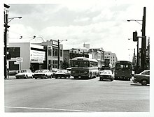
The Nelson Street-Hobson Street one-way system was in place in the early 1970s.[4]
Notable locations
- Auckland Harbour Board Workshops, corner Lower Hobson and Quay Street, 1944-1989, site spread between Lower Hobson St, Customs Street and Quay Street, repair of boats, cranes and other equipment.[5]
- Tepid Baths, corner Customs and Lower Hobson Streets, 1914, public indoor pool complex.[6]
- St Patrick's Presbytery, corner Wyndham and Hobson Streets, 1888, priest's residence and administrative centre of the Roman Catholic Diocese of Auckland. Part of the St Patrick's Cathedral site.[7]
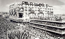
- Farmers Building, 35 Hobson Street, 1914, Retail, office and warehouse for Farmers Trading Company 1914-1991.
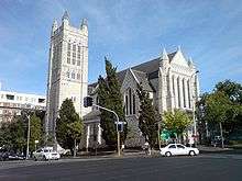
- St Matthew-in-the-City, 132-134 Hobson Street, 1905, neo-gothic Anglican church.[8]
- Higher Thought Temple, 1 Union Street, late 1920s, non-denominational church associated with the New Thought movement.[9]
- Wesleyan Chapel, 8A Pitt Street, 1860, oldest surviving brick church in New Zealand. Owned by the Independent Order of Odd Fellows for most of the 20th century.[10]
References
- "Statistical area 1 dataset for 2018 Census". Statistics New Zealand. March 2020. Hobson Ridge North (132700), Hobson Ridge Central (133400) and Hobson Ridge South (133800). 2018 Census place summary: Hobson Ridge North 2018 Census place summary: Hobson Ridge Central 2018 Census place summary: Hobson Ridge South
- "Sales by Auction". New Zealand Herald and Auckland Gazette. 16 March 1842. p. 1.
- Bush, G. W. A. (1971). Decently and in Order: The Centennial History of the Auckland City Council. Collins. p. 74.
- Bush, Graham W. A. (1991). Advance in Order: The Auckland City Council from Centenary to Reorganisation 1971-1989. Auckland City Council. p. 125. ISBN 0-908834-03-9.
- "Auckland Harbour Board Workshops". Register of Historic Places. Heritage New Zealand. Retrieved 22 July 2020.
- "Tepid Baths". Register of Historic Places. Heritage New Zealand. Retrieved 23 July 2020.
- "St Patrick's Presbytery (Catholic)". Register of Historic Places. Heritage New Zealand. Retrieved 23 July 2020.
- "St Matthew's-in-the-City Church (Anglican)". Register of Historic Places. Heritage New Zealand. Retrieved 23 July 2020.
- "Higher Thought Temple". Register of Historic Places. Heritage New Zealand. Retrieved 23 July 2020.
- "Wesleyan Chapel (Former)". Register of Historic Places. Heritage New Zealand. Retrieved 23 July 2020.