Guadalmedina
The Guadalmedina (from the Arabic wādi, “river” + medina, "city"; River of the City) is a river that runs through the city of Málaga, Spain. Historically, it has played an important role in the city's history, and has divided the city into two halves. The city's historic center is located on its left bank.
| Guadalmedina | |
|---|---|
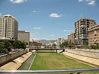 The Guadalmedina in Málaga | |
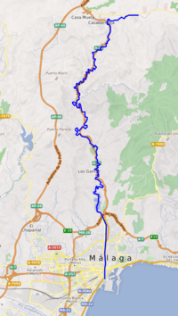 Course of the Guadalmedina | |
| Location | |
| Country | Spain |
| Physical characteristics | |
| Source | |
| • location | Sierra de Camarolos, Andalusia |
| Mouth | |
• location | Mediterranean Sea |
• coordinates | 36°42′23″N 4°25′33″W |
• elevation | 0 m (0 ft) |
| Length | 47 kilometres (29 mi) |
Course
The Guadalmedina has its source at the La Cruz Peak, in the Sierra de Camarolos mountain range, and it is 47 kilometres (29 mi) long. It reaches the Mediterranean in the center of the city of Málaga and flows through the Montes de Málaga Natural Park.[1]
It is a river subject to high seasonal variations and has five well defined tributaries which have their sources in the Montes de Málaga range, the Arroyo de las Vacas, Arroyo Chaperas, Arroyo Humaina, Arroyo Hondo and Arroyo de Los Frailes. All of these rivers are dry most of the year. Located in the mountains, the Limonero Dam on the Guadalmedina provides water for the area.[2]
See also
References
- "Parque Natural Montes de Málaga". Junta de Andalucia (in Spanish). Retrieved 20 May 2019.
- Fundación Ciedes. "Integración urbana del río Guadalmedina en Málaga". Alcolea Tarrago (in Spanish). Retrieved 20 May 2019.