Greater Malang
Greater Malang (Indonesian: Malang Raya) is a region in East Java, Indonesia, encompassing the municipality of Malang. Over 3 million people in East Java came from Greater Malang. The principal city, Malang is well-known as home of notable universities in Indonesia,[2] and its suburb, Batu is well-known as tourism center in East Java.[3]
Greater Malang | |
|---|---|
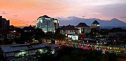 Malang cityscape at dusk | |
| Coordinates: 8°00′S 112°37′E | |
| Country | Indonesia |
| Province | East Java |
| Principal cities | |
| Satellite subregions | |
| Area | |
| • Total | 3,882.44 km2 (1,499.02 sq mi) |
| Population (2017 estimate) | |
| • Total | 3,642,007 |
| • Density | 940/km2 (2,400/sq mi) |
| Demonym(s) | Arek Malang or Arema[1] |
| Time zone | UTC+7 (Indonesia Western Time) |
| Area code | (+62) 341 |
| Vehicle sign | N |
| Highest elevation 3,676 m/12,060 ft (Semeru, in Malang Regency) | |
History
Karesidenan Malang
In Dutch colonial era, Greater Malang was an residency, old form of second subdivision, called Karesidenan Malang (Malang Residency), consists of 4 cities (Malang, Batu, Pasuruan, Probolinggo) and 4 regencies (Malang Regency, Pasuruan Regency, Probolinggo Regency, Lumajang Regency).[4][5] But now, the definition of Greater Malang is just consists to almost covered of Malang highlands area, namely Malang, Batu, and Malang Regency.[6]
Demography
| Administrative
division |
Area
(km2) |
Population
(2010 census) |
Population
(2017 estimate) |
Density/km2
(2017) |
|---|---|---|---|---|
| Malang City | 145.28 | 822,201 | 861,414 | 5,929 |
| Batu City | 202.3 | 190,806 | 203,997 | 1,008 |
| Malang Regency | 3,534.86 | 2,451,997 | 2,576,596 | 728 |
| Greater Malang | 3,882.44 | 3,465,004 | 3,642,007 | 938 |
Sources:
Geography
Greater Malang is located in middle of East Java, and eastern part of the region included the Eastern salient of Java region. The region covered over 3,000 km2.
The eastern section of Greater Malang, among Java's most rugged, isolated the eastern salient from Java's central heartland to its west.[8] The Tengger massif (including Mount Bromo), and Mount Semeru, Java's highest peak, lie in this section.[8] The western area of region also has mountainous area, including Arjuno-Welirang and Kawi-Butak. However, on southern side of Greater Malang is just lower elevation plain with southern coast bordering Indian Ocean and small karst hills below 1000 meters.[9]
Climate
With almost of the region are plateau or highlands (except the southern area), the climate of Greater Malang is milder than the rest of Indonesia. In middle of year, mountainous area of Greater Malang over 2000 meters above sea level, is dry winter with light snow and frost, which means the temperature always below zero Celsius during late night until morning, especially the light snow is commonly visible in Bromo Tengger Semeru National Park.[10]
| Climate data for Malang, East Java, Indonesia (elevation 450 m or 1,480 ft) | |||||||||||||
|---|---|---|---|---|---|---|---|---|---|---|---|---|---|
| Month | Jan | Feb | Mar | Apr | May | Jun | Jul | Aug | Sep | Oct | Nov | Dec | Year |
| Average high °C (°F) | 28.5 (83.3) |
28.5 (83.3) |
28.5 (83.3) |
28.7 (83.7) |
29.0 (84.2) |
28.8 (83.8) |
28.4 (83.1) |
29.3 (84.7) |
29.8 (85.6) |
30.2 (86.4) |
29.5 (85.1) |
28.5 (83.3) |
29.0 (84.1) |
| Daily mean °C (°F) | 24.0 (75.2) |
24.1 (75.4) |
24.0 (75.2) |
24.0 (75.2) |
23.9 (75.0) |
23.2 (73.8) |
22.4 (72.3) |
23.2 (73.8) |
23.6 (74.5) |
24.3 (75.7) |
24.3 (75.7) |
23.8 (74.8) |
23.7 (74.7) |
| Average low °C (°F) | 19.6 (67.3) |
19.7 (67.5) |
19.5 (67.1) |
19.3 (66.7) |
18.9 (66.0) |
17.7 (63.9) |
16.5 (61.7) |
17.1 (62.8) |
17.5 (63.5) |
18.5 (65.3) |
19.2 (66.6) |
19.1 (66.4) |
18.5 (65.4) |
| Average precipitation mm (inches) | 334 (13.1) |
307 (12.1) |
292 (11.5) |
173 (6.8) |
132 (5.2) |
77 (3.0) |
47 (1.9) |
26 (1.0) |
43 (1.7) |
106 (4.2) |
225 (8.9) |
326 (12.8) |
2,088 (82.2) |
| Average relative humidity (%) | 81.7 | 82.3 | 82.2 | 79.2 | 79.8 | 77.3 | 75.1 | 72.9 | 70.9 | 70.9 | 74.4 | 79.1 | 77.1 |
| Source 1: Climate-Data.org (temp & precip)[11] | |||||||||||||
| Source 2: Weatherbase (humidity)[12] | |||||||||||||
According to Köppen-Geiger climate classification, the climate of Malang city is tropical monsoon (Am).
| Climate data for Tulungrejo, Bumiaji, Batu (elevation 1,200 m or 3,900 ft) | |||||||||||||
|---|---|---|---|---|---|---|---|---|---|---|---|---|---|
| Month | Jan | Feb | Mar | Apr | May | Jun | Jul | Aug | Sep | Oct | Nov | Dec | Year |
| Average high °C (°F) | 21.4 (70.5) |
21.6 (70.9) |
21.6 (70.9) |
21.5 (70.7) |
21.5 (70.7) |
21.2 (70.2) |
20.7 (69.3) |
21 (70) |
21.8 (71.2) |
22.2 (72.0) |
21.8 (71.2) |
21.5 (70.7) |
21.5 (70.7) |
| Daily mean °C (°F) | 17.6 (63.7) |
17.7 (63.9) |
17.8 (64.0) |
17.8 (64.0) |
17.3 (63.1) |
16.9 (62.4) |
16.1 (61.0) |
16.2 (61.2) |
16.9 (62.4) |
17.6 (63.7) |
17.9 (64.2) |
17.6 (63.7) |
17.3 (63.1) |
| Average low °C (°F) | 13.9 (57.0) |
13.9 (57.0) |
14.1 (57.4) |
13.6 (56.5) |
13.2 (55.8) |
12.6 (54.7) |
11.5 (52.7) |
11.4 (52.5) |
12 (54) |
13.1 (55.6) |
14 (57) |
13.8 (56.8) |
13.1 (55.6) |
| Average precipitation mm (inches) | 406 (16.0) |
353 (13.9) |
395 (15.6) |
242 (9.5) |
176 (6.9) |
81 (3.2) |
52 (2.0) |
35 (1.4) |
46 (1.8) |
130 (5.1) |
282 (11.1) |
385 (15.2) |
2,583 (101.7) |
| Average relative humidity (%) | 81.7 | 82.3 | 82.2 | 79.2 | 79.8 | 77.3 | 75.1 | 72.9 | 70.9 | 70.9 | 74.4 | 79.1 | 77.1 |
| Source 1: Climate-Data.org (temp & precip)[13] | |||||||||||||
| Source 2: Weatherbase (humidity)[14] | |||||||||||||
| Climate data for Ngadas, Malang Regency (elevation 2,071 m or 6,795 ft) | |||||||||||||
|---|---|---|---|---|---|---|---|---|---|---|---|---|---|
| Month | Jan | Feb | Mar | Apr | May | Jun | Jul | Aug | Sep | Oct | Nov | Dec | Year |
| Average high °C (°F) | 18.3 (64.9) |
18.4 (65.1) |
18.6 (65.5) |
18.3 (64.9) |
18.2 (64.8) |
17.8 (64.0) |
17.2 (63.0) |
17.3 (63.1) |
18 (64) |
18.5 (65.3) |
18.3 (64.9) |
18.2 (64.8) |
18.1 (64.5) |
| Daily mean °C (°F) | 14.6 (58.3) |
14.6 (58.3) |
14.9 (58.8) |
14.4 (57.9) |
14.1 (57.4) |
13.6 (56.5) |
12.7 (54.9) |
12.7 (54.9) |
13.4 (56.1) |
14.1 (57.4) |
14.6 (58.3) |
14.5 (58.1) |
14.0 (57.2) |
| Average low °C (°F) | 10.9 (51.6) |
10.8 (51.4) |
11.2 (52.2) |
10.6 (51.1) |
10.1 (50.2) |
9.4 (48.9) |
8.2 (46.8) |
8.2 (46.8) |
8.8 (47.8) |
9.8 (49.6) |
11 (52) |
10.9 (51.6) |
10.0 (50.0) |
| Average precipitation mm (inches) | 297 (11.7) |
328 (12.9) |
347 (13.7) |
182 (7.2) |
108 (4.3) |
63 (2.5) |
31 (1.2) |
15 (0.6) |
20 (0.8) |
79 (3.1) |
159 (6.3) |
319 (12.6) |
1,948 (76.9) |
| Source: Climate-Data.org (temp & precip)[15] | |||||||||||||
According to Köppen-Geiger climate classification, the climate of Batu city and Upper Greater Malang over 1000 meters above sea level classified as subtropical highland variety(Cwb).
Panoramas
.jpg)
.jpg)
References
- "Arti kata Arema – Kamus Besar Bahasa Indonesia (KBBI) Online". artikata.simomot.com. Retrieved 8 October 2018.
- "Malang – Merdeka.com | Malang sebagai kota pendidikan sejak masa Hindia Belanda". malang.merdeka.com. Retrieved 24 April 2019.
- Pemerintah Kota Batu. "Sejarah Kota Batu". batukota.go.id. Retrieved 24 April 2019.
- "Sejarah Kota Malang (3) Kota Kolonial Berawal dari Loji". Cendana News (in Indonesian). 1 January 2017. Retrieved 24 April 2019.
- nGalamediaLABS. "Pemerintahan Karesidenan Malang Pada Masa Perang Kemerdekaan". ngalam.id (in Indonesian). Retrieved 24 April 2019.
- "Mengetahui Secara Ringkas Tentang Malang Raya". Dare to Start (in Indonesian). 2 January 2015. Retrieved 24 April 2019.
- Statistics Indonesia. "Jumlah Penduduk dan Laju Pertumbuhan Penduduk Menurut Kabupaten/Kota di Provinsi Jawa Timur, 2010, 2016 dan 2017". jatim.bps.go.id (in Indonesian). Archived from the original on 24 April 2019. Retrieved 24 April 2019.
- Hefner, Robert W. (1 February 1990). Hindu Javanese: Tengger Tradition and Islam. Princeton University Press. pp. 6, 23. ISBN 9780691028569.
- Mega, Sophia (3 November 2016). "Mengenal Lebih Dekat Kondisi Geografis Malang". Ngalam.co (in Indonesian). Retrieved 25 April 2019.
- Rofiq, M. "Brrr.....Kawasan Bromo Membeku, Embun Salju Selimuti Dedaunan". detiknews. Retrieved 25 April 2019.
- "Climate: Malang". Climate-Data.org. Retrieved 19 May 2016.
- "MALANG, INDONESIA". Weatherbase. Retrieved 19 May 2016.
- "Climate: Tulungrejo, Bumiaji, Batu City". Climate-Data.org. Retrieved 18 December 2018.
- "BATU, INDONESIA". Weatherbase. Retrieved 19 May 2016.
- "Climate: Ngadas, Malang Regency". Climate-Data.org. Retrieved 25 April 2019.