Georgia State Route 358
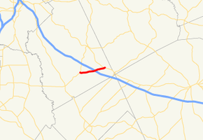
State Route 358 (SR 358) is a 6.4-mile-long (10.3 km) west–east state highway located entirely in the southeastern part of Twiggs County in the central part of the U.S. state of Georgia. It is mainly a rural route. The highway was built along its current alignment between 1963 and 1966.
| ||||
|---|---|---|---|---|
| Homer Chance Highway | ||||
 | ||||
| Route information | ||||
| Maintained by GDOT | ||||
| Length | 6.4 mi[1] (10.3 km) | |||
| Existed | 1966[2][3]–present | |||
| Major junctions | ||||
| West end | ||||
| East end | ||||
| Location | ||||
| Counties | Twiggs | |||
| Highway system | ||||
| ||||

Route description
SR 358 begins at an intersection with SR 96 south-southeast of Jeffersonville. The route travels to the east-northeast along Homer Chance Highway to an interchange with Interstate 16 (I-16) just east of its midpoint. It continues to the east-northeast and meets its eastern terminus, an intersection with US 80/SR 19 west of Danville.[1]
SR 358 is not part of the National Highway System, a system of roadways important to the nation's economy, defense, and mobility.[4]
Major intersections
The entire route is in Twiggs County.
| Location | mi[1] | km | Destinations | Notes | |
|---|---|---|---|---|---|
| | 0.0 | 0.0 | Western terminus | ||
| | 3.6 | 5.8 | I-16 exit 27 | ||
| | 6.4 | 10.3 | Eastern terminus | ||
| 1.000 mi = 1.609 km; 1.000 km = 0.621 mi | |||||
See also
.svg.png)

References
- Google (November 2, 2013). "Route of SR 358" (Map). Google Maps. Google. Retrieved November 2, 2013.
- Georgia State Highway System (PDF) (Map). Cartography by GSHD. Georgia State Highway Department. June 1, 1963. Retrieved August 16, 2015.
- Georgia State Highway System (PDF) (Map). Cartography by GSHD. Georgia State Highway Department. January 1, 1966. Retrieved August 16, 2015.
- "National Highway System: Georgia" (PDF). Federal Highway Administration. October 1, 2012. Retrieved October 18, 2013.