Georgia State Route 198
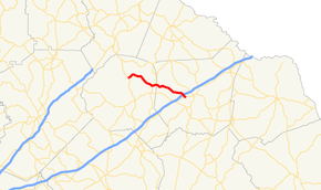
State Route 198 (SR 198) is a state highway that runs northwest–southeast for 14.3 miles (23.0 km) through portions of Banks and Franklin counties in the northeastern part of the U.S. state of Georgia.
| ||||
|---|---|---|---|---|
 | ||||
| Route information | ||||
| Maintained by GDOT | ||||
| Length | 14.3 mi[1] (23.0 km) | |||
| Major junctions | ||||
| West end | ||||
| East end | ||||
| Location | ||||
| Counties | Banks, Franklin | |||
| Highway system | ||||
| ||||

Route description
The route begins at an intersection with US 441/SR 15 southeast of Baldwin, in Banks County. It curves to the southeast to an intersection with SR 63, just before crossing into Franklin County. It crosses over, but does not have an interchange with Interstate 85 just prior to meeting its eastern terminus, an intersection with SR 59 southwest of Carnesville.
Major intersections
| County | Location | mi[1] | km | Destinations | Notes |
|---|---|---|---|---|---|
| Banks | | 0.0 | 0.0 | Western terminus | |
| | 6.5 | 10.5 | |||
| Franklin | | 14.3 | 23.0 | Eastern terminus | |
| 1.000 mi = 1.609 km; 1.000 km = 0.621 mi | |||||
See also
.svg.png)

References
- Google (June 4, 2013). "Route of SR 198" (Map). Google Maps. Google. Retrieved June 4, 2013.
External links
This article is issued from Wikipedia. The text is licensed under Creative Commons - Attribution - Sharealike. Additional terms may apply for the media files.