Gazey Nunatak
Gazey Nunatak (Bulgarian: нунатак Газей, ‘Nunatak Gazey’ \'nu-na-tak ga-'zey\) is the partly ice-covered ridge extending 2.9 km in north-south direction and 830 m wide, rising to 1500 m in Coulter Glacier, Havre Mountains in northern Alexander Island, Antarctica. The feature is named after Gazey Peak in Pirin Mountains, Bulgaria.
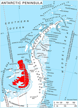
Location of Alexander Island in the Antarctic Peninsula region
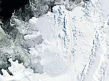
Satellite image of Alexander Island
Location
Gazey Nunatak is located at 69°18′58″S 71°50′28″W, which is 5.26 km northeast of Goleminov Point, 6.15 km south-southeast of Simon Peak, 14.5 km southwest of Mount Pontida and 8 km north of Dint Island.
Maps
- British Antarctic Territory. Scale 1:200000 topographic map. DOS 610 – W 69 70. Tolworth, UK, 1971
- Antarctic Digital Database (ADD). Scale 1:250000 topographic map of Antarctica. Scientific Committee on Antarctic Research (SCAR). Since 1993, regularly upgraded and updated
gollark: ! is just the kind of a runtime compile error exception.
gollark: Some stages of the process are even lossless!
gollark: Your program is fed to a GTech™-supplied neural network, which outputs English, which Copilot translates into JS, which is transpiled into AssemblyScript, which becomes WASM, which becomes platform machine code.
gollark: Poorly.
gollark: It has multiple GCs, yes.
References
- Bulgarian Antarctic Gazetteer. Antarctic Place-names Commission. (details in Bulgarian, basic data in English)
- Gazey Nunatak. SCAR Composite Gazetteer of Antarctica
External links
- Gazey Nunatak. Copernix satellite image
This article includes information from the Antarctic Place-names Commission of Bulgaria which is used with permission.
This article is issued from Wikipedia. The text is licensed under Creative Commons - Attribution - Sharealike. Additional terms may apply for the media files.