Fault trace
A fault trace describes the intersection of a geological fault with the Earth's surface, which leaves a visible disturbance on the surface, usually looking like a crack in the surface with jagged rock structures protruding outward. The term also applies to a line plotted on a geological map to represent a fault. These fractures tend to occur when a slip surface expands from a fault core, especially during an earthquake. This tends to occur with fault displacement, in which surfaces on both sides of a fault, known as fault blocks, separate horizontally or vertically.[1]
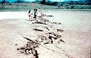
Along the Motagua Fault trace (1976 Guatemala earthquake) where it crosses the Gualán soccer field. This zigzag type of fault trace is known as "mole track", which is best developed in hard-packed, brittle surface materials.
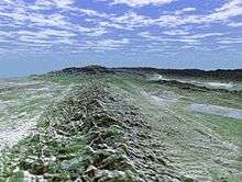
The San Andreas fault trace runs along the base of the Temblor Range of mountains near Bakersfield, California. (The fault trace is a linear feature to the right of the mountain ridge.)
See also
References
- Torabi, Anita; Berg, Silje Støren (2011-08-01). "Scaling of fault attributes: A review". Marine and Petroleum Geology. 28 (8): 1444–1460. doi:10.1016/j.marpetgeo.2011.04.003. ISSN 0264-8172.
- Balance, P. F. (2009-04-08). Sedimentation in Oblique-slip Mobile Zones. John Wiley & Sons. ISBN 978-1-4443-0374-2.
- Bouchon, Michel (1980). "The motion of the ground during an earthquake: 2. The case of a dip slip fault". Journal of Geophysical Research: Solid Earth. 85 (B1): 367–375. doi:10.1029/JB085iB01p00367. ISSN 2156-2202.
- Katz, Yoram; Weinberger, Ram; Aydin, Atilla (2004-03-01). "Geometry and kinematic evolution of Riedel shear structures, Capitol Reef National Park, Utah". Journal of Structural Geology. 26 (3): 491–501. doi:10.1016/j.jsg.2003.08.003. ISSN 0191-8141.
- Treiman, Allan H. (March 2008). "Ancient groundwater flow in the Valles Marineris on Mars inferred from fault trace ridges". Nature Geoscience. 1 (3): 181–183. doi:10.1038/ngeo131. ISSN 1752-0908.
- Philip, G. (2007-11-01). "Remote sensing data analysis for mapping active faults in the northwestern part of Kangra Valley, NW Himalaya, India". International Journal of Remote Sensing. 28 (21): 4745–4761. doi:10.1080/01431160701264243. ISSN 0143-1161.
This article is issued from Wikipedia. The text is licensed under Creative Commons - Attribution - Sharealike. Additional terms may apply for the media files.