Ellicott's Stone
Ellicott's Stone, also known as the Ellicott Stone, is a boundary marker in northern Mobile County, Alabama. It was placed on April 10, 1799 by a joint U.S.-Spanish survey party headed by Andrew Ellicott.[3][4] It was added to the National Register of Historic Places on April 11, 1973.[1]
Ellicott Stone | |
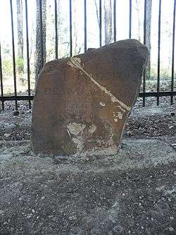 The south side of the stone. It reads: Dominio De S.M. Carlos IV, Lat. 31, 1799. | |
  | |
| Nearest city | Bucks, Alabama |
|---|---|
| Coordinates | 30°59′52.11″N 88°01′21.06″W |
| Area | less than one acre |
| Built | 1799 |
| NRHP reference No. | 73000359[1][2] |
| Added to NRHP | April 11, 1973 |
It is the only known stone monument set by Ellicott when he surveyed the 31st parallel north latitude, which served as the boundary line between the Mississippi Territory in the United States and Spanish West Florida.[4] The boundary line extended along the 31st parallel from the Mississippi River east to the Chattahoochee River, as set forth in the 1795 Pinckney Treaty, formally known as the Treaty of San Lorenzo.[5][6]
Ellicott's Stone is the initial point for all United States Public Land surveys in the southern region of Alabama and Mississippi.[2][4] It is the point of intersection of what is known today as the St. Stephens meridian and the St. Stephens baseline.[4] All townships in the area are numbered from the stone.[2]
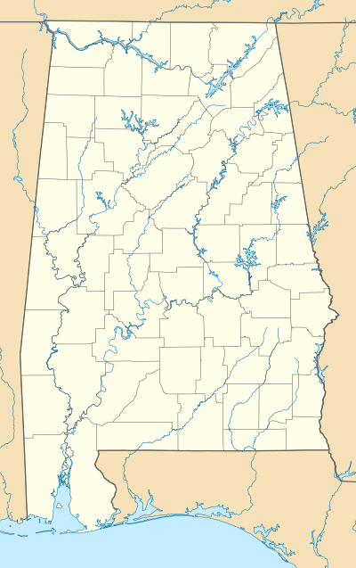
The marker stone is located east of U.S. Route 43 in Ellicott Stone Historical Park, about 1 mile (1.6 km) south of Bucks, Alabama.[2][7][8] The park was established in 1917.[7] It is now near the James M. Barry Electric Generating Plant, west of the Mobile River.[8]
Description
The stone marker, a ferruginous sandstone block about two feet high and eight inches (203 mm) thick, is near the west bank of the Mobile River. On the northern side of the stone is an inscription stating "U.S. Lat. 31, 1799." The inscription on the southern side reads "Dominio De S.M. Carlos IV, Lat. 31, 1799." (Dominion of his majesty King Charles IV, Lat. 31, 1799)[5][6]
References
- "Ellicott Stone". NPGallery Digital Asset Management System. United States Department of the Interior: National Park Service. Retrieved 2018-05-27.
- Floyd, W. Warner, Executive Director, Alabama Historical Commission, Montgomery, Alabama (1972-10-04). "Ellicott Stone". National Register of Historic Places Inventory — Nomination Form. United States Department of the Interior: National Park Service. Retrieved 2018-05-27.
- "American Society of Civil Engineers". "Ellicott's Stone". "History & Heritage of Civil Engineering". Archived from the original on 2012-02-10. Retrieved 2008-03-06.
- (1) "Alabama Surveying History". "Alabama Society of Professional Land Surveyors". Archived from the original on 2008-05-13. Retrieved 2008-03-06.
- "Historic Markers: Mobile County". Alabama Department of Archives and History. Archived from the original on 2008-02-07. Retrieved 2008-03-06.
- "Mobile: Alabama's Tricentennial City". "Alabama Department of Archives and History". Retrieved 2008-03-06.
- Hilton, Mark (2013-12-05). ""Ellicott's Stone" marker". HMdb: The Historical Marker Database. Retrieved 2018-05-27.
- Peacock, Lee (2013-07-15). "Life List Update – No. 723: Visit Ellicott's Stone". Dispatches from the LP-OP. Retrieved 2017-05-27 – via Blogspot.
External links
![]()
- "St. Stephens Meridian". The Center for Land Use Interpretation. Retrieved 2012-10-06.
- "Surveyor finds old mounds marking 1799 creation of Alabama-Florida border". AL.com. February 1, 2010. Retrieved 2012-10-06.
| Topics | |
|---|---|
| Lists by state |
|
| Lists by insular areas | |
| Lists by associated state | |
| Other areas | |
| Related | |
| |