El Toro (California)
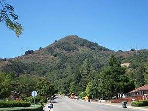
El Toro is a prominent hill located along the eastern foothills of the Santa Cruz Mountains in southwest Santa Clara County, California. The iconic landmark is partially owned by the city of Morgan Hill, and its silhouette is incorporated in the city logo.
| El Toro | |
|---|---|
 | |
| Highest point | |
| Elevation | 1,427 ft (435 m) NAVD 88[1] |
| Prominence | 1,077 ft (328 m) |
| Coordinates | 37°07′14″N 121°40′24″W [1] |
| Geography | |
 El Toro | |
| Location | Morgan Hill, California, U.S. |
| Parent range | Santa Cruz Mountains |
| Topo map | USGS El Toro |
History
In Spanish, "El Toro" means "The Bull".
According to local legend, 19th century American poet Bret Harte named the hill when he climbed it and discovered two bulls fighting near the summit (they subsequently chased him back down).
Hiking
Although a portion of the hill is on public land, access to the summit is through privately owned surrounding lands.
Since 2008, the Morgan Hill Historical Society had sponsored annual spring hikes up to the summit.[2] However, due to increased contention over property rights, no public hikes to the summit have been permitted since 2011.[3]
In 2012, the Morgan Hill Parks and Recreation Commission re-initiated a study started a decade earlier to create a public trail to the summit. The results of the study and proposal for the trail are available on the Commission's website.[4]
In 2013, the Commission held the first of a series of public meetings on the proposal to create the trail and associated facilities nearby.[5]
In 2015, an "Access Strategy" to determine the proposed trail access points was developed by the Commission and approved by the City Council .[6]
In 2016, the Commission will hold a public meeting on the proposal to create a non-paved public trail on the eastern side of El Toro, and to address concerns on safety, parking, litter, and impacts on wildlife.[7]
References
- "El Toro Reset". NGS data sheet. U.S. National Geodetic Survey. Retrieved 2014-03-03.
- Hike Up El Toro, March 2010
- Hiking to El Toro Cancelled Indefinitely, April 2012
- Morgan Hill Parks and Recreation Commission on El Toro Trail, April 2012
- Morgan Hill Public Meeting on El Toro Trail, March 2013
- El Toro Trail Access Strategy, February 2015
- Morgan Hill Public Meeting on El Toro Trail, November 2016
External links
- "El Toro". Geographic Names Information System. United States Geological Survey. Retrieved 2013-04-25.