Dowles Brook
Dowles Brook flows through the heart of the Wyre Forest, into the former parish of Dowles and into the River Severn. During the summer of 2012, with funding from the Environment Agency, the Worcestershire Wildlife Trust attempted an ambitious project to eradicate the invasive Himalayan Balsam from a 3 km watercourse, hoping to improve biodiversity and reduce soil erosion. A pilot project was carried out on the Lem Brook, a tributary of the Dowles Brook.This was a success but as the seeds persist in the soil for up to two years repeat eradication is planned for 2014 followed by close monitoring.[2]
| Dowles Brook | |
|---|---|
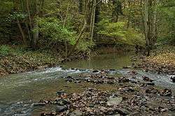 Dowles Brook within the Wyre Forest | |
 Location within Worcestershire | |
| Location | |
| Country | England |
| Counties | Shropshire, Worcestershire |
| Physical characteristics | |
| Source | |
| • location | Bagginswood, Shropshire |
| Mouth | |
• location | River Severn, Worcestershire |
• coordinates | 52°23′06″N 2°19′29″W |
| Length | 15.5 km (9.6 mi)[1] |
| Basin size | 46.2 km2 (17.8 sq mi)[1] |
References
- "WFD Surface Water Classification Status and Objectives 2012 csv files". Environment Agency. Archived from the original on 24 February 2014. Retrieved 20 June 2014.
- Peter Case April 2013 Open Space Invaders, p53 Worcestershire Life Cheltenham, Gloucestershire.
This article is issued from Wikipedia. The text is licensed under Creative Commons - Attribution - Sharealike. Additional terms may apply for the media files.