Devore Peak
Devore Peak is an 8,360+ ft (2,550+ m) mountain summit located in the Glacier Peak Wilderness of the North Cascades in Washington state.[3] The mountain is situated in Chelan County, on land managed by Wenatchee National Forest. Its nearest higher peak is Martin Peak, 3.36 mi (5.41 km) to the southwest, and Tupshin Peak lies 1.55 mi (2.49 km) to the north-northeast.[1] Precipitation runoff from the peak drains to nearby Lake Chelan via tributaries of the Stehekin River and Devore Creek.
| Devore Peak | |
|---|---|
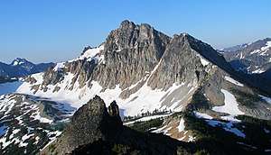 Devore Peak seen from White Goat Mountain | |
| Highest point | |
| Elevation | 8,360 ft (2,550 m) [1] |
| Prominence | 1,722 ft (525 m) [1] |
| Parent peak | Martin Peak 8511 ft[1] |
| Coordinates | 48°16′36″N 120°45′55″W [1] |
| Geography | |
 Devore Peak Washington, U.S.  Devore Peak Devore Peak (the United States) | |
| Parent range | North Cascades Cascade Range |
| Topo map | USGS Mount Lyall |
| Geology | |
| Type of rock | Granodiorite |
| Climbing | |
| First ascent | July 28, 1940 by Everett Darr, Ida Darr, Abigail Avery, Stuart B. Avery, Jane Foster McConnell, Grant McConnell, Paul Parker[2] |
| Easiest route | Climbing class 4 |
Climate
Most weather fronts originate in the Pacific Ocean, and travel northeast toward the Cascade Mountains. As fronts approach the North Cascades, they are forced upward by the peaks of the Cascade Range, causing them to drop their moisture in the form of rain or snowfall onto the Cascades (Orographic lift). As a result, the North Cascades experiences high precipitation, especially during the winter months in the form of snowfall.[4] During winter months, weather is usually cloudy, but, due to high pressure systems over the Pacific Ocean that intensify during summer months, there is often little or no cloud cover during the summer.[4]
Geology
The North Cascades feature some of the most rugged topography in the Cascade Range with craggy peaks, spires, ridges, and deep glacial valleys. Geological events occurring many years ago created the diverse topography and drastic elevation changes over the Cascade Range leading to the various climate differences.
The history of the formation of the Cascade Mountains dates back millions of years ago to the late Eocene Epoch.[5] With the North American Plate overriding the Pacific Plate, episodes of volcanic igneous activity persisted.[5] Glacier Peak, a stratovolcano that is 19.74 mi (31.77 km) southwest of Devore Peak, began forming in the mid-Pleistocene.[4] In addition, small fragments of the oceanic and continental lithosphere called terranes created the North Cascades about 50 million years ago.[5]
During the Pleistocene period dating back over two million years ago, glaciation advancing and retreating repeatedly scoured the landscape leaving deposits of rock debris.[5] The "U"-shaped cross section of the river valleys are a result of recent glaciation. Uplift and faulting in combination with glaciation have been the dominant processes which have created the tall peaks and deep valleys of the North Cascades area.
See also

References
- "Devore Peak, Washington". Peakbagger.com.
- WASHINGTON'S HIGHEST MOUNTAINS FIRST ASCENT CHRONOLOGY Rhinoclimbs.com
- "Devore Peak". Geographic Names Information System. United States Geological Survey. Retrieved 2019-05-06.
- Beckey, Fred W. Cascade Alpine Guide, Climbing and High Routes. Seattle, WA: Mountaineers Books, 2008.
- Kruckeberg, Arthur (1991). The Natural History of Puget Sound Country. University of Washington Press.
External links
- Weather forecast: Devore Peak