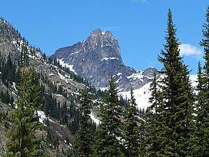
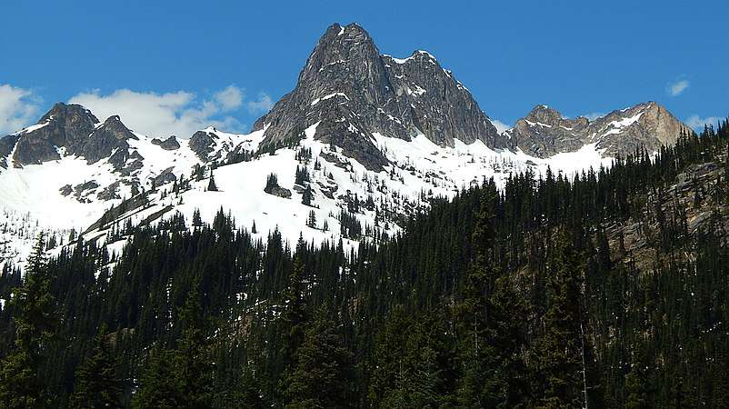
Cutthroat Peak
Cutthroat Peak is an 8,050-foot (2,450-metre) granitic mountain located on the boundary of Chelan County and Skagit County, in Washington state. The mountain is part of the Okanagan Range in the Cascade Range. Cutthroat Peak is about two miles west of Washington Pass and one mile east of Rainy Pass. It's a prominent landmark along the North Cascades Highway. There is also a Cutthroat Lake, Cutthroat Creek, and Cutthroat Pass on its north and east aspects. Molar Tooth is a granite pillar half a mile north on the ridge extending to Cutthroat Pass.
| Cutthroat Peak | |
|---|---|
 | |
| Highest point | |
| Elevation | 8,050 ft (2,450 m) [1] |
| Prominence | 1,730 ft (530 m) [1] |
| Coordinates | 48°31′35″N 120°42′13″W |
| Geography | |
 Cutthroat Peak Location in Washington  Cutthroat Peak Cutthroat Peak (the United States) | |
| Location | Chelan County, Washington |
| Parent range | North Cascades Cascade Range |
| Topo map | USGS Washington Pass |
| Geology | |
| Type of rock | Granite |
| Climbing | |
| First ascent | July 22, 1937 by Kenneth Adam, Raffi Bedayn[2] |
| Easiest route | South Buttress class 5.8 |
Climate
Cutthroat Peak is located in the marine west coast climate zone of western North America.[3] Most weather fronts originate in the Pacific Ocean, and travel northeast toward the Cascade Mountains. As fronts approach the North Cascades, they are forced upward by the peaks of the Cascade Range (Orographic lift), causing them to drop their moisture in the form of rain or snowfall onto the Cascades. As a result, the west side of the North Cascades experiences high precipitation, especially during the winter months in the form of snowfall.[3] Due to its temperate climate and proximity to the Pacific Ocean, areas west of the Cascade Crest very rarely experience temperatures below 0 °F (−18 °C) or above 80 °F (27 °C).[3] During winter months, weather is usually cloudy, but, due to high pressure systems over the Pacific Ocean that intensify during summer months, there is often little or no cloud cover during the summer.[4] Because of maritime influence, snow tends to be wet and heavy, resulting in high avalanche danger.[4]
Geology
The North Cascades features some of the most rugged topography in the Cascade Range with craggy peaks, ridges, and deep glacial valleys. Geological events occurring many years ago created the diverse topography and drastic elevation changes over the Cascade Range leading to the various climate differences. These climate differences lead to vegetation variety defining the ecoregions in this area.
The history of the formation of the Cascade Mountains dates back millions of years ago to the late Eocene Epoch.[5] With the North American Plate overriding the Pacific Plate, episodes of volcanic igneous activity persisted.[5] In addition, small fragments of the oceanic and continental lithosphere called terranes created the North Cascades about 50 million years ago.[5]
During the Pleistocene period dating back over two million years ago, glaciation advancing and retreating repeatedly scoured the landscape leaving deposits of rock debris.[5] The "U"-shaped cross section of the river valleys are a result of recent glaciation. Uplift and faulting in combination with glaciation have been the dominant processes which have created the tall peaks and deep valleys of the North Cascades area.
Gallery
 Cutthroat Peak
 Whistler and Cutthroat
References
- "Cutthroat Peak, Washington". Peakbagger.com.
- Beckey, Fred W. (2009). Cascade Alpine Guide: climbing and high routes, Vol. 3, Rainy Pass to Fraser River (3rd ed.). Mountaineers Books. p. 302. ISBN 978-1-59485-136-0.
- Beckey, p. 15
- Beckey, p. 16
- Kruckeberg, Arthur (1991). The Natural History of Puget Sound Country. University of Washington Press.
External links
- Cutthroat Peak weather: Mountain Forecast