Contact (geology)
A geological contact is a boundary which separates one rock body from another.[1] There are three different types of contacts, which are divided into primary contacts and secondary contacts. Primary contacts include depositional, unconformable, and intrusive contacts. Secondary contacts include those induced by tectonic activity such as fault contacts and shear zones.
Types of contacts
Depositional
Conformable
Conformable contacts represent no time gap in the geologic record.[2] They are usually planar, though they may have slightly irregular topography. These contacts represent continual, uninterrupted deposition and accumulation of sedimentary rocks, or represent lava flows.[3] Bedding contacts represent a change in the rate of deposition or changes in the depositional environment.
Non-conformable
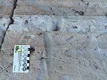
Unconformities are gaps in the geologic record within a stratigraphic unit. These gaps can be caused by periods of non-deposition or by erosion.[2] As a result, two adjacent rock units may have significantly different ages. There are three types of unconformities: disconformity, angular unconformity, and non-conformity.
Disconformity
The separated layers with a disconformity contact are horizontal to each other. The surface of the unconformity is parallel to the layering or bedding of the rocks above.[2]
Disconformities are challenging to detect as the layers are horizontal and parallel to each other. Geologists must often use other ways to detect disconformities such as identifying key fossils[1], analysing regional geology, and radiometric dating of the strata.
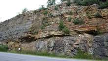
Angular unconformity

This type of unconformity separates layers above and below that are not parallel to each other.[4] Relatively flat younger strata overlay steeply dipping older strata. An example of this type of unconformity is the Hutton Unconformity at Siccar Point, Scotland, UK.[5] Other angular unconformities may not be as obvious. Regional context is essential when identifying angular unconformities.
Non-conformity
When younger sedimentary or volcanic rocks overlay older igneous or metamorphic rock, it is called a non-conformity.[2] The time gap can represent over one billion years in some cases.[2] The most common example is the non-conformity separating Precambrian basement rock from Paleozoic, Mesozoic, or Cenozoic sedimentary and volcanic rocks. An example of this unconformity is the boundary of the Quaternary sediments which lie on top of the Precambrian Canadian Shield in northeastern Canada.
Intrusive
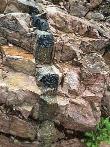
Intrusive contacts are the surfaces between host (or country) rock and an intrusive magmatic body.[2] The older country rock is crosscut by a younger magmatic body. The nature of the intruding body depends its composition and depth. Common examples are igneous dikes, sills, plutons, and batholiths. Depending on the composition of the magma, the intrusive body may have a complex internal structure which can provide insight into its emplacement.
The country rock responds to the immense heat from the intruding body numerous ways. Chill margins are created if the magma is cooled too quickly to fully crystallise. The result is a distinct boundary of very fine grain igneous rock along the border of the country rock.[2] The surrounding rock may be "baked" through contact metamorphism, resulting in non-foliated metamorphic rocks.[1] Rocks that were originally limestone, quartz sandstone, and shale become marble, quartzite, and hornfels, respectively.
Fault
Fault and shear zone contacts can be represented by either discrete breaks and discontinuities, or ductile deformation without a physical break in stratigraphy.[6] Fault surface contacts show discrete breaks and have an attitude and position which describes the contact between two formations.[2] These fault surfaces can be polished into slickensided surfaces which depict striations in the direction of the fault movement.[2] Shear zones are different as there is no physical break displayed, but there is displacement.[1]
Significance and application

Identifying and understanding the relationship between contacts is important in determining relative ages of rocks and formations.[3] Contacts are a key feature used to create geological maps. Cross-cutting relationships of these contacts can be used to determine the relative geological history of an area or of an outcrop.
Important geological contacts
The golden spikes on geologic timescales represent internationally agreed upon references for the boundaries of the stages in the geologic timescale. These contacts have been identified by the International Commission on Stratigraphy and they are known as GSSPs, or global boundary stratotype section and points. Some of these boundary points are at physical locations, while others are in ice drill core sections, or have been defined chronometrically.
The GSSP for the Danian Stage marks the end of the Cretaceous and the beginning of the Paleocene Series.[7] Located in Tunisia, the contact is described as a reddish layer at the base of a dark clay layer. This reddish layer is the Iridium Anomaly, representative of the fallout of the major impact that resulted in the mass extinction event that ended the Cretaceous.
See also
- Igneous rocks
- Metamorphic rocks
- Sedimentary rocks
- Structural geology
- Steno's Laws of Stratigraphy
References
- Plummer, C.C.; Carlson, D.H.; Hammersley, L. (2015). Physical Geology, 15th ed. New York, USA: McGraw-Hill Education. ISBN 978-0-07-809610-5.
- Davis, G.H.; Reynolds, S.J.; Kluth, C.F. (2011). Structural Geology of Rocks and Regions, 3rd ed. New Jersey, USA: John Wiley & Sons, Inc.
- "Geologic Contacts" (PDF). University of Western Ontario. 2005.
- Lisle, R.J. (2004). Geological Structures and Maps: A Practical Guide, 3rd ed. Oxford, UK: Elsevier Butterworth-Heinemann.
- Mehmood, Qasim. "Geologic Contacts". Learning Geology.
- Twiss, R.J.; Moores, E.M. (2007). Structural Geology, 2nd ed. New York, USA: W.H. Freeman & Company.
- "GSSP for Danian Stage". Stratigraphy.org.