Columbia River Estuary
The Columbia River Estuary is an estuary and a bay on the Oregon–Washington border and the Pacific Coast of the United States.
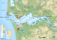
The extent of the Columbia River Estuary
During spring heavy flow, at its outermost edge the plume may extend 100 miles (160 km) miles offshore to as far south as Newport, Oregon. In fall, more a localized feature around the mouth of the river may spread like a narrow jet along the Washington coast, less than 10 miles (16 km) offshore.[1]
Winds, and the tidal Coriolis effect also affect its position.[1]
If the Columbia River Estuary is defined by the region that experiences ocean tides, then the estuary extends up the Columbia River to Bonneville Dam and up the Willamette River to Willamette Falls (south of Portland at Oregon City, Oregon). If the estuary is defined by the geographic land form or by the inland extent of salinity, then the estuary extends only as far as Welch Island.
Settlements on the estuary include Astoria and Warrenton in Oregon, and Ilwaco in Washington. The gathering and retail/wholesale distribution of seafood is a prominent local industry and producer of jobs in the estuary.
External links
| Wikimedia Commons has media related to Columbia River Estuary. |
- Lower Columbia Estuary Partnership
- CREST, Columbia River Estuary Study Taskforce
- Columbia River Estuary, NOAA
- Oregon State University site
References
- Thompson, Chuck (June 25, 2020). "Major acquisition nets Columbia River tribes new clout". Columbia Insight.